 Route Editor

| Guide | ♦ | 15 Triplogs | 0 Topics |
details | drive | permit | forecast | 🔥 route |
stats |
photos | triplogs | topics | location |
| 94 | 15 | 0 |
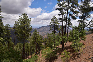
Cave Creek Views by markthurman53   CHIRICAHUA MOUNTAINS CHIRICAHUA MOUNTAINSThe Chiricahua Mountains are located in far southeast Arizona on the New Mexico and Mexico border. This mountain is probably the remotest of the over 9000 feet high sky island ranges. The closest towns are Wilcox, 40 miles to the north, and Douglas, about the same to the south. No paved roads enter this range except a short portion on the east side of the range near Portal, Arizona, and there isn’t any easy way to get there. One dirt road traverses the range from the west side near the Chiricahua Monument and ends at Portal. The remoteness makes for great hiking if you prefer solitude. Many of the trails are in poor condition with a few exceptions, ravaged by the Rattlesnake fire in 1994 and the Horseshoe 2 fire of 2011. If you are into route finding, then this is the place to hike. HERB MARTYR TRAIL #247
From the Herb Martyr Campground, The Herb Martyr Trail #247 heads up to and ends at a junction with the Snowshed Trail #246 at about its midway point. The trail follows along cave Creek for about 1 mile, then follows along a ridge up to the Snowshed Ridge. Because this trail follows a ridge, there are some great views to the west up Cave Creek Canyon up to Chiricahua Peak. The scenery along the trail is quite impressive too. There are some magnificent Ponderosa Pines and Douglas-Fir trees along this trail. Being this trail ends at about the midway point on the Snowshed Trail, it is the preferred trail to take if your destination is the crest of the Chiricahua Mountains. Description From the Herb Martyr Campground, the trail heads south along Cave Creek. At about 0.1 miles coming in from the west is the Basin Trail #600. The Herb Martyr crosses over Cave Creek to its east side and climbs about 100 feet passes through a hiker-friendly gate along a barbed-wire fence. At this fence is the junction with the Snowshed Basin Trail. The Herb Martyr continues south above Cave Creek on the East side for about 0.2 miles before dropping back down into Cave Creek. It crosses the creek two times before exiting the creek on the east side for the last time. From here, the Herb Martyr starts climbing a ridge that separates Cave Creek Canyon from a basin that drains the north slopes of the lower Snowshed Ridge. It is a steady uphill climb on a trail that is in good condition. There are plenty of views and picturesque spots along this section of the trail, so when the uphill climb gets to be a bit much, stop and enjoy the scenery. This trail appears to get a lot of use, at least by Chiricahua Mountain standards, that typically have very few hikers on them; if you don’t count the birders usually flocking lower down in Cave Creek Canyon. There is a sign at the junction of the Snowshed and Herb Martyr Trails that calls out the Snowshed Trail but doesn’t call out the Herb Martyr Trail. I found a couple of lag bolts and a signpost scattered around on the ground, but the Herb Martyr Trail sign was nowhere to be seen. This trail is 3.1 miles long and is the preferred trail to take if heading up to the Chiricahua Crest. The lower Snowshed Trail is 5 miles to the upper end of the Herb Martyr, and the Herb Martyr is in better condition. A popular loop hike is the Herb Martyr to Upper Snowshed, then the Crest Trail #270, and Returning on the Greenhouse Trail #248. Another option is the lower Snowshed to the Herb Martyr and returning on the Snowshed Basin Trail. Gate Policy: If a gate is closed upon arrival, leave it closed after you go through. If it is open, leave it open. Leaving a closed gate open may put cattle in danger. Closing an open gate may cut them off from water. Please be respectful, leave gates as found. The exception is signage on the gate directing you otherwise. Check out the Official Route and Triplogs. Leave No Trace and +Add a Triplog after your hike to support this local community. One-Way Notice This hike is listed as One-Way. When hiking several trails on a single "hike", log it with a generic name that describes the hike. Then link the trails traveled, check out the example. | |||||||||||||||||||||||||||||||||||||||||||||||||||||||||||||||||||||||||||||||||||||||||||||||||||||||||||||||||||||||||||||||||||||||||||||||||||||||||||||||||||||||||||||||||||||||||||||||||||||||||||||||


