 Route Editor

| Guide | ♦ | 5 Triplogs | 0 Topics |
details | drive | permit | forecast | 🔥 route |
stats |
photos | triplogs | topics | location |
| 22 | 5 | 0 |
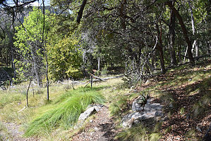
Short Ash Trail by markthurman53   CHIRICAHUA MOUNTAINS CHIRICAHUA MOUNTAINSThe Chiricahua Mountains are located in far southeast Arizona on the New Mexico and Mexico border. This mountain is probably the remotest of the over 9000 feet high sky island ranges. The closest towns are Wilcox, 40 miles to the north, and Douglas, about the same to the south. No paved roads enter this range except a short portion on the east side of the range near Portal, Arizona, and there isn’t any easy way to get there. One dirt road traverses the range from the west side near the Chiricahua Monument and ends at Portal. The remoteness makes for great hiking if you prefer solitude. With a few exceptions, many of the trails are in poor condition, ravaged by the Rattlesnake fire in 1994 and the Horseshoe 2 fire of 2011. If you are into route finding, then this is the place to hike. ASH SPRING TRAIL #247A
The Ash Spring Trail #247A is a 0.6-mile trail that connects the Herb Martyr campground to the Basin Trail #600. The trailhead is along the Herb Martyr Road or Forest Road 42A at the Herb Martyr Camp Ground. The endpoint is at the Basin Trail #600 at Ash Spring. This trail follows lower Cima Creek with its forest of sycamores, cypress, and pine with ash near the spring. Ash Spring is a perennial spring that was also the sight of a homestead. This is more of a connector trail for those heading to Greenhouse Trail #248. If your intent is the Greenhouse Trail, there is a 4WD road that leads right to the Greenhouse Trailhead in Greenhouse Canyon. This road is about 0.25 miles back north along FR42A. Description The unsigned Ash Spring trailhead is along the west side of the Herb Martyr Campground loop road. The trail has a gradual 300-foot climb along the north side of Cima Creek through a mostly pine and Cypress cover. The trail is not signed at either end but is easy to follow, though probably not maintained. At 0.6 miles in is Ash Spring, this is a perennial spring with a riparian area that hosts a meadow of grasses with some large ash trees. The wood remains of a homestead are still visible here but not much to see. The Ash Spring Trail ends at the spring where it connects up with the Basin Trail #600 as it passes through north to south. There are no good views of Winn Falls from this trail (the only good view of the falls is from the Greenhouse Trail), This trail makes for a good connector trail to the Basin Trail or a short loop hike from the campground using the southern end of the Basin and Herb Martyr Trails. Check out the Official Route and Triplogs. Leave No Trace and +Add a Triplog after your hike to support this local community. One-Way Notice This hike is listed as One-Way. When hiking several trails on a single "hike", log it with a generic name that describes the hike. Then link the trails traveled, check out the example. | |||||||||||||||||||||||||||||||||||||||||||||||||||||||||||||||||||||||||||||||||||||||||||||||||||||||||||


