 Route Editor

| Guide | ♦ | 25 Triplogs | 1 Topic |
details | drive | permit | forecast | 🔥 route |
stats |
photos | triplogs | topic | location |
| 249 | 25 | 1 |
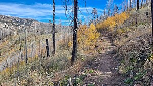
 History HistoryFort Grant, which anchors the desert end of the Grant Goudy Ridge Trail, had its heyday during the last few decades of the nineteenth century as an outpost in the wars between the U.S. Army and the Apaches. It was abandoned in 1905 and eventually reopened as an Arizona State Prison Facility, which it remains today. Historically, soldiers used the Grant Goudy Trail to move to cool refuges in the mountains and escape from the intense heat of their remote desert outpost. Hike Grant Goudy Ridge Trail follows an old pack trail from Soldier Creek Campground down the southwest slopes of the Pinalenos to historic Fort Grant. As it snakes down the ridge that separates Grant and Goudy Canyons, the trail leads from the cool forests of the mountain range's highest slopes, through a transition zone of ponderosa pine forests and oak/juniper woodlands, to a desert landscape on the floor of the Sulphur Springs Valley. Because this trail passes through so many different life zones, it is an excellent place to see a variety of wildlife including white-tailed deer, Abert squirrels, black bear among the pines, and mountain lions (if you're very lucky), coatimundi, javelina, skunk and rock squirrels at lower elevations.
Source: Coronado National Forest Check out the Official Route and Triplogs. Leave No Trace and +Add a Triplog after your hike to support this local community. One-Way Notice This hike is listed as One-Way. When hiking several trails on a single "hike", log it with a generic name that describes the hike. Then link the trails traveled, check out the example. | |||||||||||||||||||||||||||||||||||||||||||||||||||||||||||||||||||||||||||||||||||||||||||||||||||||||||||||||||||||||||||||||||||||||||||||||||||||||||||||||||||||||||||||||||||||||||||||||||


