 Route Editor

| Guide | ♦ | 3 Triplogs | 0 Topics |
details | drive | permit | forecast | 🔥 route |
stats |
photos | triplogs | topics | location |
| 77 | 3 | 0 |
History up and down by chumley   Overview OverviewThis historic old road begins at the base of the northern slopes of Mt. Graham near Pima and connects to Ash Creek Trail #307 just below the falls. The first six miles are dreadfully bland, shadeless, hot, and boring on a rocky old jeep road. The final two and a half miles are steep but offer some nice mountain terrain, shade, creek drainages, and relics of the historic old lumber tramway. Though the description below outlines the hike from the bottom to the top, most will probably prefer to hike this from the top as an out and back, avoiding the bottom 6 miles altogether. Details The hike begins where FR 35 forks away from FR 681, though you are on State Trust Land rather than Coronado National Forest land at this point. An old signpost stands at the junction but the trail sign no longer exists. There are no signs indicating that the road is closed to motor vehicles at any point on this hike so if you want to try and cut some of the mileage off, it appears to be legal to do so. However, I should warn you that the road is increasingly unpleasant and I can't imagine any enjoyment traveling this road for more than a mile even in an OHV. With that said, the first 0.4 mile crosses smooth sandy terrain and any vehicle should be able to do this section. Once the road crosses the first wash, it deteriorates quickly.
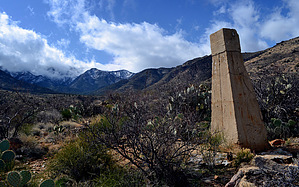
At the 6-mile mark, the road drops into the drainage once again (likely dry here) and crosses back to the west side where an unmarked trail heads west to the nearby Hulda Gap -- the location of the original namesake shingle mill. Heading upstream, the trail crosses the creek again at Horse Camp at 6.25 miles and begins to climb up the suddenly steeper slopes of the Pinaleños. At the 7 mile mark, the trail passes by the remnants of one of the tramway towers. The next half mile is relatively flat before crossing Shingle Mill Canyon once again and then making the steep final grind up the last mile and thousand feet to the junction with the Ash Creek Trail. This last mile is quite overgrown and requires quite a bit of work to fight through the growth, which now includes small trees. Despite the overgrowth, the trail is still easy to follow due to the well-constructed roadbed cut into the hillside. Water Sources The bottom six miles of this hike are dry. Parts of the upper stretches of Shingle Mill Canyon will have perennial water, but the locations of surface water and amounts will vary greatly by season. Camping The lower 6 miles are rocky and have no opportunities for camping. The upper 2.5 miles are steep and have rare opportunities for camping, though there are a few areas above the creek crossings where it is obvious that others have camped before. There is a site on the ridge just below the Ash Creek Trail junction. History Perhaps the most compelling reason to hike this trail is the rich history of this area. This entire trail consists of a road that was built over 7 years in the late 1910s. The original road was 12 miles in length and used to supply the lumber mill in the upper Ash Creek drainage near old Columbine. The challenge of the lumber mill was getting the 8 to 10 thousand board-feet of lumber produced daily off the mountain and transported to Globe where it was sold on the market. In the 1910s, a flume was constructed to float lumber down the Ash Creek drainage. The flume was so poorly constructed that to this day lumber can be found in the drainage where it had been ejected from the flume and hurled across the forest at high speed! Another feat of engineering was a 7.5-mile long tramway that was completed in 1923. It featured 90 or more wooden towers and ran under its own power (by gravity). Remnants of this tramway exist today along this route. It was constructed with equipment from abandoned mines that used similar tramways to carry ore, but over much shorter distances than this. Like the flume before it, the tramway was constructed with some dubious engineering and was subject to numerous breakdowns, and was so inefficient that it operated for only one year before being dismantled in 1924. Several people were killed by the mill, tram, and flume during this period as accidents were frequent. Much of the history mentioned above is sourced from online sources. For firsthand stories and detailed information about the tramway and the history of the flume and lumber mill, search the "Mt Graham Aerial Lumber Tramway" to read the extensive research of Don Lancaster who has published a wealth of information on the subject. At the time of this posting, his research could be found at www.tinaja.com, but web links expire over time so a web search may be more useful. Gate Policy: If a gate is closed upon arrival, leave it closed after you go through. If it is open, leave it open. Leaving a closed gate open may put cattle in danger. Closing an open gate may cut them off from water. Please be respectful, leave gates as found. The exception is signage on the gate directing you otherwise. Check out the Official Route and Triplogs. Leave No Trace and +Add a Triplog after your hike to support this local community. One-Way Notice This hike is listed as One-Way. When hiking several trails on a single "hike", log it with a generic name that describes the hike. Then link the trails traveled, check out the example. | ||||||||||||||||||||||||||||||||||||||||||||||||||||||||||||||||||||||||||||||||||||||||||||||||||||||||||


