Route Editor

| Guide | ♦ | 72 Triplogs | 0 Topics |
details | drive | permit | forecast | route |
stats |
photos | triplogs | topics | location |
| 1k | 72 | 0 |
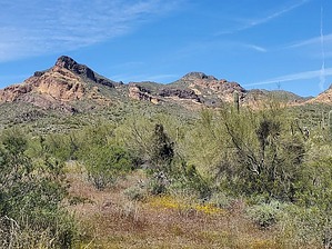
official high point of the Goldfield mountains by Mike_W  Overview Overview3381 surfaced on HAZ as a bushwhack. This is now an enjoyable hike in the Goldfield mountain range that follows a 4x4 road and then a good trail to a summit that offers 360 views of the surrounding area. Along the way, you'll see some nice rock formations, canyon views, and views of nearby mountains such as the Superstitions and Weaver's Needle. Starting from where I started at 1.2 miles up the road from the Wolverine gate, the hike would be 4.6 miles roundtrip, and you will need a high clearance 4x4 vehicle and get the Bulldog Canyon permit (see directions) if starting from this point. Beginning at the Wolverine gate would add 2.4 miles roundtrip for a total of roughly 6.3 miles and you would be fine with a regular vehicle.
From the area where I parked, FS 1356 turns and heads East. You will want to look for an unmarked 4x4 road heading Northwest. Within a few hundred feet you'll see a small wash crossing. Continue on this road for roughly 1 mile and look for a distinct trail heading off to the right and continuing UP. You'll see a section that goes through some teddy bear cholla and the trail will continue along the right side of a deep canyon. The trail is pretty easy to follow and there are some cairns along the way to help. After hiking a total of 1.6 miles you will eventually reach a saddle. At this saddle, you will see a trail branch heading West which goes to Dome Mountain. It may be a little difficult to see where you're going from here, but the peak is in the back. There will be a rocky butte in front of you and the trail goes around the right side of this butte. After hiking around the butte, you will be higher up and you will have a better view at the summit. You'll reach a small saddle with cliffs on the South side. You can admire the views from here. The trail gets a bit steeper going to the summit, but there's nothing more than class 2 hiking. I got a little off the trail 1 or 2 times, but just look for cairns and remember that if it looks dangerous to proceed, you're probably going the wrong way. Eventually, you will make it to the summit. Here, you will find a rock pile and an ammo can with a registry. You will also have nice 360-degree views all around. Take the same route down. I did this hike in early April and I saw many wildflowers and interesting plants including all of the various types of desert cactus (of course), orange globemallow, brittlebush, poppies, wolfberry, red salvia or firecracker bush, New Mexico plumeseed, cream cups, chalk dudleya, miner's lettuce, rockcress, saxifrage-pink, lanceleaf liveforever, Eaton's penstemon (red), Florida hopbush, stinknet and/or bachelor's button, Indian paintbrush, red maids, purple sandwort, Coulter's lupine, and more. From what I understand, stinknet is considered an invasive non-native plant that is found in this area. Gate Policy: If a gate is closed upon arrival, leave it closed after you go through. If it is open, leave it open. Leaving a closed gate open may put cattle in danger. Closing an open gate may cut them off from water. Please be respectful, leave gates as found. The exception is signage on the gate directing you otherwise. Check out the Official Route and Triplogs. Leave No Trace and +Add a Triplog after your hike to support this local community. | ||||||||||||||||||||||||||||||||||||||||||||||||||||||||||||||||||||||||||||||||||||||||