Route Editor

| Guide | ♦ | 14 Triplogs | 1 Topic |
details | drive | no permit | forecast | 🔥 route |
stats |
photos | triplogs | topic | location |
| 247 | 14 | 1 |
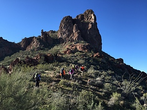
Bathed in smiles and fine dust by joebartels   Overview OverviewRugged off-trail summit hike with views of the Superstition Wilderness and Picketpost Mountain. Explore the playground mule deer, desert bighorn sheep, and javelina call home. Prologue You do not need to haul a backpack and filter water, pump iron chugging protein shakes, or run marathons to explore the rugged Superstitions. Bouncing along, en route to the designated wilderness through Hewitt Canyon, Roblas Butte has undoubtedly been placed on someday lists since one of the first paved highways in Arizona is nearby.
Long pants will likely increase your speed. Shorts or lederhosen will suffice if you are careful. Hike Beginning from a space to park immediately after crossing Peacock Creek take the path of least resistance through the mesquite bosque to the sandy wide wash of Hewitt Canyon. The route to the top is arbitrary. Current satellite imagery paints an illusion of simply weaving around bushes. Add in steep, loose footing with cacti and moderate route finding. The predominant shrub is friendly/dependable jojoba and can be used to steady your balance. Halfway up from Hewitt wash to the saddle goes by quickly. The second half deals with more brush, route finding, and foot placement in areas. Just below and above the saddle you get a few strides of relief. The initial slot to the top that comes into view looks like a bucket full of pain based on Barrett's view from nearby 3,048. The wider and reasonable-grade slot to the east appears to be the choice. Heading up the east slot you do get close to saguaro, barrel cactus, and Teddy-bear Cholla, but are avoidable with careful foot-placement. Continue up the path of least resistance. Rock scrambling is minimal and easy if you are on the easiest route. When you reach the top, a 300+ drop off the edge is yards away. Summit ridge as Barrett described it is fitting. The butte that catches your eye to the northwest is Buzzards Roost [ zoom ]. The slanting high point, three summits to the right of Buzzard, is Fraser Peak [ zoom ]. There is a register about 20 feet to the north. Be careful near the edge and return by the same route or explore other variations and nearby high points. Synopsis Lack of balance and inability to catch a fall is my kryptonite. Others find it a moderately quick and intimate sojourn up a dabbled blob of Superstition geology. Staying near the posted Official Route is certainly the shortest and most used option. A scary southwest slanted ravine may or may not be doable. A longer south-southwest approach does not appear better than the above based on satellite. I only encountered and pushed aside one catclaw bush on the edge of Hewitt wash so it must have been a great day! Nearby Adventuring Elephant Arch is worthy since it's only 1.3 miles up the road and 1-mile Roundtrip. Byous Butte is further, more gnarly and less teeny-bopper (Tik Tok y). 44-second Video
Check out the Official Route and Triplogs. Leave No Trace and +Add a Triplog after your hike to support this local community. | |||||||||||||||||||||||||||||||||||||||||||||||||||||||||||||||||||||||||||||||||||||||||||||||||||||||||||||||||||||||||||||||||||||||||||||||||||||||||||||||||||||||||||||||||||||||