 Route Editor

| Guide | ♦ | 7 Triplogs | 1 Topic |
details | drive | permit | forecast | 🔥 route |
stats |
photos | triplogs | topic | location |
| 24 | 7 | 1 |
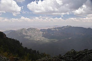
Dead end Trail with a view by markthurman53   CHIRICAHUA MOUNTAINS CHIRICAHUA MOUNTAINSThe Chiricahua Mountains are located in far southeast Arizona on the New Mexico and Mexico border. This mountain is probably the remotest of the over 9000 feet high sky island ranges. The closest towns are Wilcox, 40 miles to the north, and Douglas, about the same to the south. No paved roads enter this range except a short portion on the east side of the range near Portal, Arizona, and there isn’t any easy way to get there. One dirt road traverses the range from the west side near the Chiricahua Monument and ends at Portal. The remoteness makes for great hiking if you prefer solitude. With a few exceptions, many of the trails are in poor condition, ravaged by the Rattlesnake fire in 1994 and the Horseshoe 2 fire of 2011. If you are into route finding, then this is the place to hike. CENTELLA TRAIL #334
For travelers along the Crest Trail and for visitors to Rustler Park looking for a scenic way to spend a day, there's a trail system that leads to several interesting features, including Flys Peak, Bear Wallow Spring, Tub Spring, and scenic Centella Point. With its panoramic overlooks of the Cave Creek Basin, the trip to Centella Point is 1.7 miles long. "Centella" is the Spanish word for "thunderbolt." Be sure to notice the trees which have been struck by lightning on this exposed point. This area, which was the site of a small but hot fire in 1987, provides an excellent opportunity to observe how the forest regenerates after such a disturbance. Aspen, one of the first tree species to sprout after a fire, is growing on the north end of the ridge. Various wildflowers and grasses cover much of the fire site. Insects and birds are plentiful, and animals such as black bears seem to welcome rather than regret the meadow that has been created. Description The Centella Trail #334 trailhead is in Flys Park at the junction of 3 other trails, the Crest Trail #270, Flys Peak Trail #337, and the Long Park Trail #42D, which is the old abandon FR42D. This intersection of trails is signed, indicating each of the 4 trails. The Centella Trail heads due east across an old burn area and is now recovering with ferns and aspen. Many of the charred remains of the larger fir trees still stand, while the rest of their fallen compadres lay on the ground in various stages of decay, still a very beautiful park. The first 0.3 miles of the Centella trail is relatively level, with Tub Spring at 0.2 miles in. Flys Park and the north slopes of Flys Peak are the upper watersheds for the northern tributary of Cave Creek. At 0.3 miles, the trail starts a 250-foot climb in 0.4 miles before leveling off for the rest of the way to Centella Point. Once on top, it is reasonably easy walking along this section through a dense forest of pine and fir trees. At 0.75 miles in is the signed junction with the Bear Wallow Trail #333. The next 1 mile to Centella Point is through an old burn area that is recovering nicely. The upside of the burn area is that the views to the east are spectacular. All of Cave Creek basin, Silver Peak, Mount Sceloporus and Portal Peak are in view and on a clear day way into New Mexico. Along the trail to the point, stop and wander over to the east edge of the ridge for great views. Not positive, but in my photos, it appears that Winn falls can be seen from this trail. The trail ends on a point with views toward the north and east. Beautiful trail and worth doing whether it is a side trip on a longer hike or just a destination for a single hike. Check out the Official Route and Triplogs. Leave No Trace and +Add a Triplog after your hike to support this local community. One-Way Notice This hike is listed as One-Way. When hiking several trails on a single "hike", log it with a generic name that describes the hike. Then link the trails traveled, check out the example. | ||||||||||||||||||||||||||||||||||||||||||||||||||||||||||||||||||||||||||||||||||||||||||||||||||||||


