username
X
password
register
for free!
help
 
   🔥

Long Park Trail #42D - Chiricahua Mountains, AZ

Guide 8 Triplogs  1 Topic
  3.6 of 5  
Fav
Wish
0
details
drive
permit
forecast
🔥
route  
stats
photos
triplogs
topic
location
0 8 1
Statistics
tap row or icons for details
Difficulty 1 of 5
Route Finding 1 of 5
Distance One Way 0.7 miles
Trailhead Elevation 9,052 feet
Elevation Gain -64 feet
Accumulated Gain 100 feet
Avg Time One Way 20 minutes
Kokopelli Seeds 1.03
 Backpack Yes
unreported if dogs are allowed
editedit > ops > dogs to adjust
feature photo
Photos Viewed All MineFollowing
Will recalculate on button tap!
113  2024-06-15
Snowshed Peak - Chiricahua Wilderness
Mike_W
23  2023-05-27
Crest Trail #270A - Chiricahua Peak
chumley
15  2023-05-27
Crest Trail #270A - Chiricahua Peak
BiFrost
8  2022-05-26
Chiricahua Peak from Rustler Park TH
fricknaley
42  2021-08-11
Crest Trail #270
markthurman53
22  2021-06-27
Green House Crest Trail Loop
markthurman53
4  2020-11-15
Chiricahua & Monte Vista Peak Loop
toddak
27  2020-06-17
Chiricahuas - South Flys and Snowshed
DixieFlyer
Author
author avatar Guides 99
Routes 1,484
Photos 16,072
Trips 1,374 map ( 13,602 miles )
Age Male Gender
Location Fountain Hills, AZ
Associated Areas
list map done
Tucson Region
Historical Weather
Trailhead Forecast
Radar Map
Expand Map
Preferred May, Jun, Nov, Oct → Early
Seasons   Early Spring to Late Autumn
Sun  5:54am - 6:38pm
Official Route
 
3 Alternative
 
Historic Fire Perimetersacres
🔥 2011 Horseshoe 2 Fire158.9 mi*
🔥 1994 Rattlesnake Fire50.4 mi*
🔥 View (All) - over Official Route 🔥
*perimeter length in miles


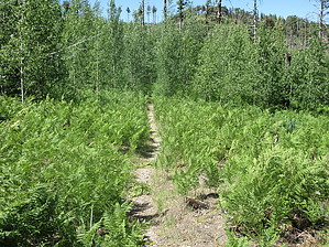
A short but useful trail
by DixieFlyer

 
Overview
Hiking Long Park Trail #42D is the shortest way to get to Flys Peak and Chiricahua Peak.


Hike
From the trailhead, the trail heads southwest for 0.7 miles to Fly Saddle. Fly Saddle is a 5-way junction with Crest Trail 270, which goes in two different directions, Flys Peak Trail #337, and Centella Trail #334.
remove free decal offer
Shortly after leaving the trailhead, the trail goes into the Chiricahua Wilderness.

The trail is in good condition and easy to follow; however, you might brush up against some ferns that encroach on the trail in the summertime.

This area burned in the Horseshoe 2 fire in 2011; however, some large pine trees still remain. There are also some stands of aspens that are growing in the aftermath of the fire.

Don't be surprised to see some wildlife while hiking on this trail -- the author of this guide has seen bear, deer, and turkey in the area.

Synopsis
This trail offers a good alternative to the Rustler Park Trailhead and the trailheads on Turkey Creek Road to get to some of the peaks in the Chiricahua Mountains alongside and off the Crest Trail. In particular, this trail facilitates access to Flys Peak and Chiricahua Peak. However, note that you'll need a vehicle with some off-road capabilities to access the trailhead.

2020-06-18 DixieFlyer


    Check out the Official Route and Triplogs.
    Leave No Trace and +Add a Triplog after your hike to support this local community.

    One-Way Notice
    This hike is listed as One-Way.

    When hiking several trails on a single "hike", log it with a generic name that describes the hike. Then link the trails traveled, check out the example.
    WARNING! Hiking and outdoor related sports can be dangerous. Be responsible and prepare for the trip. Study the area you are entering and plan accordingly. Dress for the current and unexpected weather changes. Take plenty of water. Never go alone. Make an itinerary with your plan(s), route(s), destination(s) and expected return time. Give your itinerary to trusted family and/or friends.

     Permit $$
    None

    Coronado Forest
    MVUMs are rarely necessary to review unless mentioned in the description or directions
    Coronado Motor Vehicle Use Maps (MVUMs)


     Directions
    or
     Road
    High Clearance possible when dry

    To hike
    The trailhead is at the end of FR 42D and is two miles beyond Rustler Park. While FR 42D is a well-graded, unpaved road to Rustler Park, beyond Rustler Park the road has some rough, rocky, and steep sections. When dry a skillful driver in a high clearance vehicle with good off-road tires could possibly drive to the trailhead; however, a high clearance 4WD vehicle is recommended. GPS coordinates for the TH are 31.8864, -109.2794.

    Directions to Rustler Park are here.
    page created by DixieFlyer on Jun 18 2020 6:39 am
     90+° 8am - 6pm kills
    helpcorrectionissue

    end of page marker