 Route Editor

| Guide | ♦ | 54 Triplogs | 0 Topics |
details | drive | permit | forecast | route |
stats |
photos | triplogs | topics | location |
| 130 | 54 | 0 |
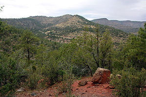
Mescal meanderer by PrestonSands  Overview OverviewConveniently located near the Mingus Summit on Highway 89A, The Bug Hollow Trail #548 is an old, closed road turned Forest Service trail that meanders along Mingus Mountain's forested slopes, eventually depositing one into Mescal Gulch. It can also be hiked in conjunction with its connecting trails: Mescal Trail #547, Upper Mescal Trail #550, Powerline Trail #549, and North Mingus Trail #105. Hiking the Bug Hollow Trail from top to bottom is easier than from bottom to top, due to the lower end being unsigned and not as easy to follow.
From its upper trailhead along Highway 89A, the Bug Hollow Trail passes through a gate next to a trail #548 signpost and heads north and downhill along a closed road into a ponderosa pine forest. The trail levels off as it circles a 6900-foot hill and soon crosses two lush drainages, the second one harboring a couple of small aspens, a rarity in these mountains. Tall pines and gambel oaks tower above as the trail enters a third drainage, that of Mescal Gulch. The trail passes signed junctions with the Mescal Trail #547 at 1.25 miles, which heads down the creek bed of Mescal Gulch, and then, a few hundred feet later, passes the Upper Mescal Trail #550, which heads up the canyon. Leaving Mescal Gulch, the Bug Hollow Trail contours north along drier slopes, where one can see Woodchute Mountain rising in the distance. At around mile 2, a signed junction with the Powerline Trail #549 is passed shortly before the Bug Hollow Trail arrives at a grassy meadow in a saddle, dominated by a large, lone juniper tree. Upon entering the grassy meadow, the Bug Hollow Trail becomes a bit more primitive, and one needs to keep an eye out for cairns and flagging tape from this point on. The trail is not difficult to follow. It's just an abrupt change from the old road you have been hiking on up until this point. The trail descends the brushy eastern slope of hill 6772, where one can look down Mescal Gulch at the Verde Valley in the distance. Clearing the 6772-foot hill, the trail descends its northeast ridge on loose limestone cobble and quickly arrives at an unexpected open, rocky, flat camping area. Follow the cairns and flagging tape across the little flat to where the trail joins the route of a four-wheel-drive road. This road descends the hillside, curving west, and arrives at a road fork in a shallow ravine. Take the right fork, which heads downhill, and you will reach Forest Road 338 at the bottom of Mescal Gulch in 0.25 miles. The Bug Hollow Trail ends here and is not marked as of this writing. Heading east on Forest Road 338 will bring you to the North Mingus Trail #105 while heading west brings you to the signed junction with the Mescal Trail #547 in 0.2 miles. Highway 89A is just a few hundred feet beyond that. The Mescal Trail makes an excellent return hike option, shaving off a bit of distance and taking you through a shady canyon environment. Gate Policy: If a gate is closed upon arrival, leave it closed after you go through. If it is open, leave it open. Leaving a closed gate open may put cattle in danger. Closing an open gate may cut them off from water. Please be respectful, leave gates as found. The exception is signage on the gate directing you otherwise.
Check out the Official Route and Triplogs. Leave No Trace and +Add a Triplog after your hike to support this local community. One-Way Notice This hike is listed as One-Way. When hiking several trails on a single "hike", log it with a generic name that describes the hike. Then link the trails traveled, check out the example. | ||||||||||||||||||||||||||||||||||||||||||||||||||||||||||||||||||||||||||||||||||||||||||||||||||||||||||||||||||||||||||||||||||||||||||||||||||||||||||||||||||||||||||||||||||||||||||||||||||


