Overview
The views from this long trail are spectacular. Most impressive is the general view of the extremely rugged country extending below the rim to the Verde River. You can also see the Mazatzal Mountains to the east, Four Peaks to the south, and the Bradshaw Mountains to the west. Verde Rim Trail #161 is reasonably level, traversing along the edge of its namesake landmark for most of its length. The final ascent to Pine Mountain, however, is steep and rugged.
As of May 2011, the section of Trail #161 that lies between Willow Springs Trail #12 and Pine Mountain Trail #14 is in good condition. However, the remainder of the trail is rocky, overgrown, and difficult to find and follow. This is especially true south of Pine Mountain, where the trail passes through a burned area.
When hiking several trails on a single "hike", log it with a generic name that describes the hike. Then link the trails traveled, check out the example.
WARNING! Hiking and outdoor related sports can be dangerous. Be responsible and prepare for the trip. Study the area you are entering and plan accordingly. Dress for the current and unexpected weather changes. Take plenty of water. Never go alone. Make an itinerary with your plan(s), route(s), destination(s) and expected return time. Give your itinerary to trusted family and/or friends.
Only trailheads with six "amenities" have fees. Amenities are picnic tables, trash, toilet, parking, interpretive signing and security.
Directions
Road
To hike Beginning at I-17, take Dugas Exit #268. Turn right onto Dugas Road (also FR 68) and travel 6.7 miles to the Dugas homestead. Continue on FR 68 for another 2.3 miles to a fork in the road. Bear right to remain on FR 68 and go 1.8 miles to the junction with FR 68G. Proceed straight at the intersection and take FR 68G east for 10 miles. You will pass Trail #27 on the left before arriving at the trailhead. Parking is poor. FR 68G is suitable for high clearance, 4WD vehicles only, and portions may be impassable. FR 68 is graded dirt. A high clearance vehicle is recommended. 4WD may be necessary when the road is wet.
As of May 2011, FR 68G is in poor condition. It is suggested that Trail #161 be accessed via Trail #159. To reach the Trail #159 trailhead, follow the directions above to the intersection with FR 68G. Turn right at this intersection to remain on FR 68 and continue 6.9 miles to Salt Flat Campground and the trailhead for Trail #71 and Trail #159. There is parking for 5-10 vehicles.
page created by joebartels on Nov 15 2012 12:18 am
 Route Editor


 Overview
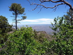


