 Route Editor

| Guide | ♦ | 29 Triplogs | 1 Topic |
details | drive | permit | forecast | 🔥 route |
stats |
photos | triplogs | topic | location |
| 0 | 29 | 1 |
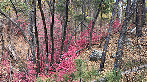
  This high elevation trail is a connector trail linking other longer trails that provide access to the Pine Mountain Wilderness Area, Pine Mountain itself, and the Verde Rim. There are magnificent panoramic views from this rim of the upper Verde basin, the red rock cliffs above Sedona, even Four Peaks in the Mazatzal Mountains east of Phoenix, and the Superstition Mountains. The vegetation in this area is mainly ponderosa pine. However, the approach to the Verde Rim climbs through an attractive riparian bottom with small stands of aspen, maple, and evergreen and deciduous oaks. It is not unusual to encounter white-tailed deer, mule deer, javelina, and, though seldom seen, signs of elk. Black bear are also common in this area. The trail connects with Nelson Trail #159, and Verde Rim Trail #161 thus providing the opportunity to make a round-trip hike or ride in the Pine Mountain area. This high elevation trail is a connector trail linking other longer trails that provide access to the Pine Mountain Wilderness Area, Pine Mountain itself, and the Verde Rim. There are magnificent panoramic views from this rim of the upper Verde basin, the red rock cliffs above Sedona, even Four Peaks in the Mazatzal Mountains east of Phoenix, and the Superstition Mountains. The vegetation in this area is mainly ponderosa pine. However, the approach to the Verde Rim climbs through an attractive riparian bottom with small stands of aspen, maple, and evergreen and deciduous oaks. It is not unusual to encounter white-tailed deer, mule deer, javelina, and, though seldom seen, signs of elk. Black bear are also common in this area. The trail connects with Nelson Trail #159, and Verde Rim Trail #161 thus providing the opportunity to make a round-trip hike or ride in the Pine Mountain area.Maps, other resources: Prescott National Forest, east half; U.S.G.S. topographic 7.5' quad for Tule Mesa.
The trail begins at its intersection with TR #159 just below Willow Spring. It climbs steadily and, for most of its length, through a riparian bottom to the Verde Rim. The elevational change is only 750 feet, though this change occurs in only 1.6 miles. The trail intersects with the Verde Rim Trail #161, just about 0.5 miles below Pine Mountain. Precautions As with most of the Prescott National Forest trails, water sites such as Willow Spring and Pine Spring are undependable, and travelers should carry plenty of drinking water. Check out the Official Route and Triplogs. Leave No Trace and +Add a Triplog after your hike to support this local community. One-Way Notice This hike is listed as One-Way. When hiking several trails on a single "hike", log it with a generic name that describes the hike. Then link the trails traveled, check out the example. | ||||||||||||||||||||||||||||||||||||||||||||||||||||||||||||||||||||||||||||||||||||||||||||||||||||||||||||||||||||||||||||||||||||||||||||||||||||||||||||||||||||||||||||||||||||||||||||||||||||||


