 Route Editor

| Guide | ♦ | 18 Triplogs | 1 Topic |
details | drive | permit | forecast | 🔥 route |
stats |
photos | triplogs | topic | location |
| 253 | 18 | 1 |
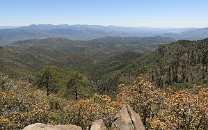
Pine trees not included by nonot   Warning WarningThis area is still attempting to recover from wildfires. Be aware of falling snags. Overview A short connector trail between Nelson Trail and Verde Rim Trail.
From the Cloverleaf saddle area leave Nelson Trail #159 and take the turn uphill to the east/southeast at the Pine Mountain Trail sign. At this point, you will be standing amongst blackened standing dead pine trees, which I assume are remnants of the Cave Creek fire or perhaps a more recent lightning strike. You will proceed uphill, generally headed east, along the north side of a ridge for about a half mile. The views are pretty good to the north. About halfway up the trail the trail follows a minor saddle with a small jog south and will continue up the crest of the ridge to the east the remaining distance to the top. Views to the south open up here, and you will encounter more live trees the further uphill you go. At the end the Pine Mountain trail tees into the Verde Rim Trail #161. Pine Mountain itself is roughly a half mile to the north with the summit itself being a short off-trail but easy scramble. As you have reached the rim, the views into the Mazatzals from the end of the trail off to the east are pretty good and you can see several central Arizona mountain ranges and wilderness areas, including Hellsgate Wilderness slightly to the south on a clear day. Overall the connector trail is a fairly steady uphill grade but the views are worthwhile such that many hikers should consider including this trail in a larger loop trip of the Pine Mountain Wilderness. Water Sources No water sources are known to exist anywhere near the trail. Camping No real options along the trail, and due to the state of trees at the saddle I wouldn't recommend planning to camp near the start of the trail either. There are some opportunities for camping along Nelson Trail further North of the start point, or dry camping options along the Verde rim trail at several points near the end of the trail. Check out the Official Route and Triplogs. Leave No Trace and +Add a Triplog after your hike to support this local community. One-Way Notice This hike is listed as One-Way. When hiking several trails on a single "hike", log it with a generic name that describes the hike. Then link the trails traveled, check out the example. | ||||||||||||||||||||||||||||||||||||||||||||||||||||||||||||||||||||||||||||||||||||||||||||||||||||||||||||||||||||||||||||||||||||||||||||||||||||||||||||||||||||||||||||||||||||||||||||||||||||||||||||


