username
X
password
register
for free!
help
  This is likely a great time to hike this trail!  Check out "Preferred" months below, keep in mind this is an estimate.
  

Red Mountain Trail #43 - Prescott NF, AZ

Guide 7 Triplogs  0 Topics
  3.7 of 5  
Fav
Wish
1
details
drive
permit
forecast
route  
stats
photos
triplogs
topics
location
113 7 0
Statistics
tap row or icons for details
Difficulty 2.5 of 5
Route Finding 1 of 5
Distance One Way 1.8 miles
Trailhead Elevation 6,245 feet
Elevation Gain -763 feet
Accumulated Gain 85 feet
Avg Time One Way 1-1.5 hours
Kokopelli Seeds 2.08
feature photo
Photos Viewed All MineFollowing
Inaugural Calculation on Button Tap!
16  2025-04-13
Bear Down Mountain
astrobrewer
18  2025-04-02 mt98dew
25  2024-10-27
Stoneridge 6542 - Bear Down - Sun Devil Loop
John10s
17  2021-01-15 TheHikingGolfer
3  2020-10-22 Sun_Ray
32  2020-05-02 joebartels
18  2017-06-17
Stoneridge Peak 6542
Peter_Medal
Author
author avatar Guides 264
Routes 2,797
Photos 14,494
Trips 5,894 map ( 29,783 miles )
Age 55 Male Gender
Location
Associated Areas
list map done
Prescott Region
Historical Weather
Trailhead Forecast
Radar Map
Expand Map
Preferred Oct, May, Apr, Sep
Sun  6:04am - 6:52pm
Official Route & 1 Rt
 
4 Alternative


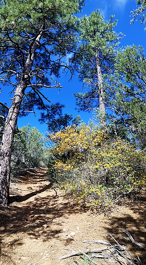
Evergreen Oaks to Tall Pines
by joebartels

  Likely In-Season!
Overview
Runs between Charcoal Gulch Trail #9419 on the lower end up to the middle of Prospector Trail #42.


Hike
Red Mountain Trail #43 begins after 0.95 mi on Charcoal Gulch Trail #9419. The scenery changes quickly as you enter a forest of Arizona White Oaks. Unfortunately, my favorite oak segment is over near or soon after a gate at 0.5 miles. The trail continues up Green Gulch at a leisure grade to "the" switchback around 0.82 miles. The sweet oaks are over and junipers take over.
remove free decal offer
The tread gets rocky and steep on both sides of a gate at 1.3 miles. Peakbaggers should consider a jaunt up to Stoneridge Peak 6542 from the gate. I'm guessing the Forest Service calls peak 6,542 Red Mountain since it is red from the south.

My second favorite section is about 1.4 miles up. There are a couple of areas with nice views back down and across to Sun Devil Peak.

The trail is easy hiking to tall pines around Trail Tank @ 1.55 miles. Then ends at a junction with Prospector Trail #42 at 1.8 miles.

Synopsis
OHV trails aren't for everyone. I likely enjoyed this trail more than most but think most hikers will find it worthy once in nice weather.

Gate Policy: If a gate is closed upon arrival, leave it closed after you go through. If it is open, leave it open. Leaving a closed gate open may put cattle in danger. Closing an open gate may cut them off from water. Please be respectful, leave gates as found. The exception is signage on the gate directing you otherwise.

2020-05-05 joebartels


    Check out the Official Route and Triplogs.
    Leave No Trace and +Add a Triplog after your hike to support this local community.

    One-Way Notice
    This hike is listed as One-Way.

    When hiking several trails on a single "hike", log it with a generic name that describes the hike. Then link the trails traveled, check out the example.
    WARNING! Hiking and outdoor related sports can be dangerous. Be responsible and prepare for the trip. Study the area you are entering and plan accordingly. Dress for the current and unexpected weather changes. Take plenty of water. Never go alone. Make an itinerary with your plan(s), route(s), destination(s) and expected return time. Give your itinerary to trusted family and/or friends.

     Permit $$
    no fees or permits reported

    if incorrect tell us about it

    Prescott Forest
    Prescott National Forest Pass

    Only trailheads with six "amenities" have fees. Amenities are picnic tables, trash, toilet, parking, interpretive signing and security.


     Directions
    or
     Road


    To Green Gulch Trailhead
    TH is the terminus of Newtown Ave on the edge of Dewey-Humbolt and large enough for many trailers. Trails from this TH are OHV designated. Trail #9419 starts at the domed ATV Cattle Guard.

    0) Dewey-Humbolt 0.68 mi N on 69 from 169/69 (Mortimer Farms is SE)
    1) Kachina Pl → 0.4 mi
    2) Continue on Horseshoe Ln → 0.1 mi
    3) Left on S Pony Pl → 495 ft
    4) Right on Henderson Rd → 2.1 mi
    5) Continue on Newtown Ave → 1.1 mi

    Huge lot for cars and trailers.

    From PHX (I-10 & AZ-51) - 2 h 5 min (109 miles)
    From TUC (Jct 1-10 & Grant) - 3 h 32 min (214 miles)
    From FLG (Jct I-17 & I-40) - 1 h 55 min (97.5 miles)
    page created by joebartels on Nov 17 2012 12:02 am
     90+° 8am - 6pm kills
    helpcorrectionissue

    end of page marker