 Route Editor

| Guide | ♦ | 11 Triplogs | 1 Topic |
details | drive | no permit | forecast | 🔥 route |
stats |
photos | triplogs | topic | location |
| 285 | 11 | 1 |
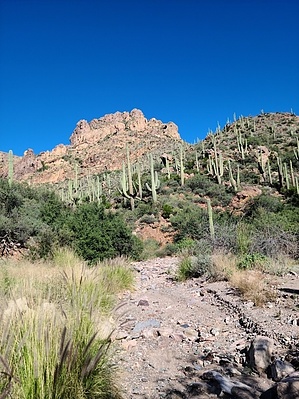
Joey Gumdrop's Backyard by joebartels   Overview OverviewMillsite Canyon Trail #237 has never been a maintained hiking trail in the nearly thirty years it has popped up on my radar. Rather an old jeep road through a slice of Sonoran heaven few hikers ever hike. Getting to the canyon without 4WD probably keeps out a fair share of curious hikers. Upper signage declares Closed to Motorized Vehicles and Motorized Equipment. Lower signage lacks the verbiage, perhaps peeled off as it is missing that section. Regardless, it is a semi-popular destination for offroaders as is the entire area south of the nearby designated Superstition Wilderness.
From the south, at the topo map end of FR1900, begin hiking up #237. Views begin immediately and stay intriguing for the first 2.5 miles to the former Maverick Camp. Huge Fremont Cottonwoods come soon, along with red toned rock creekbeds reminiscent of nearby Randolph Canyon if you explore off-trail to keep your social media adventure username true to spirit. The most notable geology looming overhead is Fraser Peak 4618 near 2 miles up. Fraser Peak is a worthy destination in itself due to the great views and one of two arches along this hike. 2.9 miles onward is within the 2019 Woodbury Fire perimeter. The difference is minimally evident being rolling hills of junipers vs the lower broadleaf riparian areas. The area sports nice examples of Desert Hackberry, no surprise with nearby Hackberry Butte and a similar named canyon and spring off its southside. If you happen by when the orange berries are ripe they are worth a sample. Beware, they're 75% seed but have a refreshing fruit flavor that fades quickly like Trident gum. Twins Upper Rattlesnake Spring (Iron Mountain topo) is near Maverick Camp and lower Rattlesnake Spring (Picketpost Mountain topo) is near the beginning of the hike at 1 mile. Upper Millsite Less obvious gems reside in the upper canyon that will not appeal to most. Arizona Sycamores before upper Rattlesnake Spring are the last riparian-esque hurrah but healthy pleated saguaros stay strong in areas until the old route eases up to a stroll from 2.6 to 4.6 miles. Oblivian At 4.6, the trail turns north off the well-defined two-track to an older and nearly faded-away route to FS172 near Woodbury Trailhead. It's obvious to 5.0 miles. The balance of 0.3 miles is neither easy to see nor possible for some as it is washed out to untraceable for a good hundred yards. A barbed wire fence line in nearby eyesight will suffice for your route. It's unlikely you'll get back on the old official route again but it does not matter where you pop out on FS172. There is no signage or hints along FS172 that this trail is/was ever an option. Synopsis Millsite is more of a gem than meets the eye. The lower half will get the lion's share of attention. In full, it is surrounded by perks and loded with dreams. The offroad crowd has never been an issue in my experiences out here or around the rowdy Four Peaks. Typically low gear crawling in Millsite as it is not a racetrack. They make it easier to get through in half a day. Shooting dwindles out this far but it is not uncommon. Most encounters lean towards extremely relaxed and friendly. 51-Second Video Check out the Official Route and Triplogs. Leave No Trace and +Add a Triplog after your hike to support this local community. One-Way Notice This hike is listed as One-Way. When hiking several trails on a single "hike", log it with a generic name that describes the hike. Then link the trails traveled, check out the example. | |||||||||||||||||||||||||||||||||||||||||||||||||||||||||||||||||||||||||||||||||||||||||||||||||||||||||||||||||||||||||||||||||||||||||||||||||||||||||||||||||||||||||||||||||||||||||||||||||||


