 Route Editor

| Guide | ♦ | 38 Triplogs | 0 Topics |
details | drive | permit | forecast | route |
stats |
photos | triplogs | topics | location |
| 0 | 38 | 0 |
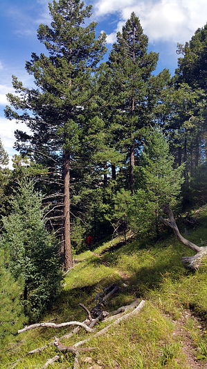
  Patrick Scott was one of many prospectors who spent a good part of their lives searching for mineral riches in the Huachuca Mountains. Scott eventually filed a claim called The Wisconsin in an area drained by the headwaters of Ramsey Canyon. For that reason, we know the two main tributaries of that major Huachuca Mountains drainage as Pat Scott and Wisconsin canyons. The Pat Scott Trail leads up the larger of these, which many consider an extension of the main canyon; the streamside habitat it supports is just as lush and nearly as full of birdlife as in Ramsey Canyon. Patrick Scott was one of many prospectors who spent a good part of their lives searching for mineral riches in the Huachuca Mountains. Scott eventually filed a claim called The Wisconsin in an area drained by the headwaters of Ramsey Canyon. For that reason, we know the two main tributaries of that major Huachuca Mountains drainage as Pat Scott and Wisconsin canyons. The Pat Scott Trail leads up the larger of these, which many consider an extension of the main canyon; the streamside habitat it supports is just as lush and nearly as full of birdlife as in Ramsey Canyon.The hiking is just as pleasant, too. Habitats do change with elevation, however, and you'll get a chance to observe that change as you continue climbing from the Hamburg Trail #122/Pat Scott Trail junction. The canyon becomes steeper and more narrow as it climbs, and riparian plants give way to species we associate more readily with highlands than streambeds. In the upper reaches of Pat Scott Canyon, you'll also get a chance to observe the extensive damage that can result if mountain slopes are stripped of vegetation. A fire that removed many of the trees and much of the understory from this area in 1983 was followed by a flash flood that roared down the canyon like a bulldozer. That torrent increased the depth of the streambed as much as eight feet in some places and stripped the banks of trees and shrubs. Considerable damage was done to trail crossings, too, but those have since been repaired.
Check out the Official Route and Triplogs. Leave No Trace and +Add a Triplog after your hike to support this local community. One-Way Notice This hike is listed as One-Way. When hiking several trails on a single "hike", log it with a generic name that describes the hike. Then link the trails traveled, check out the example. | ||||||||||||||||||||||||||||||||||||||||||||||||||||||||||||||||||||||||||||||||||||||||||||||||||||||||||||||||||||||||||||||||||||||||||||||||||||||||||||||||||||||||||||||||||||||


