 Route Editor

| Guide | ♦ | 29 Triplogs | 1 Topic |
details | drive | permit | forecast | 🔥 route |
stats |
photos | triplogs | topic | location |
| 346 | 29 | 1 |
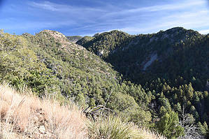
Ridge Trail with a Confusing Ending by markthurman53   CHIRICAHUA MOUNTAINS CHIRICAHUA MOUNTAINSThe Chiricahua Mountains are located in far southeast Arizona on the New Mexico and Mexico border. This mountain is probably the remotest of the over 9000 feet high sky island ranges. The closest towns are Wilcox, 40 miles to the north, and Douglas, about the same to the south. No paved roads enter this range except a short portion on the east side of the range near Portal, Arizona, and there isn’t any short way to get there. One dirt road traverses the range from the west side near the Chiricahua Monument and ends at Portal on the east side. There are two dirt roads on the west side; Turkey Creek and Rucker Canyon allow access to the west side trails. The remoteness makes for great hiking if you prefer solitude. Many of the trails are in poor condition with a few exceptions, ravaged by the Rattlesnake fire in 1994 and the Horseshoe 2 fire of 2011. If you are into route finding, then this is the place to hike. MORMON RIDGE TRAIL #269
The Lower end of the Mormon ridge Trail #269 is along Turkey Creek Road FR41, just past Saulsbury turnoff. Its upper end is along the Crest Trail #270B near Chiricahua Saddle. Unlike Mormon Canyon Trail #352, this trail is in pretty good condition. This trail follows along a ridge that separates Mormon Canyon from Ward Canyon and continues up toward Chiricahua Saddle on the southwest side of Chiricahua Peak. The Mormon Ridge Trail does not follow along the crest of the ridge but just below on the south side, and because of this, it can be a bit warm. Great views overlook Mormon Canyon. This is a fairly steep trail with about 3000 feet of AEG, taking you from Oak, Juniper forests to Ponderosa and Fir Tees. Many loop hikes along the west side of the Chiricahua Mountains can be made using this trail as one of the legs. Everyone agrees as to where the lower end of the Mormon Canyon Trail #352 and the Mormon Ridge Trail #269 is, but there is some confusion as to where these trails end. The Forest Service website says the Mormon Ridge Trail heads up to Mormon Saddle, then heads north to The Crest Trail #270 just south of Cima Park, and the Mormon Canyon Trail from Mormon Saddle heads south to the Crest Trail #270B near Chiricahua Saddle. The actual signage says differently. The section of the Mormon Ridge trail from Mormon Saddle to Cima Park does not exist anymore, no signs at either end, in fact, no trail in between either. When I hiked that route a few years ago, there was no sign of a trail. It was a bushwhack across rocky taluses and an aspen tree log hop. I couldn’t even find any trace of where the trail leaves the Crest Trail. The current consensus (at least among those that matter) is that the Mormon Canyon Trail ends at Mormon Ridge at the Mormon Ridge Trail, and the Mormon Ridge Trail ends near Chiricahua Saddle on the Crest Trail #270B. This agrees with the signage along the trail. There may have been a trail to Cima Park at one time, but the Horseshoe 2 fire wiped it out (I’m guessing it was the Horseshoe 2 Fire, there have been a couple over the last 20 years). Description The signed Trailhead is along Turkey Canyon Road FR41, about 0.4 miles past the Saulsbury turnoff. The Mormon Ridge Trail immediately heads toward Turkey Creek (300 feet) and crosses it. Once past the Creek, the trail begins its relentless climb. It parallels Turkey Creek for the first 0.5 miles as it continues to climb up to the ridge. At 0.8 miles, it reaches a saddle on the ridge and continues its upward climb staying just below the ridge on the south side. The trail has a pretty consistent 15% grade, and in the places where the ridge heads up steeply, the trail keeps up using switchbacks. There are three sets of switchback along this trail to the junction with Mormon Canyon Trail. These sets of switchbacks, about 2 or 3 to a set, are pretty evenly spaced over a 3 mile stretch of trail to Mormon Saddle and the junction with Mormon Canyon Trail. At 3.5 miles, the trail levels off a bit at Mormon Saddle, The Mormon Canyon Trail #352 comes in from the west. There are good views from the Saddle looking down Mormon Canyon to the west, Ward and Saulsbury Canyons to the north, and Chiricahua Crest to the east. The old Mormon Ridge Trail up to Cima Park heads off somewhere from this saddle for those into a little bloodletting. The existing Mormon Ridge Trail continues from the saddle in a southeast direction at first, then south toward Chiricahua Saddle. This trail is in fair condition and easy to follow. After 0.6 miles is the signed junction with the Crest Trail #270B. This section from the saddle is heavily forested and the views limited; well, the distant views are, but the close-in ones are great. This trail has many options for loop hikes, either heading south along the Crest Trail 270B or heading north along the Crest Trail 270. Many connector trails will bring you back to close proximity of where you started: Morse Canyon Trail #43 Pole Bridge Trail #243 Saulsbury Trail #263 Rock Canyon Trail #269 Check out the Official Route and Triplogs. Leave No Trace and +Add a Triplog after your hike to support this local community. One-Way Notice This hike is listed as One-Way. When hiking several trails on a single "hike", log it with a generic name that describes the hike. Then link the trails traveled, check out the example. | |||||||||||||||||||||||||||||||||||||||||||||||||||||||||||||||||||||||||||||||||||||||||||||||||||||||||||||||||||||||||||||||||||||||||||||||||||||||||||||||||||||||||||||||||||||||||||||||||||||||||||||||||


