 Route Editor

| Guide | ♦ | 34 Triplogs | 1 Topic |
details | drive | permit | forecast | 🔥 route |
stats |
photos | triplogs | topic | location |
| 395 | 34 | 1 |
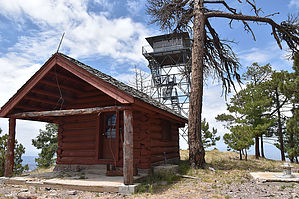
Trail to a Lookout by markthurman53   CREST TRAIL OVERVIEW CREST TRAIL OVERVIEWThe Crest Trails north end is along the Barfoot Park Road and continues southward to Chiricahua Peak, Sentinel Peak, and Monte Vista Peak. This trail is 14.2 miles long and divided into three sections, each traversing a ridge or crest. From Chiricahua Peak, there are three main ridges; to the north, a ridge running to Buena Vista Peak, to the southwest, a ridge running to Monte Vista Peak, and to the southeast, a ridge running to Sentinel Peak. Each of the ridges divides the trail into three sections and two side trails. THREE MAIN ⅄ LEG SECTIONS
6.2 miles: on the north side of Chiricahua Peak Crest Trail #270B - Jct Sdl to Monte Vista Pk 3 miles: Along the west side of Chiricahua Peak Crest Trail #270C - Jct Sdl to Sentinel Peak 5 miles: Along the east side of Chiricahua Peak TWO SHORT OPTIONS Crest Trail #270A - Jct Sdl to Aspen Sdl 0.9 miles: Jct Saddle > Chiricahua Pk > Aspen Sdl on the SE side of Chiricahua Pk Crest Trail #270D - Chiricahua Bypass 1.2 miles: Aspen Sdl to Chiricahua Sdl along the south side of Chiricahua Pk Access to the Crest Trail at various points can be done from Rustler Park to the north, Turkey Creek to the west, Cave Creek to the east, and Rucker Canyon to the South. Only the Rustler Park access is direct; the rest require 5 to 10-mile connecter trails with 3 to 4000 feet of elevation change. These Trails are all at around 9000 feet through heavily wooded areas, and some areas burned pretty severely over the last 20 years. The forest is in different stages of recovery. Weather can change suddenly at this elevation, and if on the trail, be prepared for whatever it can throw at you; there is no quick exit from this trail. CREST TRAIL #270 – JCT SDL TO MONTE VISTA PEAK Description The east trailhead for the Crest Trail #270B starts at Junction Saddle on the north side of Chiricahua Peak. Junction Saddle is the endpoint for the Crest Trail #270 and the northern start point for the Crest Trail #270C to Sentinel Peak. Junction Saddle, along with the north side of Chiricahua Peak, was devastated by the Horseshoe 2 Fire in 2011 and is now recovering with a thick stand of young Aspen trees. Some of the larger old burnt trees are still standing at the saddle; the rest are fodder on the ground. The Crest Trail #270B heads out from the saddle in a southwest direction skirting around the west side of Chiricahua Peak. There are nice views to the west from this section of the trail, looking down Mormon Canyon and all of Turkey Creek. A portion of this trail along the west side of Chiricahua Peak is through aspen groves that came up after the 2011 fire, while other portions are through an old-growth forest untouched by the fire. The trail heads downhill for 0.8 miles to Chiricahua Saddle. Just before getting to the saddle the Mormon Ridge Trail #269 comes in from below. This junction is signed. At the saddle, the Crest Trail #270D comes in from the east. This junction is signed, but it is in pretty ratty shape, looks like a bear took a bite out of the left side of the sign. From Chiricahua Saddle, the trail continues its downhill trend to a rocky saddle at 1.3 miles and 500 feet lower in elevation from the trail start. All along this section of trail from Chiricahua Saddle are great views over Rucker Canyon to the south and east, the ridge that runs from Chiricahua Peak to Sentinel Peak. Paint rock is the interesting outcrop straight ahead. This section of trail all the way to Raspberry Ridge Trail #228 is fairly treeless. The upside is that there is nothing to obscure the views. From the rocky saddle, the trail begins climbing toward Paint Rock which is 0.3 miles away. This is an interesting section of the crest trail. The Crest Trail is, as mathematicians would say, a fairly well-behaved function, climbing gradually over short rounded peaks or traversing around them, doing nothing abruptly. Here the trail heads straight up through a rocky crag of Paint Rock, zig-zagging its way through, an abrupt change from what the trail has been doing. In a short 0.1 miles, the trail crests out and is back to normal, leveling out for the rest of the trail. From Paint Rock, the views back to the north of Chiricahua peak are worth stopping and checking out. At 2.2 miles in is the signed Raspberry Ridge Trail #228 that comes up from Rucker canyon. The Crest Trail continues now in a westerly direction along a reasonably level forested trail until the last 0.1 miles, where it climbs 100 feet to the signed junction with the Turtle Mountain Trail #219 and a short Spur Trail to the Top of Monte Vista Peak. The Crest Trail #270B ends here. The signs at this junction are in pretty bad shape; the only readable one is the one that points out the Crest Trail and Chiricahua Peak. There is a lookout on Monte Vista Peak with fantastic views in 360 degrees and well worth the 0.2-mile trek up. Crest Trail 270B and the same with 270C is the first time Rucker Canyon comes into view. Even on Chiricahua Peak, the views of Rucker Canyon are poor because of the trees. The 270B Trail, along with the 270 Trail, is in good condition and sees moderate use (moderate means on any given day, there is probably one person on the crest trails). The signage along the trail definitely needs some work, best to have a GPS route. Crest Trail #270B offers many opportunities for loop hikes coming out of Turkey Canyon involving the Mormon Ridge Trail #269, Mormon Canyon Trail #352, Morse Canyon Trail #43 and the Pole Bridge Trail #264. Check out the Official Route and Triplogs. Leave No Trace and +Add a Triplog after your hike to support this local community. One-Way Notice This hike is listed as One-Way. When hiking several trails on a single "hike", log it with a generic name that describes the hike. Then link the trails traveled, check out the example. | ||||||||||||||||||||||||||||||||||||||||||||||||||||||||||||||||||||||||||||||||||||||||||||||||||||||||||||||||||||||||||||||||||||||||||||||||||||||||||||||||||||||||||||||||||||||||||||||||||||||||||||||||


