 Route Editor

| Guide | ♦ | 24 Triplogs | 1 Topic |
details | drive | permit | forecast | 🔥 route |
stats |
photos | triplogs | topic | location |
| 346 | 24 | 1 |
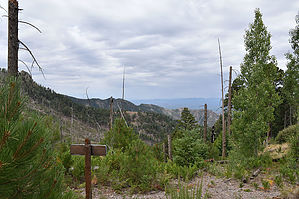
Canyon with a bit of history by markthurman53   CHIRICAHUA MOUNTAINS CHIRICAHUA MOUNTAINSThe Chiricahua Mountains are located in far southeast Arizona on the New Mexico and Mexico border. This mountain is probably the remotest of the over 9000 feet high sky island ranges. The closest towns are Wilcox, 40 miles to the north, and Douglas, about the same to the south. No paved roads enter this range except a short portion on the east side of the range near Portal, Arizona, and there isn’t any short way to get there. One dirt road traverses the range from the west side near the Chiricahua Monument and ends at Portal on the east side. There are two dirt roads on the west side; Turkey Creek and Rucker Canyon allow access to the west side trails. The remoteness makes for great hiking if you prefer solitude. Many of the trails are in poor condition with a few exceptions, ravaged by the Rattlesnake fire in 1994 and the Horseshoe 2 fire of 2011. If you are into route finding, then this is the place to hike. MORMON CANYON TRAIL #352
The Mormon Canyon Trail #352 is one of a handful of trails that you can use to access the Chiricahua Crest Trail #270 from the west. Access to the trail is via the Turkey Creek Road FR41 near the Sycamore Campground. This is a canyon trail, so it follows Mormon Creek until the last bit where the creek ends, then it climbs up to Mormon Saddle, where it ends at a junction with the Mormon Ridge Trail #269. Mormon Canyon is the site of an 1880’s sawmill. The mill was one of a couple built in the Turkey Creek area, this one by Phillip E Morse or possibly Daniel Ross. The mill is no longer there, but there are still artifacts laying around that attest to its existence. This mill may have been mobile (sort of a mobile home for mills) because supposedly, it was moved from this location to Rock Creek in 1886. Mormon Spring is also located near the mill. This trail is through thick forest until the final ascent, where a fire cleared most of the trees and is now in a state of recovery. The Mormon Canyon trail is a continuous 3-mile uphill trail with a slope of about 20%. The vegetation is thick and green, especially in the summer months, and can add to the difficulty of finding the trail. Everyone agrees as to where the lower end of the Mormon Canyon Trail #352 and the Mormon Ridge Trail #269 is, but there is some confusion as to where these trails end. The Forest Service website says the Mormon Ridge trail heads up to Mormon Saddle, then heads north to The Crest Trail #270 just south of Cima Park, and the Mormon Canyon Trail from Mormon Saddle heads south to the Crest Trail #270B near Chiricahua Saddle. The actual signage says differently. The section of the Mormon Ridge trail from Mormon Saddle to Cima Park does not exist anymore, no signs at either end, in fact, no trail in between either. When I hiked that route a few years ago, there was no sign of a trail. It was a bushwhack across rocky taluses and an aspen tree log hop. I couldn’t even find any trace of where the trail leaves the Crest Trail. The current consensus (at least among those that matter) is that the Mormon Canyon Trail ends at Mormon Ridge at the Mormon Ridge Trail and the Mormon Ridge Trail ends near Chiricahua Saddle on the Crest Trail #270B. This agrees with the signage along the trail. At one time, there may have been a trail to Cima Park, but the Horse Shoe 2 fire wiped it out (I’m guessing it was the Horse Shoe 2 Fire, there have been a couple over the last 20 years). Description The Mormon Canyon Trailhead is 0.4 miles south of Sycamore Campground along the Turkey Creek Road FR41. The trail is signed, but the parking is limited. Access can also be from the Sycamore Canyon Campground using a short connector trail that runs along Turkey Creek. The Mormon Canyon Trail starts in Turkey Creek, where it climbs a short ridge that separates Turkey Creek from Mormon Creek. The connector trail that comes from Sycamore Campground connects in before climbing this ridge. The trail heads south then cuts back north as it climbs the ridge; once over the ridge, the trail heads east along Mormon Creek. At ¾ mile from the trailhead, the trail crosses Mormon Creek at the site of Mormon Spring. The actual spring is off on the north side of the creek. A bit to the northwest of the spring is a non-functional cement water trough, dry. Remnants of the old sawmill can still be seen in this area. The trail is pretty faint from the spring to the end of the Mormon Canyon Trail; follow along the creek if in doubt. The creek eventually becomes less obvious as fingers of it head up various small ravines. It is at this point you look for the trail heading up to the ridge. There is a lot of deadfall along this section, and young aspen and pine also try to hide the trail. Portions of this part of the trail are obvious other portions are not. A GPS route is handy to keep you in the vicinity. If all else fails, head up to the saddle, and you will cut the Mormon Ridge Trail. The trail junction on the ridge is signed at least for the Mormon Ridge Trail. Check out the Official Route and Triplogs. Leave No Trace and +Add a Triplog after your hike to support this local community. One-Way Notice This hike is listed as One-Way. When hiking several trails on a single "hike", log it with a generic name that describes the hike. Then link the trails traveled, check out the example. | ||||||||||||||||||||||||||||||||||||||||||||||||||||||||||||||||||||||||||||||||||||||||||||||||||||||||||||||||||||||||||||||||||||||||||||||||||||||||||||||||||||||||||||||||||||||||||||||||||||||||||||||||


