 Route Editor

| Guide | ♦ | 10 Triplogs | 0 Topics |
details | drive | permit | forecast | route |
stats |
photos | triplogs | topics | location |
| 142 | 10 | 0 |
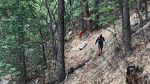
Blue Jays not guaranteed by nonot   Warning WarningThis trail receives little trail maintenance and you may be whacking bushes and climbing over fallen trees. Overview A half loop around Blue Jay Peak in the Pinalenos (in modern English: Mountains of many deer) of eastern Arizona, starting and ending at different portions of the main forest road for Blue Jay Peak (generally Tripp Canyon road).
Generally hiked as part of the Blue Jay Ridge Loop, which uses the forest road to return to your starting point. This other guide provides more in-depth descriptions of the views you will encounter. As you make your way around, the approximate halfway point is Blue Jay Ridge where the trail makes a near U-turn. When you reach this point you will observe unofficial trails leading north that explore further along the ridgeline itself. Feel free to explore but don't get lost! As is typical of Arizona, the northern and eastern flanks of the mountain will have more lush vegetation, whereas the western portion of the ridge will be drier forest. At the eastern end of the trail, the trail merges into a 4x4 road with little fanfare. This section of the mountain is the edge of a large previous fire that burned all of Clark Peak, and there are barely any trees until you follow the road south and past the Clark Peak "trailhead". Water Sources While Turkey Spring near the western end of this trail may have water, it is best planned to bring everything you need with you as the spring doesn't appear to be reliable. The east flank of the mountain does tend to be damp and swampy for a while following rainstorms and may provide a backpacker with a filtering opportunity after a previous day's rain event, but I wouldn't bet my life on it. Camping There are a few camping opportunities near the eastern end of the trail along the 4x4 forest road. Synopsis The trail makes for reasonable hiking in a seldom visited part of the state due to the remoteness of the trailhead, making the trail plus a full loop on the road an easy day of hiking for some (though perhaps not so easy bushwhacking in sections) accompanied by car camping opportunities or else a long day trip for others that would prefer to blitz through the loop with long hours of driving to/from home. This is generally a spring/fall hike - best when it gets a bit too hot for desert hiking, but before or after the worst portions of summer. Check out the Official Route and Triplogs. Leave No Trace and +Add a Triplog after your hike to support this local community. One-Way Notice This hike is listed as One-Way. When hiking several trails on a single "hike", log it with a generic name that describes the hike. Then link the trails traveled, check out the example. | |||||||||||||||||||||||||||||||||||||||||||||||||||||||||||||||||||||||||||||||||||||||||||||||||||||||||||||||||||||||||||||||||||||||||||||||||||||||||||||||||||||||||||||||||


