Corral Canyon Trail #291, AZ | HikeArizona
username
X
password
register
for free!
help
 This is likely a great time to hike this trail!  Check out "Preferred" months below, keep in mind this is an estimate.
  

Corral Canyon Trail #291, AZ

Guide 10 Triplogs  1 Topic
  2.3 of 5 
Fav
Wish
0
details
drive
permit
forecast
route  
stats
photos
triplogs
topic
location
157 10 1
Statistics
tap icons for details
Difficulty 3 of 5
Route Finding 3 of 5
Distance One Way 3.8 miles
Trailhead Elevation 5,071 feet
Elevation Gain 2,072 feet
Accumulated Gain 2,221 feet
Avg Time One Way 2-4 hours
Kokopelli Seeds 11.2
 Interest Seasonal Waterfall & Seasonal Creek
 Backpack Yes
feature photo
Photos Viewed All MineFollowing
Will recalculate on button tap!
11  2023-01-13
East Divide Trail #287 - Galiuro
GrangerGuy
26  2021-03-20
Powers Garden
jacobemerick
41  2015-10-12
Powers Garden
FOTG
30  2015-10-10
Powers Garden
chumley
29  2015-10-09
Powers Garden
BiFrost
20  2014-03-21
Powers Garden Loop and Rhodes Peak
GrottoGirl
Author
author avatar Guides 24
Routes 90
Photos 614
Trips 67 map ( 768 miles )
Age 66 Male Gender
Location Phoenix, AZ
Associated Areas
list map done
Tucson Region
Historical Weather
Trailhead Forecast
Radar Map
Expand Map
Preferred Oct, Nov, Feb, Mar → 7 AM
Seasons   Early Autumn to Late Spring
Sun  6:31am - 6:30pm
Official Route
 
4 Alternative
 
 Water


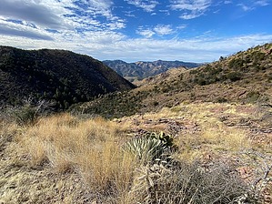
A Challenging Journey to find Hidden Treasures
by GrangerGuy

 Likely In-Season!
Overview
This trail connects the East Divide Trail #287 with the Powers Garden Trail #96. Sections of the trail are difficult to find due to tall grass and deadfall. You won’t see a lot of people on this trail. The trail is described from bottom to top.


Hike
At the bottom, the trail is good. It is marked by occasional cairns and features good tread and not a lot of brush. Someone has clipped a few of the more offensive bits of brush, but it could do with a lot more maintenance.

At around ~1.3 miles from Rattlesnake Creek, the trail becomes pretty vague. For the next half mile or so, just follow the creek, until you encounter a couple of large cairns directing you up the hill on the north side of the creek. If you get as far as Corral Spring, you must backtrack to find the switchbacks up the grassy north side of the canyon, which take you around a redoubtable waterfall.


The switchbacks are hard to find in the grass, but there are regular cairns that appear, letting you know you are on the right track. If you load the GPS tracks from previous HAZers, you can follow those. Eventually, the trail returns to the stream just above the waterfall. The best path onward seems to be in the creek, following the south fork where it splits. There is quite a bit of deadfall to work around.

After a short section a ways up on the south canyon wall, the trail crosses the canyon and begins another aggressive set of switchbacks up the grassy north side of the canyon. The trail is hard to spot, but again, cairns will appear confirming you are on the right path. Just before the top, the trail makes a U-turn around the end of a ridge. Near here is a nice outcrop with good views to Mt Lemmon and Wrightson. From there, it is an easy ½ mile to the intersection at a pass with the East Divide Trail, which is tangled in deadfall.

Check out the Official Route and Triplogs.

Leave No Trace and +Add a Triplog after your hike to support this local community.

2023-02-06 GrangerGuy

    One-Way Notice
    This hike is listed as One-Way.

    When hiking several trails on a single "hike", log it with a generic name that describes the hike. Then link the trails traveled, check out the example.
    WARNING! Hiking and outdoor related sports can be dangerous. Be responsible and prepare for the trip. Study the area you are entering and plan accordingly. Dress for the current and unexpected weather changes. Take plenty of water. Never go alone. Make an itinerary with your plan(s), route(s), destination(s) and expected return time. Give your itinerary to trusted family and/or friends.

     Permit $$
    None

    Coronado Forest
    MVUMs are rarely necessary to review unless mentioned in the description or directions
    Coronado Motor Vehicle Use Maps (MVUMs)


     Directions
    or
    or
     Road
    Connector trail - Not Applicable

    To hike
    From US 70 North of Pima, take Klondyke Road to the Klondyke Bonita Road at a T-intersection. Turn south approximately 4.6 miles to FR #253 and turn right. Follow #253 about 7.3 miles to the Deer Creek Trailhead. From here, hike south on the East Divide Trail for about 3.7 miles, climbing 2200’ to the intersection with Corral Canyon Trail.

    To get to the bottom of the trail, go to Powers Garden, then hike south 1.5 miles on the Powers Garden Trail to the intersection.
    page created by joebartels on Feb 06 2023 6:09 am
    helpcorrectionissue

    end of page marker