Route Editor

| Guide | ♦ | 55 Triplogs | 0 Topics |
details | drive | permit | forecast | 🔥 route |
stats |
photos | triplogs | topics | location |
| 499 | 55 | 0 |
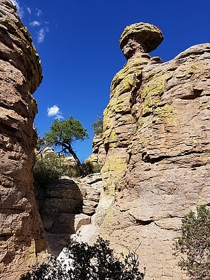
unusual rhyolite aorta by markthurman53   CHIRICAHUA NATIONAL MONUMENT CHIRICAHUA NATIONAL MONUMENTChiricahua National Monument is on the north side of the Chiricahua Mountains in the Southeast corner of Arizona. About as far southeast as you can go in Arizona without being in New Mexico or Mexico. This is almost a fairy tale land of Rock spires, pinnacles, balanced rocks, and hoodoos where the laws of gravity don’t seem to apply. Although the park road traverses the park, to fully enjoy this park requires getting out of the car and hiking some of the 17 miles of trails. All the trails in the park are in excellent condition and well signed. This 12000-acre park was established on April 18, 1924, to preserve the park's natural wonders of weathered volcanic tuff. In 1934 during the great depression, the CCC built the park buildings, many of which still exist today. The many park trails throughout the park today were also constructed by the CCC. Before the monument's 1880s existence, the area was settled by ranchers and, prior to that, the Apaches. The monument has displays on the history, plants, and animals of this unique environment.
If you don’t mind the 2-hour drive from Tucson, Chiricahua Monument is a great place to visit and hike the scenic packed trails. This is relatively remote, so usually not crowded. The four or five times I have been there less than 50 visitors, and at least two of the times less than four cars in the park, and one of them was a park ranger (During the COVID thing). HEART OF ROCKS LOOP Overview The Heart of Rocks Trail, along with the Echo Canyon Trail, are probably the two must-do trails in the park. There is more to see all along these trails than any other trail. This is a trail where you have to just let your imagination go. The CCC did a great job winding this 0.8-mile loop trail through as many nooks and crannies, hoodoos, pinnacles, balanced rocks, and otherwise odd-looking formations as they could. Signs point out the more obvious ones; your imagination will fill in the rest. The trail is well marked because getting lost amongst the rocks could definitely be a problem. This trail is best done by doing a loop hike with the Mushroom Rock, Big Balanced Rock, and Sarah Deming Trail. How much larger a loop you want to do depends on how far you want to walk. Check out the Official Route and Triplogs. Leave No Trace and +Add a Triplog after your hike to support this local community. | |||||||||||||||||||||||||||||||||||||||||||||||||||||||||||||||||||||||||||||||||||||||||||||||||||||||||||||||||||||||||||||||||||||||||||||||||||||||||||||||||||||||||||||||||||||||||||||||