 Route Editor

| Guide | ♦ | 35 Triplogs | 0 Topics |
details | drive | permit | forecast | 🔥 route |
stats |
photos | triplogs | topics | location |
| 370 | 35 | 0 |
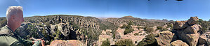
Maybe not Inspirational but great views. by markthurman53   CHIRICAHUA NATIONAL MONUMENT CHIRICAHUA NATIONAL MONUMENTChiricahua National Monument is on the north side of the Chiricahua Mountains in the Southeast corner of Arizona. About as far southeast as you can go in Arizona without being in New Mexico or Mexico. This is almost a fairy tale land of Rock spires, pinnacles, balanced rocks, and hoodoos where the laws of gravity don’t seem to apply. Although the park road traverses the park, to fully enjoy this park requires getting out of the car and hiking some of the 17 miles of trails. All the trails in the park are in excellent condition and well signed. This 12000-acre park was established on April 18, 1924, to preserve the park's natural wonders of weathered volcanic tuff. In 1934 during the great depression, the CCC built the park buildings, many of which still exist today. The many park trails throughout the park today were also constructed by the CCC. Before the monument's 1880s existence, the area was settled by ranchers and, prior to that, the Apaches. The monument has displays on the history, plants, and animals of this unique environment.
If you don’t mind the 2-hour drive from Tucson, Chiricahua Monument is a great place to visit and hike the scenic packed trails. This is relatively remote, so usually not crowded. The four or five times I have been there less than 50 visitors, and at least two of the times less than four cars in the park, and one of them was a park ranger (During the COVID thing). INSPIRATION POINT TRAIL Overview Inspiration Point Trail is a short 0.5-mile trail that leads to, you guessed it, Inspiration Point. If you are on the Big Balanced Rock Trail it is a worthwhile 1 mile round trip to Inspiration Point. This is a fairly level walk all the way to the point. From the point, there are great views over pretty much all of Chiricahua National Monument and areas west. Hunt Canyon is to the east and Totem Canyon to the west. From up here, it is easy to understand how Totem Canyon got its name. The tall columnar pillars lined up side by side of Totem Canyon almost look like Roman soldiers marching in formation. From the point, Rhyolite Canyon is directly below along with the junction of the Ed Riggs Trail, Hailstone Trail and the Mushroom Rock Trail. Check out the Official Route and Triplogs. Leave No Trace and +Add a Triplog after your hike to support this local community. One-Way Notice This hike is listed as One-Way. When hiking several trails on a single "hike", log it with a generic name that describes the hike. Then link the trails traveled, check out the example. | |||||||||||||||||||||||||||||||||||||||||||||||||||||||||||||||||||||||||||||||||||||||||||||||||||||||||||||||||||||||||||||||||||||||||||||||||||||||||||||||||||||||||||||||||||||||||||||||||||||||||


