Route Editor

| Guide | ♦ | 26 Triplogs | 1 Topic |
details | drive | no permit | forecast | 🔥 route |
stats |
photos | triplogs | topic | location |
| 539 | 26 | 1 |
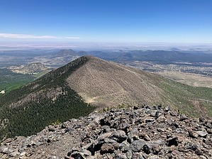
Scorched Earth by John10s  Overview OverviewAt 11,464', Doyle Peak is the fourth-highest of the San Francisco Peaks and the sixth-highest named point in Arizona. Located south of Inner Basin, the peak provides beautiful views of the basin and surrounding peaks, though much of the mountain, including the peak itself, was badly damaged in the 2022 Pipeline Fire. The route detailed here starts from Schultz Trailhead on the south side of the mountain and follows Weatherford Trail up to Fremont Saddle, then takes a short, steep off-trail approach up the west side of the peak. There are several alternative route options to summit Doyle: the Inner Basin to Doyle Peak guide describes an approach from the north side starting from Inner Basin, and a combined guide for Fremont and Doyle Peaks references an approach from the west starting up Humphreys Summit Trail #151 from Snowbowl.
Schultz Trailhead is located just north of Schultz Tank and provides bathroom facilities and a spacious dirt parking lot. From the parking area, cross to the north side of Schultz Pass Road and start hiking north on Weatherford Trail #102. The earliest stretch of Weatherford leaving the trailhead is the only part of the route that isn't directly in the Pipeline burn scar. The portion of Weatherford Trail between Fremont Saddle and Schultz Trailhead, along with Schultz Pass Road, was closed after the fire and reopened in August 2024. The trail steadily gains elevation, passing through areas with varying degrees of fire damage in the early miles. As you climb higher above Weatherford Canyon to the east, large flood channels are visible down below, and a little over two miles in, the trail was rerouted and crosses a major washout caused by flooding after the Pipeline Fire. There are still occasional pockets of undamaged trees along the trail until you're about three miles in. Beyond that point, Weatherford maintains a steady uphill grade as it climbs through a series of long switchbacks. The scenery and tread remain much the same up to the saddle, with lots of sun exposure as you pass through thoroughly charred forest. The trail is easy to follow but often rocky, as runoff has washed away much of the dirt, and you'll cross multiple smaller washouts where maintenance crews have reinforced and reconstructed the trail. Around the seven-mile mark, you'll reach Fremont Saddle at a little over 10,800' in elevation. (Note: topo maps label this as Fremont Saddle, with the saddle on the west side of Fremont Peak--farther away from Doyle Peak--labeled as Doyle Saddle. This seemingly transposed labeling has been a topic of previous discussion on HAZ and is referenced in the History section of the Schultz Peak guide. The HAZ labels for these two saddles have the locations set opposite the topo map names.) From the saddle, Doyle Peak is less than a half mile away, with ~600' of elevation left to gain. Viewed from below, the ascent appears to be a steep but straightforward hike, but fire damage has made the final approach to the summit more precarious. The hillside is covered with deadfall, loose rock and stumps, and generally poor footing, so proceed carefully up to the summit. From the top, the other San Francisco Peaks are on full display, with Fremont, Agassiz, Humphreys, Abineau, and Rees circling Inner Basin from west to east. The northern edge of the Pipeline burn scar is also visible, with Fremont and Doyle both bisected along their ridgelines with green trees on the north faces and charred stumps on the south faces. The sparse remnants of an old cabin remain near the peak, though the fire left only rock and metal behind. The cabin had fallen into disrepair but was rebuilt in 2015-16 by a former inmate named Craig H. Holte before being destroyed in the Pipeline Fire. Holte's journal entries, captured in this photoset, chronicled his reconstruction efforts. (Side note: a Google search on his name turns up some interesting stories.) To return to Schulz Trailhead, you can follow the same route back down to Fremont Saddle and Weatherford Trail or consider looping back via an off-trail route to Schultz Peak or add a trip up Fremont Peak to the day's adventure. Triplogs for this guide, as well as the two other Doyle guides linked in the Overview section above, provide many different route options if you'd prefer to avoid a simple out-and-back hike. Check out the Official Route and Triplogs. Leave No Trace and +Add a Triplog after your hike to support this local community. | ||||||||||||||||||||||||||||||||||||||||||||||||||||||||||||||||||||||||||||||||||||||||||||||||||||||||||||||||||||||||||||||||||||||||||||||||||||||||||||||||||||||||||||||||||||||||||||||||||||||||||||