 Route Editor

| Guide | ♦ | 46 Triplogs | 0 Topics |
details | drive | permit | forecast | route |
stats |
photos | triplogs | topics | location |
| 369 | 46 | 0 |
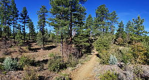
Ancient Pine Secret by joebartels   Overview OverviewHomestead Trail #305 connects the Ranch Trail #62 trailhead with the Smith Ravine #297 trailhead. It offers access to several areas within the Lynx Lake Recreation area. Hike Starting on the north end at the Ranch Trailhead, Homestead Trail #305 begins left/south of the road split entering the parking areas. A slender #305 sign is to the right of the large information signage. The trail is well-signed and the tread is excellent from end to end.
Slender Ponderosa Pines are plentiful. Deciduous Gambel Oaks fill between the pines in several stretches of trail. There is probably one week of very nice Autumn foliage. Evergreen Emory Oak and Arizona White Oaks are forgettable to most but add nice yellow accents for several weeks in the late April to June timeframe. The trail weaves through and crosses 4 roads in Hilltop Campgrounds. Following the Official Route helps navigate the southernmost crossing at 4.3 miles. It follows the road for maybe 50 feet. Alternatives • We have used Homestead Trail #305 in several 20 plus mile all-day loop hikes. • A very nice short loop around would be around Lynx Lake or a 7.9-mile lasso loop from Ranch TH, both using Lynx Recreation Trail #311. • 5 miles roundtrip from the north to a rest bench would be a nice short hike. Camping Hilltop Campgrounds. Dispersed camping is permitted in the Prescott National Forest. However, this trail crosses day-use areas. Camping is only permitted in designated campsites in day-use areas. If unsure, scratch camping the three miles 2 through 5 of the Official Route. Synopsis Roughly averages an 0.1 mi buffer aside Walker Rd. Minus crossing Walker Road once, Walker is obscured by pines galore. Mountain bikers are the primary recreationist. I passed under a dozen bikers on a full-length out-n-back on a Saturday in May. The rule of thumb is bikers yield to hikers. Mountain bikers have been friendlier and saner than hikers in my experiences. Stay aware, step aside and the friendly vibes keep rolling. Attention-dwelling and elite hikers will avoid this trail. It lacks iconic distant mountain views. Pines provide shade from early to late morning and late afternoon. For a less civilized feeling in serious pines consider a short out-n-back from the southern end starting at Smith Ravine Trailhead. Check out the Official Route and Triplogs. Leave No Trace and +Add a Triplog after your hike to support this local community. One-Way Notice This hike is listed as One-Way. When hiking several trails on a single "hike", log it with a generic name that describes the hike. Then link the trails traveled, check out the example. | |||||||||||||||||||||||||||||||||||||||||||||||||||||||||||||||||||||||||||||||||||||||||||||||||||||||||||||||||||||||||||||||||||||||||||||||||||||||||||||||||||||||||||||||||||||


