Route Editor

| Guide | ♦ | 22 Triplogs | 0 Topics |
details | drive | permit | forecast | 🔥 route |
stats |
photos | triplogs | topics | location |
| 140 | 22 | 0 |
Mount Lemmon's Other Loop by Jim  It seems that Mount Lemmon has a loop that is already written and popular: the one that ascends trail #12, Lemmon Rock Lookout Trail. However, that ascends what is, in season, a remarkably hot, sunny slope and something you may not want to do for your final ascent. Perhaps you want a slightly longer hike, or perhaps you want some more expansive views, too. Well, in the effort to produce a ready-made loop with data for the hiker that doesn't have a GPS, the Mount Lemmon Loop is born. It seems that Mount Lemmon has a loop that is already written and popular: the one that ascends trail #12, Lemmon Rock Lookout Trail. However, that ascends what is, in season, a remarkably hot, sunny slope and something you may not want to do for your final ascent. Perhaps you want a slightly longer hike, or perhaps you want some more expansive views, too. Well, in the effort to produce a ready-made loop with data for the hiker that doesn't have a GPS, the Mount Lemmon Loop is born.Overview This loop hike incorporates 3 trails and a bit of road. The trails used are the Mount Lemmon Trail #5, the Wilderness of Rocks Trail #44 ( WOR ), and the Aspen Trail #93. The road is at the very top of the Catalina Highway. The stats reflect a side excursion to the Lemmon Rock Lookout. If you want the shorter loop which ascends Lemmon Rock Trail #12, please use this description that loop.
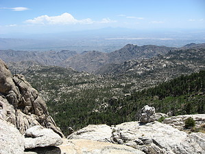
Start from the trailhead, hike up to the gate at the observatory, and wave at the summit(or journey cross country to the summit using the Mount Lemmon 9157' description). From there, descend the road to the Mount Lemmon Trail #5 and hike west on #5 towards the Lemmon Rock Lookout. As you probably will want to, hike the brief side excursion out to the lookout post and enjoy the view. It may be locked in fire season, but you can still enjoy the view from near and around it. Head back to trail #5 and continue to hike down past the Sutherland Trail junction. Start down the switchbacks and curves that lose elevation and drop on to seasonally hot and probably always sunny west-facing slopes with abundant views west and northwest. It can be hot here in early summer, despite the elevation, so carry plenty of water in warmer months. Once you reach the Wilderness of Rocks Trail #44 junction, take a left and hike across the locally famous Wilderness of Rocks. I regret to inform you that the first half of this trail is low, sunny, and maybe hot. It goes fast, at least. In all but the driest times, water is usually found in Lemmon Creek, but even if not, the creek crossing at the halfway point makes a nice resting spot, as do the groves of mature large trees. Birds are abundant here in spring. Pass the Lemmon Rock Lookout Trail #12, or if you prefer, ascend trail #12 to Lemmon Rock Lookout and use that loop hike description for your hike. Otherwise, once past the halfway point and the #12 junction, the open nature of the trail gives way to a more closed canopy and larger trees growing along the creek. Soon you will encounter the junction with several other trails, including the Aspen Trail #93. Here is where you start your final push up to Radio Ridge and more scenic views. I like doing this in the evening, as lights start to show up, and the lighting on the mountain slopes and in the valleys is lovely. It is usually getting cooler, too, which helps a lot for the hike up. The upper Aspen Trail may have been severely burned in the Aspen Fire of 2003, but it really opened the views up a lot, and the forest is regenerating well up here. Lots of widely spaced pines and wildflowers make for a pleasant hike and compliment the views. Once at the top of the ridge and on the road, proceed west to the paved road and onto the parking area. If you don't like the towers, look beyond them at the views, making this one of the best places in the state for distance viewing. If you time it like I prefer to do, enjoy the lights of Tucson some 6,500 feet below this 9,000-foot high ridge. In my opinion, this and the Aspen-Marshall Superloop using Radio Ridge are about the best the top of the mountain has to offer in diversity and views. Gate Policy: If a gate is closed upon arrival, leave it closed after you go through. If it is open, leave it open. Leaving a closed gate open may put cattle in danger. Closing an open gate may cut them off from water. Please be respectful, leave gates as found. The exception is signage on the gate directing you otherwise. Check out the Official Route and Triplogs. Leave No Trace and +Add a Triplog after your hike to support this local community. | ||||||||||||||||||||||||||||||||||||||||||||||||||||||||||||||||||||||||||||||||||||||||||||||||||||||||||||||||||||||||||||||||||||||||||||||||||||||||||||||||||||||||||||||||||||||||||||||||||||||||||||||||||||||||