 Route Editor

| Guide | ♦ | 119 Triplogs | 0 Topics |
details | drive | no permit | forecast | route |
stats |
photos | triplogs | topics | location |
| 1.3k | 119 | 0 |
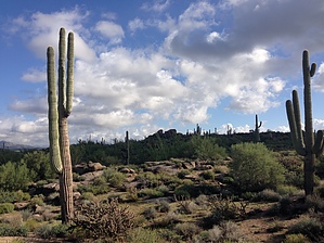
McDowell horizon sampler by Crzy4AZ  2018 Note 2018 NoteThe 2014 guide below is for the original 1.1 mile Latigo Trail. Utilize the new Official Route. This short, easy trail offers a sample platter of classic Sonoran desert terrain combined with expansive views in every direction of the McDowell mountains. Hikers, mountain bikers, equestrians, and trail runners will be drawn to the wide, firmly packed trail with gentle slopes and meandering turns.
Access to Latigo can be found in southeastern corner of the Equestrian parking lot or from the amphitheater heading towards the Jane Rau Nature trail – bear right at this sign and go 0.2 miles to start of Latigo. From trail marker LG1 at the start of Latigo Trail, you head east up and down gentle granite slopes past saguaro, cholla, palo verde, and yucca. I felt like an owl with my head rotating around in all directions to check out the little mountains that pop in and out of view as the trail progresses: Brown & Cone Mountains, Cholla & Granite Mountains, Pinnacle Peak, Tom’s Thumb along the McDowell ridgeline, and Fraesfield Mountain. Some of the higher points of the trail are an ideal location for sunrise and sunset photos. You intersect with 114th Street trail at 0.5 miles and the Latigo trail ends another 0.5 miles later at the junction with 118th Street trail. These two intersecting trails lead south to neighborhood access (no parking access). 118th Street trail continues north to join with Powerline Road trail which takes you either: (1) east to Cholla Mountain Loop and Granite Mountain Loop or (2) west back to Brown’s Ranch Road Trail. Or to experience the Fraesfield Mountain loops, take 118th Street trail south to Dixileta Trail connector.
Check out the Official Route and Triplogs. Leave No Trace and +Add a Triplog after your hike to support this local community. One-Way Notice This hike is listed as One-Way. When hiking several trails on a single "hike", log it with a generic name that describes the hike. Then link the trails traveled, check out the example. | |||||||||||||||||||||||||||||||||||||||||||||||||||||||||||||||||||||||||||||||||||||||||||||||||||||||||||||||||||||||||||||||||||||||||||||||||||||||||||||||||||||||||||||||||||||||||


