consistently changing views end-to-end by joebartels
Quartz Mine Trail begins immediately behind the covered picnic table on the south side of the main parking lot. With an immediate left, the trail gently rises 30 ft to a low saddle. Watson Overlook is the junction at the saddle.
Tread is consistently three feet wide, with gentle grades. Soon, you see the entrance hut, a reassurance of where you are on planet earth. Just over a half-mile in, you pass the Parking Lot Connector Trail junction. The next half-mile takes you east. The notable views are the end view of the Sierra Estrella Range to the southeast, and Javelina Summit is east-northeast aka Beacon 2212 on topo.
Heading north, Javelina Summit looks larger than life, semi-independent at this southern end of the White Tank Mountains. Rippled ravines leading up to it are covered in flora that must have been what the Phoenix Preserves resembled before the human invasion. Skyline Crest Trail junction is on a right turn at 1.5 miles, stay right. Tortuga Trail junction comes quick at 1.6 miles, continue left.
The final mile north is a relaxed stroll up the side of four mini-cattywampus ridges to Lost Creek Trail. One or two paloverdes canopying over the trail offer nice photo opportunities.
Synopsis
Quartz Mine Trail hits a lot of positives with a near-effortless tread through continuously changing views.
When hiking several trails on a single "hike", log it with a generic name that describes the hike. Then link the trails traveled, check out the example.
WARNING! Hiking and outdoor related sports can be dangerous. Be responsible and prepare for the trip. Study the area you are entering and plan accordingly. Dress for the current and unexpected weather changes. Take plenty of water. Never go alone. Make an itinerary with your plan(s), route(s), destination(s) and expected return time. Give your itinerary to trusted family and/or friends.
Permit $$
no fees or permits reported
if incorrect tell us about it
Directions
Road
Paved - Car Okay
To Skyline Park Trailhead From Phoenix, take I-10 west to Watson Rd. Exit, and go north on Watson. Take Watson north approx 2 miles into the park.
The Entrance Lot is immediately after the gate where Watson turns 90 degrees west(left)
About 10-12 cars slot park on dirt just off the edge of the road.
- Parking Lot Connector Trail
- mid access to Quartz Trail
The developed Discovery Point Lot is 0.3 miles further in on Watson.
I'm not 100% sure on that name, needs verified. It's an obvious half moon oval.
- mid access to Parking Lot Connector Trail
The Main Lot is another 0.3 miles at the end of the road.
- all else, the majority
Park entry is FREE! Trails open sunrise to sunset. Gates close at 10 p.m.
From PHX (I-10 & AZ-51) 36 min (34.9 miles) From TUC (Jct 1-10 & Grant) 2 h 3 min (142 miles) From FLG (Jct I-17 & I-40) 2 h 22 min (159 miles)
 Route Editor

 Quartz Mine Trail begins immediately behind the covered picnic table on the south side of the main parking lot. With an immediate left, the trail gently rises 30 ft to a low saddle. Watson Overlook is the junction at the saddle.
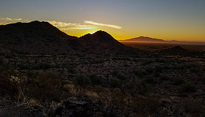


