Route Editor

| Guide | ♦ | 4 Triplogs | 0 Topics |
details | drive | permit | forecast | route |
stats |
photos | triplogs | topics | location |
| 37 | 4 | 0 |
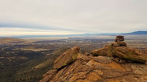
Prescott Valley Overlook by Peter_Medal   Prescott Valley's Stoneridge Golf Community is rightfully named from this unnamed ridgeline and peak of the northeasternmost range of the Bradshaw Mountains and the Prescott National Forest. The high point of this range is Mount Elliott. Other notables include Bear Down Mountain and Sun Devil Peak. The range is bounded by Diamond Valley and Prescott Valley to the north; Dewey-Humboldt and Highway 69 to the east; Mayer to the southeast; Breezy Pines & Poland Road to the south; and the Walker Valley/Lynx Lake to the west. Charcoal Gulch Trail runs much of the range from north to south. Its northern trailhead, the Green Gulch Trailhead is the eastern port of entry for what the Prescott National Forest calls the Blue Range. Stoneridge Peak's nearest neighbor, Sun Devil Peak is one mile south. Officially, "Stoneridge Peak" is UN 6542' from USGS Topographic Maps. Its prominence is easily seen from just about anywhere looking south from the Town of Prescott Valley. It's a pointy, pyramid-type peak. Its east and west side view displays its glorious wavy ridgeline with 4 prominent bumps. Prescott Valley's Stoneridge Golf Community is rightfully named from this unnamed ridgeline and peak of the northeasternmost range of the Bradshaw Mountains and the Prescott National Forest. The high point of this range is Mount Elliott. Other notables include Bear Down Mountain and Sun Devil Peak. The range is bounded by Diamond Valley and Prescott Valley to the north; Dewey-Humboldt and Highway 69 to the east; Mayer to the southeast; Breezy Pines & Poland Road to the south; and the Walker Valley/Lynx Lake to the west. Charcoal Gulch Trail runs much of the range from north to south. Its northern trailhead, the Green Gulch Trailhead is the eastern port of entry for what the Prescott National Forest calls the Blue Range. Stoneridge Peak's nearest neighbor, Sun Devil Peak is one mile south. Officially, "Stoneridge Peak" is UN 6542' from USGS Topographic Maps. Its prominence is easily seen from just about anywhere looking south from the Town of Prescott Valley. It's a pointy, pyramid-type peak. Its east and west side view displays its glorious wavy ridgeline with 4 prominent bumps.Although National Forest maps show access to this mountain could be entered via Prospectors Trail #42 this entry is no longer viable for public access (private roads and gates with "no trespassing"). The ideal trailhead for Stoneridge Peak is from the Salida Gulch Trail #9263 from the east, or, the Green Gulch Trailhead from the east (Dewey/Humboldt). There is no parking fee at the Green Gulch Trailhead. Directions noted for this hike description are for the Green Gulch Trailhead.
Approaching its summit is an easy rock climb with limited exposure. Views from the top are highly rewarding which include: Granite Mountain; Watson Lake; Willow Lake; Diamond Valley; Glassford Hill; Prescott Valley; Stoneridge Golf Community; Sun Devil Peak; Bigelow Peak; Mount Union; Mount Davis; and Spruce Mountain. There is a geocache summit register in the belly of the peak's summit cairn. Vegetation of the area is predominately scrub oak; chaparral; manzanita; NM locusts; prickly pear; and an occasional alligator juniper. Above 6300' are shin daggers. The geology of the area is mainly Precambrian granite. Gate Policy: If a gate is closed upon arrival, leave it closed after you go through. If it is open, leave it open. Leaving a closed gate open may put cattle in danger. Closing an open gate may cut them off from water. Please be respectful, leave gates as found. The exception is signage on the gate directing you otherwise. Check out the Official Route and Triplogs. Leave No Trace and +Add a Triplog after your hike to support this local community. | ||||||||||||||||||||||||||||||||||||||||||||||||||||||||||||||||||||||||||||||||||||||||||||