 Route Editor

| Guide | 0 Triplogs | 0 Topics |
details | drive | permit | forecast | 🔥 route |
stats |
photos | triplogs | topics | location |
| 4 | 0 | 0 |
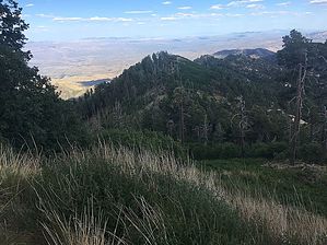
Mt Bigelow's younger sibling by Mike_W   Anyone who's hiked Mt. Bigelow probably noticed this small mountain. Interestingly, the Kellogg Mountain Trail #45 doesn't go to the top of Kellogg Mountain summit. Anyone who's hiked Mt. Bigelow probably noticed this small mountain. Interestingly, the Kellogg Mountain Trail #45 doesn't go to the top of Kellogg Mountain summit.To get there, reach the 3-way junction of the Butterfly Trail #16, Mount Bigelow Trail, and the Kellogg Mountain Trail. Continue Northeast on the Butterfly Trail for about 50 feet. Look to the East, and you will see this peak. It's about a 10 minute easy bushwhack to get to the top. Follow the top of the ridge, and you shouldn't have any problem getting to the top. There are several logs to step over along the way. From the top, there are some great views of Mt Bigelow and the surrounding area. There is a geological marker that appears to be east of the true peak, a few feet lower than the highest point. It's possible to continue eastward, but it gets rather steep and messy.
Warning: In some areas the steepness was more than a 45 degree incline. But "luckily", the brush was so thick that it provided some level of support from not falling or slipping! It ended up taking me about 30 minutes to get down. There may have been a better route, but I didn't find one. All in all, it was an excellent short adventure! Check out the Official Route. Leave No Trace and +Add a Triplog after your hike to support this local community. One-Way Notice This hike is listed as One-Way. When hiking several trails on a single "hike", log it with a generic name that describes the hike. Then link the trails traveled, check out the example. | |||||||||||||||||||||||||||||||||||||||||||||||||||||||||||||||||||||||||||||||||||||||||||||||||||||||||||||


