 Route Editor

| Guide | ♦ | 3 Triplogs | 0 Topics |
details | drive | permit | forecast | 🔥 route |
stats |
photos | triplogs | topics | location |
| 10 | 3 | 0 |
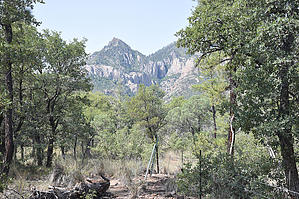
Cave Creek Dams by markthurman53   CHIRICAHUA MOUNTAINS CHIRICAHUA MOUNTAINSThe Chiricahua Mountains are located in far southeast Arizona on the New Mexico and Mexico border. This mountain is probably the remotest of the over 9000 feet high sky island ranges. The closest towns are Wilcox, 40 miles to the north, and Douglas, about the same to the south. No paved roads enter this range except a short portion on the east side of the range near Portal, Arizona, and there isn’t any easy way to get there. One dirt road traverses the range from the west side near the Chiricahua Monument and ends at Portal. The remoteness makes for great hiking if you prefer solitude. With a few exceptions, many of the trails are in poor condition, ravaged by the Rattlesnake fire in 1994 and the Horseshoe 2 fire of 2011. If you are into route finding, then this is the place to hike. SNOWSHED BASIN TRAIL
You will not see a Forest Service reference to this trail or a trail number, I have found no maps that show this trail, but it is there nonetheless. There is a sign along the trail that references it as the Snowshed Basin Trail because it links the Snowshed Trail #246 with the Basin Trail #600. Access to this trail from the east is from the Snowshed Trail, spur trails along the trail from the Chrystal Cave parking area and John Hands Campground, on the west side at the Herb Martyr Trail near the Herb Martyr Campground. This is a relatively flat 2-mile trail and traverses the south side of the Cave Creek Basin. The trail passes through wooded areas of Oak, pine, and juniper. On the west end are some great views up Cave Creek Canyon and Cima Canyon up to the Chiricahua Crest. If you are camped in the area, this makes for great day hikes visiting Herb Martyr and John Hands Falls. Description Access to the trail's east end is 1 mile in along the Snowshed Trail #246. At the signed intersection, the Snowshed trail continues in a northeast-southwest direction, and the Snowshed Basin Trail heads off to the northwest. There are not a lot of views along this section as you are in a Juniper grassland forest. Occasional, a few views look back to the northeast across Cave Canyon of Mount Sceloporus and Silver Peak. About 0.5 miles in is the signed junction with a spur trail leading to the Chrystal Cave parking area along FR42A (Herb Martyr Road). Near this parking area is the only sign I saw that references the Snowshed Basin Trail. This .3 mile spur offers an access point to the Snowshed Basin trail along its eastern side. The trail continues on west from this junction following through pine, oak, and juniper forest. The next 1.5 miles, the trail gradually climbs 350 feet, still making this a relatively flat trail. At 0.9 miles in the John Hands Falls is off to the right along Cave Creek. This is actually a dam in the creek to make a reservoir that has since been filled in with sand, leaving a 10-foot waterfall. This is worth the 0.1 mile side trip to see. This is also another access point to the Snowshed Basin Trail from FR42A (Herb Martyr Road). Along this section of the trail are some good views to the west of Centella Point up on the Chiricahua crest. The trail continues along the south side of Cave Creek for the next mile but set back in the forest a few 100 yards. At 1.8 miles in is Herb Martyr Falls, this is another dam that has been backfilled, creating a 20-foot waterfall. The trail is now about 80 feet above the falls, so access to the falls is not as easy as the John Hands Falls was. Good views of the falls from here, but access to the falls is best done by continuing 0.2 more miles to the Herb Martyr Trail and following that 0.2 miles down to the falls. There are some good views of upper Cave Creek and Cima Creek along the last half mile of the Snowshed Basin Trail. Winn falls is not visible from this trail, but there are some great views of where it is approximately. The only view of the falls is along Greenhouse Trail #248. This trail follows the Cave Creek camping areas, so the wildlife, especially deer, is plentiful and used to human activity, at least when it’s not hunting season. This trail also lends itself to loop hikes involving the Snowshed Trail #246 and the Herb Martyr Trail #247. Check out the Official Route and Triplogs. Leave No Trace and +Add a Triplog after your hike to support this local community. One-Way Notice This hike is listed as One-Way. When hiking several trails on a single "hike", log it with a generic name that describes the hike. Then link the trails traveled, check out the example. | |||||||||||||||||||||||||||||||||||||||||||||||||||||||||||||||||||||||||||||||||||||||||||||||||


