Route Editor

| Guide | ♦ | 2 Triplogs | 0 Topics |
details | drive | permit | forecast | route |
stats |
photos | triplogs | topics | location |
| 42 | 2 | 0 |
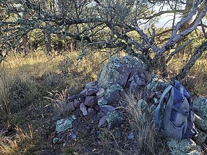
yet another Granite peak by Mike_W  Overview OverviewGranite Peak in the Huachuca Mountains is roughly 2 miles west of Carr Peak and involves a 1/4 mile easy bushwhack following a 5.4-mile hike on the Carr Peak Trail #107 and the Arizona Trail / Crest Trail #103, which are both very well maintained and easy to follow. Hike Park at the Carr Peak trailhead near the Ramsey Vista campground area and start hiking up to Carr Peak via Carr Peak Trail #107. You will reach the Carr Peak junction after 2.6 miles which leads up to Carr Peak. It will be roughly 0.3 miles to summit Carr and another 0.3 to get back down to this junction. In order to get to the base on Granite Peak you will need to continue west and then south on the Carr Peak Trail #107.
Continue west along Crest Trail #103 for roughly 0.5 miles to the west side of Granite Peak. From here it's a short 0.15-mile bushwhack to the summit. On the peak, you'll see a rock pile with a registry. There will also be some nice blue agave plants near the top. To get down you could go back the way you came or you could bushwhack down the east side of Granite mountain. I chose to bushwhack down the east side of Granite mountain back down to Bear Saddle. From there, I picked up Crest Trail #103 and headed back east to Carr Peak Trail #107 and back down to the Carr Peak trailhead where I parked. Check out the Official Route and Triplogs. Leave No Trace and +Add a Triplog after your hike to support this local community. | ||||||||||||||||||||||||||||||||||||||||||||||||||||||||||||||||||||||||||||||||||||||||||||||||