Route Editor

| Guide | ♦ | 2 Triplogs | 0 Topics |
details | drive | permit | forecast | route |
stats |
photos | triplogs | topics | location |
| 35 | 2 | 0 |
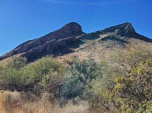
Show me the money! by Mike_W  Warning WarningThis hike is a bushwhack most of the way. There is no trail and I'm sure there are easier ways to ascend than the route that I took, probably from the west/north side of the mountain. If you follow my route, expect to see areas of catclaw bush, prickly pear, ocotillo, some steep cliffs, and razor-sharp rocks in certain areas. The good news is you can hike around most of the thorny stuff if you select your route carefully, and you can go around the steep areas. Overview The Devil's Cashbox consists of a small group of mountains that are near the Whipple Obserevatory on Mt Hopkins road, and are a part of the Santa Rita mountain range. This hike is to the high point of those mountains which is just over 5,000 feet in elevation and toward the southeastern side of this group of mountains.
Start at the intersection of Forest Service 4077 and Mt Hopkins road. Take FS 4077 north for about 0.5 miles. Near the start of the trail, if you look up to the west, you will see 2 high points. Both high points have rocky cliffs that will face you. The high point is the peak that is further away from FS 4077. After about 0.5 miles of hiking, you will turn left off the road and start your bushwhack. Climb Southwest up the slope going toward the rocky cliff in front of you. You'll see several cattle trails around the bottom 2/3 of this slope. Some of these cattle trails can be used to get higher up this slope, avoiding the dense patches of catclaw bush. I had to step on/over some of those to get past them easier. When you get close to the cliff, start heading west. After roughly 200 feet you will see a safe way to climb around the rocky cliffs which is basically an 8 feet rocky area with good places to step. From this point, you will see a saddle looking up to your left. Between the saddle and the peak, there are some more rocky cliffs. I decided to skip going to the saddle and continue to hike south and west to a low point in the rocky cliff. This looked like a place where it would be possible to cross over onto the slope where the peak would be easier accessible. Cross over to the other side, and hike up to the top from here. You'll need to go around some ocotillo and zig-zag a bit to find the best route up. At the top, you will see a registry under a rock pile. As of November 2022, I saw only 1 name per year, since 2019. There are some nice views of the Whipple Observatory to the west. You'll also be to see many high points in the Santa Rita mountain range, including Mt Hopkins, Elephant Head, Little Elephant Head, and a few others. Interestingly, Mt Wrightson is out of sight and behind Mt Hopkins from this point. From the peak, I decided to go down a different way, which was to the south and east. On the way down, I saw some mining holes, some of which appeared to be 10 feet deep with mine tailings in many areas. It would appear that the miners who worked here would have had to hike up and carry any equipment they had. These cliffs were way too steep for vehicles or horses. On my hike down, it was quite steep in some areas and I needed to spider crawl near the very bottom to get down to the canyon below. The canyon was very nice once I got there, open and wide. If I were to hike this peak again someday, I think I would choose to ascend from and descend to the west or north where the slope is not quite as steep. Check out the Official Route and Triplogs. Note This is a moderately difficult hike. Leave No Trace and +Add a Triplog after your hike to support this local community. | ||||||||||||||||||||||||||||||||||||||||||||||||||||||||||||||||||||||||||||||||||||||||||||