Route Editor

| Guide | ♦ | 1 Triplog | 0 Topics |
details | drive | no permit | forecast | route |
stats |
photos | triplog | topics | location |
| 38 | 1 | 0 |
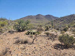
the drive is harder than the hike! by Mike_W  Overview OverviewThe Roskruge Benchmark is a high point in the Roskruge mountains, which is about 7.5 miles North/Northwest of the town of Three Points, and just South of the boundary of the Tohono O'odham Indian Reservation. It's about a 10.5-mile drive down some dirt roads to get to a good starting point. There are several wash crossings and the brush on both sides of the road can be thick and thorny at times. You will need a 4x4 high clearance vehicle and you can't care too much about your paint job, cause your vehicle will get scratched up. From the top of this mountain, you will have some nice views of Kitt Peak and Coyote Mountain to the Southwest, along with some other points of interest in the Roskruge Mountains such as Martina Mountain and Sharp Peak, which are also to the Southwest.
In May 2023, in the wash, near the beginning of the hike, I saw a lot of trash, discarded clothing, backpacks, and other debris that was left by migrants, drug traffickers, etc. All of these items looked pretty recent if I had to guess. Be careful when hiking in these areas and it would be better if you did not hike alone or told people where you planned on hiking. Hike Start by parking off the side of the road in an area where there is a clearing. If you parked where I parked you should see a crested saguaro about 100 feet West of this clearing. Start by hiking through some open desert terrain heading North / Northeast until you reach a road. Continue North at the road until it ends within only a few hundred feet. Continue North / Northeast for another few hundred feet and you should run into a sandy wash. Generally, this wash heads North but does a little winding along the way. You might see some trash, backpacks, and debris left by migrants, drug traffickers, etc. in this area. The trash I found looked pretty recent as of May 2023. Continue until you have hiked a total of roughly 0.5 miles. Then, you will exit the wash on the right side and head Northeast toward the high point. This is really an open country hike up a slope that isn't too steep if you stay on the ridgeline. Try to stay in the middle of the ridgeline and you should be fine. Continue until you reach a high point. From your first high point, which appears to be a false summit, you will see the real summit about 750 feet to the East. You'll need to drop down a bit, then continue East and then Southeast to get to the high point. About 100 feet before reaching the high point, you should see a trinchera, most likely built by the Hohokam Indian tribe many years ago. It's basically a rock wall construction that forms a rough circle about 10 feet in diameter and is used for shelter, hiding, etc. I've also seen some of these on the top of Cerro Prieto (Dark Hill, in English) near Red Rock, AZ. At the peak, you'll see a US survey marker labeled "Roskruge" with dates 1919 and 1935. From the top, you'll have some nice views of the mountains and high points mentioned in the overview. When I was here I noticed several burned cylinders, which I later discovered were most likely flares that were probably left by surveyors. Why this trash wasn't cleaned up is a mystery to me. Continue down the same way you came up to return to where you parked. Check out the Official Route and Triplog. Leave No Trace and +Add a Triplog after your hike to support this local community. | ||||||||||||||||||||||||||||||||||||||||||||||||||||||||||||||||||||||||||||||||||||||||