username
X
password
register
for free!
help
  

Peak 5675 - Tumacacori Mountains, AZ

Guide 1 Triplog  0 Topics
  5 of 5 
Fav
Wish
0
AZ > Tucson > Ruby
details
drive
permit
forecast
route  
stats
photos
triplog
topics
location
71 1 0
Statistics
tap icons for details
Difficulty 3.5 of 5
Route Finding 3 of 5
Distance Round Trip 9 miles
Trailhead Elevation 3,575 feet
Elevation Gain 2,072 feet
Accumulated Gain 2,730 feet
Avg Time Round Trip 7 hours
Kokopelli Seeds 22.65
 Interest Off-Trail Hiking, Seasonal Creek & Peak
 Backpack Possible - Not Popular
unreported if dogs are allowed
editedit > ops > dogs to adjust
feature photo
Photos Viewed All MineFollowing
71  2023-06-11 Mike_W
Author
author avatar Guides 69
Routes 113
Photos 4,811
Trips 277 map ( 1,546 miles )
Age 51 Male Gender
Location Tucson, AZ
Historical Weather
Trailhead Forecast
Radar Map
Expand Map
Preferred Mar, Apr, Oct, Nov → 8 AM
Seasons   Autumn to Spring
Sun  6:07am - 6:33pm
Official Route
 
0 Alternative
 
 Water


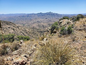
40 ft above Tumac BM. Why doesn't this peak have a friendly name?
by Mike_W

Overview
Peak 5675 is 60 feet lower than the Tumacacori Mountains high point, but worth checking out if you're up on the same ridgeline. Basically, this hike involves walking roughly 2.75 miles up an old steep 4x4 road. Near the high point of the road, you'll need to bushwhack to a saddle which is 1/3 to 1/2 of a mile further up the canyon. From that saddle, it's another 1/2 mile to the peak. There's an unmarked ridgeline trail that will take you part of the way to the peak.


Hike
Start by hiking up the 4x4 road. There are some very steep and rocky sections and I can't imagine what vehicle ever could have driven up this road. Perhaps they just used horses or mules for the mines in this area. Stay on the road for about 2.75 miles until it reaches a high point. The road continues, curving around and heads toward some old mine prospects.

Once at the high point of the road, you should be able to look West and UP and see a saddle. This is your next goal and the most challenging part of your hike. You can either bushwhack up to the saddle or you can climb up the ridgeline that heads just North of it. This whole area has a lot of cat claw weed, shin daggers, etc. You can navigate around the shin daggers but the cat claw weed is all over the place. Wear jeans and you should be able to hike through it carefully without any scratches. Luckily the cat claw weed is nowhere near as thick as the cat claw bush, seen in other areas. The shin dagger has a nice-smelling yellow flower which is only present at certain times but was seen in early June.


Continue to the saddle or any point on the ridgeline North of the saddle. Once on the ridgeline, you will see a trail heading North. Take this trail until you are roughly 1/4 mile North of the saddle. Somewhere in this area, you'll want to get off the trail and curve West, heading up to the top of Peak 5675. The hike from the saddle to the peak is quite easy. Along the way, it is very likely that you will see some unusual rocks, some broken, and some with hollow cavities containing mineral formations on the inside. See my photoset for more info.

At the high point, you'll see a rockpile and a registry inside. The peak has a lot of scrub oak, some prickly pear, yucca, bear grass, etc. There are some shady areas under some of the scrub oak and various bushes. From here, if you look West you'll have some nice views of Baboquivari peak. Looking North along the same ridgeline you may be able to see at least one white observatory tower on Kitt Peak.


On our descent, we stopped about 20 minutes from reaching the 4x4 road to explore a very unique rock area on the South side of the canyon. This area was very shady and it would be possible to camp here. See my photoset for more info.

Once we reached the road, we decided to take the road to the South end, to explore the old mining prospects. We didn't see any mine shafts probably because they were all filled in but did see a lot of mine tailings, an old broken wheelbarrow without a wheel, and a "hidden" place where someone camped up alongside the rocky cliffs. In this area, we saw a lot of thorny trees, which I believe were New Mexico Locust trees. After exploring this area, we walked the old 4x4 road back to where we parked.

Check out the Official Route and Triplog.

Leave No Trace and +Add a Triplog after your hike to support this local community.

2023-06-13 Mike_W
    WARNING! Hiking and outdoor related sports can be dangerous. Be responsible and prepare for the trip. Study the area you are entering and plan accordingly. Dress for the current and unexpected weather changes. Take plenty of water. Never go alone. Make an itinerary with your plan(s), route(s), destination(s) and expected return time. Give your itinerary to trusted family and/or friends.

     Permit $$
    None

    Coronado Forest
    MVUMs are rarely necessary to review unless mentioned in the description or directions
    Coronado Motor Vehicle Use Maps (MVUMs)


     Directions
    or
    or
     Road
    Paved - Car Okay

    To hike
    The trailhead is about one hour south of Tucson and is near Rock Corral Spring.

    From Tucson, take I-19 south to Exit 29 for Tumacacori-Carmen. After exiting, turn right and the road will almost immediately turn to dirt. Travel for 2.2 miles to the "trailhead" which has enough room for 4-5 vehicles to park. After driving 1.6 miles you will come to a junction with FR 4145 and FR 4145A. Take the left fork for FR 4145 and start going down a hill on the way to the TH. A high clearance 4WD vehicle is preferred to make the drive, but if the road is dry a strong SUV should be able to drive to the FR 4145-FR 4145A junction; an SUV should consider parking here, which will add 1.2 miles round-trip to the hike.

    If you enter "Rock Corral Spring" into google maps, you will be able to get to within 400 feet of the parking area. Just continue for 400 feet and you'll come to the parking area. There is a fire ring and a good place to camp at the trailhead.
    page created by Mike_W on Jun 13 2023 1:12 pm
    helpcorrectionissue

    end of page marker