Route Editor

| Guide | ♦ | 5 Triplogs | 0 Topics |
details | drive | no permit | forecast | 🔥 route |
stats |
photos | triplogs | topics | location |
| 95 | 5 | 0 |
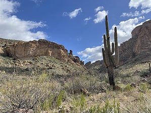
Come for the cave, stay for the summit by John10s  Overview OverviewHerman Mountain has a relatively flat-topped, nondescript peak, much like its taller neighbor to the north, Music Mountain. With relatively flat slopes on several sides, there are a variety of potential routes to reach the high point. The route described here starts from Peralta Trailhead and eventually leaves Red Tanks Trail #107 to follow a drainage on the south side of Herman Mountain up to the top. Hike The majority of this hike follows the route to Herman's Cave; you can read the linked guide for a much more detailed description of the on-trail portion of this route. The short version is as follows: hike east from Peralta Trailhead on Dutchman Trail #104 through Barkley Basin and past the Coffee Flat #108 intersection, staying on #104 to the intersection with Whiskey Spring Trail #238 ~4.5 miles in. Turn east onto #238 as the trail descends and eventually turns north toward Whiskey Spring. Around 6.5 miles in, turn east onto Red Tanks Trail #107, hiking into Upper La Barge Canyon, where the trail crosses the creek bed several times and becomes a little tougher to follow.
Start making your way north up the drainage, but take time to enjoy the views of Picacho Butte and Upper La Barge behind you. Although the terrain isn't too steep, thick brush and catclaw present the biggest challenges. Choose the easiest path, which may alternate between the bottom of the drainage and up on the banks depending on the vegetation. There are some interesting rock formations as you continue north, and the drainage eventually turns to the northeast. Look for a reasonable spot to leave the drainage; the brush is less dense as you proceed up a rocky hillside toward Herman Mesa. As you ascend the hillside, you'll have a good view of the drainage and the formations you've just navigated. Once atop the mesa, the views start to open up to the west. Over the last quarter mile, the slope flattens out a bit as you continue east through low desert vegetation and occasional catclaw to reach the high point at 4,019'. On the western horizon you'll see the Superstition Ridgeline, Miner's Needle, Weaver's Needle, and other popular Superstition landmarks. Picacho Butte and Coffee Flat Mountain are the major features to the south, and looking northeast across Trap Canyon, Music Mountain and Tortilla Mountain are the closest peaks. Approaching the cliff just east of the high point, you can look across Red Tanks Divide toward La Barge Mountain, with Hoolie Bacon Trail #111 down below. When you're ready to start back, you can return via the same route or consider other options for the descent--trip logs include multiple alternate routes up/down Herman Mountain. If you decide to hike out on Red Tanks, Herman's Cave is worth a visit. The approach is steep and loose in places, but the cave is only a short distance off the trail. Check out the Official Route and Triplogs. Leave No Trace and +Add a Triplog after your hike to support this local community. | ||||||||||||||||||||||||||||||||||||||||||||||||||||||||||||||||||||||||||||||||||||||||||||||||||||||||||||||||||||||||||||||||||||||||||||||||||||||||||||||||||||||||||