Bog - Kent Springs Loop, AZ | HikeArizona
username
X
password
register
for free!
help
   🔥

Bog - Kent Springs Loop, AZ

Guide 65 Triplogs  2 Topics
  3.4 of 5 
Fav
Wish
5
details
drive
permit
forecast
🔥
route  
stats
photos
triplogs
topics
location
387 65 2
Statistics
tap icons for details
Difficulty 2.5 of 5
Route Finding 1 of 5
Distance Round Trip 5 miles
Trailhead Elevation 5,100 feet
Elevation Gain 1,600 feet
Avg Time Round Trip 4 hours
Kokopelli Seeds 13
 Backpack Possible & Connecting
feature photo
Photos Viewed All MineFollowing
Will recalculate on button tap!
31  2022-11-13 BubbaJuice
1  2021-12-26 gummo
5  2021-10-29 gummo
2  2021-02-15 gummo
3  2020-11-08 marksy95
5  2020-10-25 marksy95
3  2020-07-18 fricknaley
6  2020-07-12 gummo
Page 1,  2,  3,  4,  5
Author
author avatar Guides 4
Routes 0
Photos 0
Trips 31 map ( 194 miles )
Age 54 Female Gender
Location Apache Junction, AZ
Associated Areas
list map done
Tucson Region
Historical Weather
Trailhead Forecast
Radar Map
Expand Map
Preferred Apr, Sep → 9 AM
Seasons   ALL
Sun  6:46am - 6:24pm
Official Route
 
0 Alternative
 
 Water
Historic Fire Perimeteracres
🔥 2005 Florida Fire23.2k


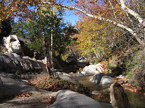
Right Son!
by landsinaz

Bog Springs Trail runs through part of Coronado National Forest and Mount Wrightson Wilderness Area. Like Madera Canyon, it is a prime location for bird watching due to the water. This is truly a great example of 'sky islands.'


This hike starts in the Santa Rita Mountains from the Bog Springs Campground. The trail begins by climbing moderately on lots of loose rocks. The trail is wide and easy to follow as this was once an old road. AT approximately .7 miles in, there is a signed junction where you bear left. On this visit the Manzanita were blooming and absolutely beautiful. At the junction the trail narrows and climbs slowly another .8 miles to Bog Springs. There are views off to your left, but they are dominated by the big, ugly mine near Green Valley. The views get better shortly thereafter.

Bog Springs is a small, man-made, cement rectangle with a slow flow of water. Not terribly exciting, but the huge Cottonwoods and shade make this a pretty spot. From Bog Springs, the trail continues to Kent Spring approximately 1.2 miles further in. This part of the trail gets pretty steep, but it does offer some great views of Mount Wrightson and Madera Canyon. At this point the vegetation is pre-dominantly Chihuahua pines.


Kent Springs is another man made spring, this time round, with a pretty strong flow of cold water. Again, lots of large trees and a streambed running down the hill. There was a small amount of water in the streambed---just enough for it to sound relaxing and peaceful. There are also good views in this area of Kitt Peak and Baboquivari Peak to the east. From here, the trail begins to descend toward Silvester Spring, once again following an old jeep road. This descent is steep. Along part of this descent, you parallel a stream, which makes for a beautiful walk. Keep you eyes open---we startled some Big Horn ewes that were drinking at Silvester Spring. There are some small waterfalls and cascades as well.

The trail is well kept and clearly marked. This area is supposed to be great for birds, even some strays from Mexico like the elegant trogon and the Lucifer's hummingbird. Bird season appears to be April to September and makes this area get busy. We were here on a Friday in late February and had the trail to ourselves. Because of the water, white tailed deer, black bears and coatimundis, as well as the big horns and javelinas frequent the area.

Check out the Official Route and Triplogs.

Leave No Trace and +Add a Triplog after your hike to support this local community.

2002-03-31 landsinaz
  • guide related image
    guide related
  • 100 Classic Hikes - 2007
    area related
    100 Classic Hikes - 2007
WARNING! Hiking and outdoor related sports can be dangerous. Be responsible and prepare for the trip. Study the area you are entering and plan accordingly. Dress for the current and unexpected weather changes. Take plenty of water. Never go alone. Make an itinerary with your plan(s), route(s), destination(s) and expected return time. Give your itinerary to trusted family and/or friends.

 Permit $$
Visit overview & permits.
2022 - FAQ
$8 per vehicle per day
$10 per vehicle per week
$40 per vehicle per year (valid for one year from date of purchase)

There are four specific day use areas that require a Coronado Recreational Pass or a National Pass/America the Beautiful Pass.
1) Sabino Canyon - located on the Santa Catalina Ranger District (520)749-8700
2) Madera Canyon - located on the Nogales Ranger District (520)281-2296
3) Cave Creek - located on the Douglas Ranger District (520)364-3468
4) Mt. Lemmon at 11 day-use sites.

2022 Catalina State Park
Per vehicle (1-4 Adults): $7.00
Individual/bicycle: $3.00

2022 Sabino Canyon Tram is $15 extra. [ website ]

Coronado Forest
MVUMs are rarely necessary to review unless mentioned in the description or directions
Coronado Motor Vehicle Use Maps (MVUMs)


 Directions
or
or
 Road
FR / Dirt Road / Gravel - Car Okay

To hike
From Interstate 10, take Interstate 19 to the Continental exit (just south of Green Valley). Go left (southeast) for approximately 13 miles, you can follow the signs for Madera Canyon. You will see see signs for Bog Springs Campground. Follow the road to the campground about .5 miles. There is a SMALL day parking area at the top of the campground. The trailhead is signed and is near camp site 13. Additional information on trails in the area is available form Santa Rita Lodge 520-625-8746.
helpcorrectionissue

end of page marker