Overview
Relaxing short hike from the Mohave parking lot to peak 1,788. A great option for hiking with a dog and obeying preserve rules as dogs are not permitted on the main persevere attraction, Piestewa Peak Summit Trail #300.
Hike
Heading up Mojave 200 might be imitating at first. Fear not, it's a big lazy switchback.
A little makeshift bridge at one of the subtle ravine crossings is long gone. Nowadays, big rocks get the job done. Running water is not an issue in the preserves, rather an incredible spectacle on rare occasions. Imagine it was for horseback riders back in the day.
The trail continues a short past a junction with Mohave Connector Trail #202 to peak 1,788. Just before the peak is 4x4 steel signpost. As of this writing, signage has been defaced making it confusing. The official trail is forward to 1,788 which is the little summit ahead and up.
Synopsis
1,788 is a nice 1.2 mi / 270 ft AEG out-n-back hike with views for that visiting friend or family member that needs an easier or quieter hike than Piestewa Peak Summit Trail #300. A great 3 mi / 760 ft AEG loop to consider is Mohave - Ruth Hamilton Loop.
When hiking several trails on a single "hike", log it with a generic name that describes the hike. Then link the trails traveled, check out the example.
WARNING! Hiking and outdoor related sports can be dangerous. Be responsible and prepare for the trip. Study the area you are entering and plan accordingly. Dress for the current and unexpected weather changes. Take plenty of water. Never go alone. Make an itinerary with your plan(s), route(s), destination(s) and expected return time. Give your itinerary to trusted family and/or friends.
Permit $$
None
Directions
Road
Paved - Car Okay
To hike The Mohave Trailhead is uphill-across from the Ranger Station.
page created by HAZ_Hikebot on Feb 08 2010 8:39 pm
 Route Editor

 Overview
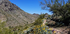


