Mohave Connector Trail #202 begins 0.25 mi along Quartz Ridge Trail #8A from the 32nd Street Trailhead. The trail has a lazy layout, and there are no vicious grades.
From #8A, #202 ascends 165 ft and roughly 0.2 mi west to a ridge. Then the trail eases over to the next canyon. This scenario plays out once again in a stroll grade fashion. Airplane and city noise is typical, like famous nearby peaks. Occasional shade from a Palo Verde is encountered.
Unauthorized use-trails are out of control. Most 4x4 steel posts/signage is strategically placed where junctions are questionable. If you question an intersection, look around for signage. Several posts favor the westbound approach. Eastbound needs to look ahead in two areas.
The grand finale is an easy 120 ft climb to Mohave Trail #200. Upper #202 has Southern views of downtown Phoenix and South Mountain kneeling in front of the Sierra Estrella range.
Synopsis
There are two areas with tread issues that will likely never get fixed. Overall it's pretty good. While I typically approach Mohave Trail #200 on the west end, most access via Quartz Trail #8A and the gated Biltmore neighborhood in the contouring canyons. It's a nice trail in early spring when you need a change of pace.
Gate Policy: If a gate is closed upon arrival, leave it closed after you go through. If it is open, leave it open. Leaving a closed gate open may put cattle in danger. Closing an open gate may cut them off from water. Please be respectful, leave gates as found. The exception is signage on the gate directing you otherwise.
When hiking several trails on a single "hike", log it with a generic name that describes the hike. Then link the trails traveled, check out the example.
WARNING! Hiking and outdoor related sports can be dangerous. Be responsible and prepare for the trip. Study the area you are entering and plan accordingly. Dress for the current and unexpected weather changes. Take plenty of water. Never go alone. Make an itinerary with your plan(s), route(s), destination(s) and expected return time. Give your itinerary to trusted family and/or friends.
Permit $$
None
Directions
Road
Paved - Car Okay
To hike From the West, this trail is accessed via Mohave Trail #200
From the East, this trail is accessed via Quartz Ridge Trail #8A
32nd Street & Lincoln is the closest trailhead via 8A.
page created by HAZ_Hikebot on Feb 08 2010 9:06 pm
 Route Editor

 Mohave Connector Trail #202 begins 0.25 mi along Quartz Ridge Trail #8A from the 32nd Street Trailhead. The trail has a lazy layout, and there are no vicious grades.
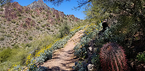


