 Route Editor

| Guide | ♦ | 29 Triplogs | 0 Topics |
details | drive | permit | forecast | 🔥 route |
stats |
photos | triplogs | topics | location |
| 300 | 29 | 0 |
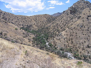
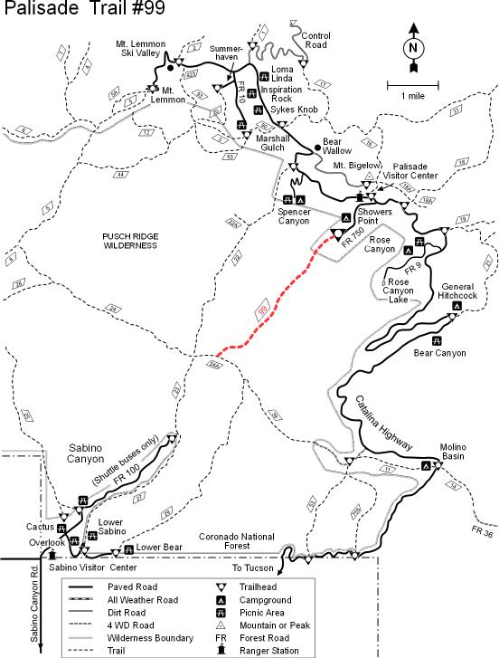
Saguaros to Pines by HAZ_Hikebot   You'll enjoy good views and get a tour of most of the biological life zones which grace the slopes of the Santa Catalinas along this moderate to more difficult trail. From its upper terminus at Showers Point Group Campground, Palisade Trail starts through stands of old-growth ponderosa pine[1] and drops down the ridge which separates Palisade(west) and Pine(east) canyons. Upper sections of the trail are shaded and carpeted with pine needles. Views through the trees extend into both canyons and to the Sabino Basin below. In the distance, the city of Tucson spreads across the broad Tucson Basin. You'll enjoy good views and get a tour of most of the biological life zones which grace the slopes of the Santa Catalinas along this moderate to more difficult trail. From its upper terminus at Showers Point Group Campground, Palisade Trail starts through stands of old-growth ponderosa pine[1] and drops down the ridge which separates Palisade(west) and Pine(east) canyons. Upper sections of the trail are shaded and carpeted with pine needles. Views through the trees extend into both canyons and to the Sabino Basin below. In the distance, the city of Tucson spreads across the broad Tucson Basin.Mud Springs is the only reliable water source along the Palisade Trail and, after dropping into Pine Canyon to visit it, the trail sidehills back to the ridge to treat you to expansive views of Pine Canyon, parts of the central canyons of the Santa Catalinas, and the Front Range. Below Mud Springs, the trail drops into lower Pine Canyon down a two-mile series of steep but solid switchbacks which tend to be brushy and rocky for much of their length. The trail can be hard to find in this area. Watch for rock cairns -- a cairn is a small stack of rocks -- to guide you.
Attractions: A trail full of views, mountains to desert diversity, access to Sabino Basin, wildlife, and a (former)segment of the Arizona Trail! 1) Perhaps scarred, tinged, or torched: 2003 Aspen & 2020 Bighorn
Check out the Official Route and Triplogs. Leave No Trace and +Add a Triplog after your hike to support this local community. One-Way Notice This hike is listed as One-Way. When hiking several trails on a single "hike", log it with a generic name that describes the hike. Then link the trails traveled, check out the example. | |||||||||||||||||||||||||||||||||||||||||||||||||||||||||||||||||||||||||||||||||||||||||||||||||||||||||||||||||||||||||||||||||||||||||||||||||||||||||||||||||||||||||||||||||||||||||||||||||||||||||||||||||||||


