Route Editor

| Guide | ♦ | 35 Triplogs | 0 Topics |
details | drive | permit | forecast | route |
stats |
photos | triplogs | topics | location |
| 209 | 35 | 0 |
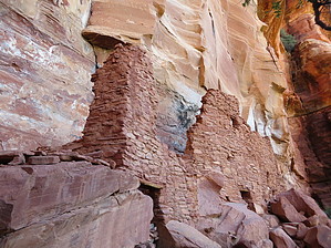
 The ancient Sinagua Indians once lived in north-central Arizona, ranging from the Verde Valley in the south to Flagstaff in the north. Some of the most well known Sinagua sites are preserved as National Monuments, such as Wupatki, Tuzigoot, and Montezuma's Castle. Others lay scattered about the area, from Elden Pueblo, a well preserved Flagstaff area site, to Turkey Hills Pueblo, a mainly eroded mound of rubble. Hundreds of other sites can be found on The Coconino National Forest, and one of the best-preserved is Palatki Pueblo, a Sinagua cliff dwelling located northwest of Sedona. The ancient Sinagua Indians once lived in north-central Arizona, ranging from the Verde Valley in the south to Flagstaff in the north. Some of the most well known Sinagua sites are preserved as National Monuments, such as Wupatki, Tuzigoot, and Montezuma's Castle. Others lay scattered about the area, from Elden Pueblo, a well preserved Flagstaff area site, to Turkey Hills Pueblo, a mainly eroded mound of rubble. Hundreds of other sites can be found on The Coconino National Forest, and one of the best-preserved is Palatki Pueblo, a Sinagua cliff dwelling located northwest of Sedona.Palatki is a Hopi word meaning something like "red house", an altogether appropriate name. It is nestled at the base of Red Rock Canyon's cliffs, a former homesteaded now maintained by the US Forest Service. The first thing you will notice when arriving at Palatki is an older residence, rusted farming equipment, and an orchard. The former homestead now serves as a museum/visitor's center/gift shop for the Palatki complex. Check-in here with the rangers, and make sure that you're on time. The site's visitation is tightly regulated to prevent deterioration.
The site was built around 1150 and abandoned around 1300, based on tree-ring dating, when most of the Colorado Plateau was being abandoned. However, some Sinaguan refugees hung on in the area until around 1450. If you look around the ruin, you can still see some of the original beams used in the construction of Palatki. Some folks speculate that some of the Northern Sinagua moved to the Hopi Villages, and some Hopi stories bear this out. Sinagua is a Spanish word meaning "without water." Obviously, this is not what the Sinaguans called themselves; Some linguists studying the Hopi language speculate that the Hopi word for Sunset Crater, Kana'a, may be the name the Sinaguans called themselves, as the etymology of the word is foreign to the Hopi language. The site was also once much larger than it is currently. Several stories tall when it was constructed, most of the upper stories have collapsed into themselves, leaving mounds of rubble inside the rooms - that's what you're standing on when you're inside the ruin. Some of these rooms have never been dug, and tourists are still finding things popping out of the ground, like sandals, arrowheads, and pots. Please, if you see anything of interest, contact the steward who will help document it. Apparently, the settlers who operated the ranch in the valley had great respect for these ruins, and while they did dig up some artifacts, they left most of the ruin alone. This is one of the reasons why it is so well preserved. After seeing your fill of the cliff dwelling, return to the Visitor's Center, and then take the short Rock Art Trail. Head up the slope behind the VC on the well-maintained trail. It is only about a tenth of a mile, just a quick jaunt. At the top of the trail is a large overhung area, protected from the weather. It is here that the Palatkians created masterful rock art, some of the most beautiful images in the Sedona area. Butterflies, figures, shapes, people, all different types of amazing pictographs. There are two human figures with headdresses similar to Hopi Butterfly Maidens and others with their hair seeming to be in the traditional unmarried Hopi girl's hair whorls, one large whorl on each side. The Sinagua weren't the last ones to visit Red Rocks canyon before the settlers came in the 1800s. The Apaches used to call this valley home before the US Army drove them out. Their rock art also decorates the overhang on the Rock Art Trail, usually simpler figures of horses and some beautiful, complex figures. There is typically a steward on-site at the rock art as well; ask them to point out some examples. If you're into the area's pioneer history, continue along the cliff face to the north, past the rock art, and you will find some more old settlement buildings nestled against the cliff. There is no water along either stretch of trail. Water is sometimes available at the ranger station. When you call ahead to make your reservations, ask about the water status there. The USFS tightly controls this site to limit visitation. If you want to visit, you MUST call to make reservations ahead of time. Sometimes you can call the day-of, but I recommend calling a day or two in advance. The road to the ranch and ruins has a gate that is locked after hours to prevent trespassing. Gate Policy: If a gate is closed upon arrival, leave it closed after you go through. If it is open, leave it open. Leaving a closed gate open may put cattle in danger. Closing an open gate may cut them off from water. Please be respectful, leave gates as found. The exception is signage on the gate directing you otherwise.
Check out the Official Route and Triplogs. Leave No Trace and +Add a Triplog after your hike to support this local community. | ||||||||||||||||||||||||||||||||||||||||||||||||||||||||||||||||||||||||||||||||||||||||||||||||||||