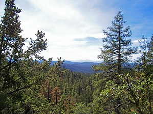
While the Derrick Trail itself is probably not worthy of its own write-up, it does offer some outstanding views of Promontory Butte and the Rim, a good workout, and access to a nice section of the Highline Trail. Most importantly, it is a pleasant change of pace from the usual out and back hike to Horton Spring and should help avoid some of the crowds, especially during the peak summer season.
It's an easy 0.25mi walk between Horton and Derrick Trails along the road. Knock it out first or save it for the end. It is typically easier to find parking at Derrick and it's a kind gesture to leave a space at the more popular Horton Trailhead.
From the Derrick Trailhead, the Derrick Trail heads east/northeast. The ascent is steady, make sure to stop occasionally and soak in the wonderful views of the Rim. As the trail climbs toward Promontory Butte, it becomes lined with Manzanita mixed in with the ever present Ponderosa and Junipers. At 2.5 mi, Derrick intersects the Highline. The right branch continues down the hill and southeast to Christopher Creek. Take the left branch which contours Promontory Butte as it threads its way to Horton Spring.
Take your time, because this is a very pleasant section of the Highline. As a matter of fact, if it wasn't for the beauty of the waterfalls and cascades in Horton Creek itself, this would be the highlight of the loop. The trail gently rises and falls, sometimes a bit steeply, but nothing too taxing. The Ponderosa Pines are close around you and the area retains that euphoric scent of pine pitch in the light high country air. This is Rim hiking at its finest. There also appear to be many young maples and oaks in this section, so this may end up being a fine autumn color hike. Roughly 0.7 mi from the Highline junction, Promontory Trail #268 takes off sharply up the side of the Butte on the right.
After 2.4 miles the trail crosses the dry headwaters of Horton Creek. A half-mile walk down the creek bed will take you to the Horton Creek Trail, coming in from the right. The Official Route for this guide continues on the Highline up the steep hill until you reach Horton Spring. Follow Horton Creek Trail #285 for your return down Horton Creek.
The loop is not much more difficult than the more common Horton Creek out and back, a bit steep and more feisty, but it is very pleasant and it does offer some solitude before reaching the very popular Horton Spring. Make the Spring and the beauty of Horton Creek your reward, and this trail will be worth it!
Original guide 2006 by Mike. 2018 was revised and updated by Joe.
WARNING! Hiking and outdoor related sports can be dangerous. Be responsible and prepare for the trip. Study the area you are entering and plan accordingly. Dress for the current and unexpected weather changes. Take plenty of water. Never go alone. Make an itinerary with your plan(s), route(s), destination(s) and expected return time. Give your itinerary to trusted family and/or friends.
Permit $$
None
Directions
Road
Paved - Car Okay
To Horton Trailhead
From Payson take 260 East for 16 miles to FR289 which is Tonto Creek Road. Turn left on to FR289 and follow a mile to the Upper Tonto Creek campgrounds. Hiker parking is before the campgrounds (left) across a bridge in a small lot. A composite toilet is available.
Horton Creek Trailhead cross back over the bridge and follow the dirt road up towards the campgrounds for about 150 feet. The trailhead should now be apparent on the left.
Derrick Trailhead2015 Update! New trailhead for the Derrick trail about 200 yards before the Horton Spring Trailhead/Parking. There is a large parking lot and new Outhouse opposite the Trailhead.
Note: If the trailhead parking lot is full the campground host may or may not allow you to park for a fee in the campground. It varies year to year so it's good to ask first.
From PHX (I-10 & AZ-51) - 105 mi, 2 hours 2 mins From TUC (Jct 1-10 & Grant) - 203 mi, 3 hours 32 mins From FLG (Jct I-17 & I-40) - 130 mi, 2 hours 32 mins
 Route Editor


 While the Derrick Trail itself is probably not worthy of its own write-up, it does offer some outstanding views of Promontory Butte and the Rim, a good workout, and access to a nice section of the Highline Trail. Most importantly, it is a pleasant change of pace from the usual out and back hike to Horton Spring and should help avoid some of the crowds, especially during the peak summer season.