| | -
| 1 label | 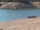 |
|
1 |
-
-
| 1 label | 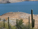 |
|
|
-
-
| 1 label | 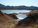 |
|
|
-
| 1 label |  |
|
|
-
-
-
| |  |
|
1 |
|
| | |
|
| Hiking | 3.80 Miles |
850 AEG |
| | Hiking | 3.80 Miles | 1 Hour 23 Mns | | 2.75 mph |
| 850 ft AEG | | | | |
|
|
| |
| Linked |
|
none
[ show ]
| no linked trail guides |
| Partners |
|
none
[ show ]
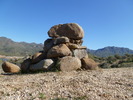
| no partners | | | Last time out, I lost Trail #512 as soon as I stepped foot on it. This time I came equipped with more than a hiking guide book: I not only had a topo I mashed up from the HAZ topo view, but also Al_HikesAZ's GPS route. Funny thing is, I ended up needing neither. (In the case of the topo, good thing because I accidentally left it with my wife.) The trail is very obvious, with a smooth, slightly sandy surface. Narrow, and a bit off camber in spots, but no big deal. Very benign. If you are following Al_HikesAZ's route, keep in mind that it appears to be following the shoreline for about the first mile, not the trail. Weather was sunny and warm, but with a cool breeze, perhaps blowing off the Mazatzal's where you could see snow from Bartlett Lake. I was planning on doing an out & back to SB Cove, but as I did not get started until almost 11:30, decided to bail at the halfway point. (Where my wife met me.) Despite Trail #512 looking relatively smooth on the topo, it's a pretty good blow for a hair under four miles. (If you take the pleasant shortcut through the boulders, otherwise it is about another mile.) FYI: Cell phone reception is very spotty in and around SB Cove. Best bet is to go back up the road for a mile to the info kiosk. |
| _____________________
| http://prestonm.com : Everyone's enjoyment of the outdoors is different and should be equally honored. |
| | |
|
|
|
|
|
| |
 Route Editor


