| | -
| 1 label | 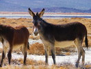 |
|
|
-
-
-
-
-
-
-
| 1 label |  |
|
1 |
-
-
-
-
-
-
-
|
| | |
|
| Hiking | 25.00 Miles |
|
| | Hiking | 25.00 Miles | | | |
| | | |
| |
| Linked |
|
none
[ show ]
| no linked trail guides |
| Partners |
|
none
[ show ]
| no partners | | It's a good trip when you wake up and wonder what day it is. I am sure I have stated this before. Time is your friend and your enemy if you have to return to the workaday world. I wonder if it's thursday or friday. I have no cell service, can't find my clock so just count the camp places with the days. This day I am up to hike to the upper canyon that eluded me a trip before, accessing it from a neighboring canyon with a road all the way to the top of the Panamints. I had thought we would be in this canyon a day and a half. It's now the fourth day.
We've driven to end of spur roads, marveling at the stark rock walls, all the mining remains. When the road ends, hiking boots go on. We've wandered among old camps, from riparian streams to talus slopes, to the forested crest. Looked into shafts, old wells, down and up old cables of trams, great high point views into Death Valley and the Panamint salt pans. Walked into tunnels, climbed ancient ladders covered with drips of candle wax, stared at hand forged tools, held a turn of the century cover for an apple pie box, lit by modern headlamp light, way into the hillsides. But I digress---
We started by spending a day in the Mohave National preserve, near Mitchell Cave, looking for a wild cave nearby and not finding it, but finding an old homestead in a scenic setting, and hiking up a canyon with a surprise natural arch in limestone up on the high walls.
Next we motored into the southern end of Death Valley to the Ibex Springs area, gusty high winds in the evening dictating a protected campsite near massive Talc mine sites.
The day dawned sunny and calm. We wandered around the talc mining area, taking lots of pictures, exploring, the wonderful soft white rock a contrast to the colorful sandy mountains. Some find the mining remains unsightly but I find it fascinating that people tried to make a living this way in such remote areas and in some cases the incredible amount of toughness and ingenuity it took to do it.
We drove a faint road through a low pass to a great alluvial plain. In the distance was a huge sand wall and small dunes hanging in a mountains embrace. The road came near the edge and Brian dropped me off. He was driving on up the valley to some distant mines we could see. I took a lot of water, my camera, my sandals, and I was off.
This sand dune area not noted on my maps. I walked out over the playa. I love dunes. Something about them brings to mind a quote attributed to T.E. Lawrence, author "Lawrence of Arabia"---"the desert is clean".
There was some fading sand verbena. There were subtle areas of blooms, mostly daisies, and I caught some desert five spot too. Here the sand rose in a great wave, and I slowly slogged my way up it. The hills embracing the dunes were colorful, pocked limestone based. Once I made the crest the bowl behind the dune dazzled with mauves and pinks, greens. Almost irridescent. The wind rose and the sand danced. I protected the camera and tracked the edge of the crest, my own dance across. The face fell away steeply but not so bad on the other side. The view out across the valley wonderful too. At the end I traversed and made another ridge. This one was gentler and I needed to get down so bagged the camera, sat on my butt, lifted my feet and slid all the way to the bottom, laughing and screaming as I went. A single raven circled overhead I am sure puzzeled at my performance.
I wandered at the base, then got to the road to watch Brian taking the FJ through it's paces coming back to pick me up. I found a few flowers to look at and of course many rocks. I am sure if I lived near Death Valley and hiked here every single day for a year I would see maybe 10% of it all.
We leave the Ibex area, on to the southern end of the West Side road in Death Valley proper and to go through the Panamints using Warm Springs Canyon and Goler Wash, a reverse of a trip I completed about 10 years ago on one of my first driving explorations. This time we spend more time out of the car, again at the huge Talc mining complexes, the amazing miners "resort" of Warm Springs, and as I did years ago we drew some of the warm water in the portable shower rig, tied off to a tree and cleaned up.
Up the canyon we took a rough spur to the Gold Hill area, one of the oldest gold mining areas in Death Valley, in some of the oldest rock exposed in the park, about 1.7 billion years. We saw some of the first of several large herds of wild burros, one group we counted 25 individuals, including some young ones.
On to nearby Striped Butte Valley, probably one of my favorite areas in the southern part along with Ibex Springs. The gentle swale is graced by a layered "striped" butte. Three notable cabins are in the area, all available to stay or camp near first come first served. This time we picked Geology cabin as headquarters, neat as a pin and on a high point with an enviable view. The sunrise here was glorious. I just sat in my chair, sipped my coffee and shot pics or just relaxed. Couldn't be more perfect. We visited the other cabins, Stellas' Place and Russel Camp, but they didn't have the view of here.
Normally this valley is quite popular, visiting during the week highly recommended to avoid the four wheel drive crowds.
We left by Mengle Pass near Manly Peak. The roads had been pretty mild up until now, Brian had to spot me over some boulder walking up over the pass.
The road over the top to Goler Wash has some "character". We went to a great overlook then down into the wash. We stopped at Barker Ranch, notorious for the brief stay of Charles Manson and his followers, and here they were taken into custody for vandelizing park equipment; however they had already committed the Tate LoBianca murders.
The ranch is slowly deteriorating, a shame since it is in such a lovely setting, near a spring and in a beautiful rocky canyon. We drove several side canyons down and explored off a spur road to some mining claims. It was nice to get out of the Cruiser as we could. On down a lofty tram perched on a rocky peak caught Brians eye and he decided to climb about 500 feet up, I took a nap in the sun and watched the chuckwalla's, just a bunch of them seemingly on every other large rock.
Brian made it back via an old trail he found and off we go again. We exit Goler, the last exciting narrows barely wide enough for the vehicle, onto the huge dry lake beds of the Panamint playa. We drive north toward our next canyon destination, detouring to Trona for gas and water.
Up Pleasant Canyon we go. Yes, we were here for four days. We walked a miner's burro trail to some small guage rail tracks laid on the side of a cliff about 1000 feet above us, the history of this mine late 1800's, the cut in trail as good as any in any park system, kept up by the wild burros. It was scary up at top and the mine short and uninteresting, but I loved the little informal trail.
Next we visited Clair Camp and the Ratcliffe mine. We camped near the World Beater cabin, in fair shape, with a huge deck and new outhouse. Another great top of the canyon view. The old mine was extensive and interesting. Higher, into the low pines, then more roads, and more mines, and more to see. We took one road to the crest of the Panamints, the views just incredible, and me nervous with the FJ pointed at severe uphill and downhill angles. We drove through middle park, and back into Pleasant. I launched my hike from here, Brian tired and just wanting to take a day to relax.
My little hike did not fulfill my goal, but was wonderful and successful all the same. Because I had a time limit I didn't get to the cabin I sought, but I was close, so again a thing to do another time. I hiked in a great bowl in an not so old burn, with some snow covered mountains around me, and a great bare peak ahead of me, and rocks everywhere. Another "zen" like experience.
Finally we wandered toward Wildrose and looked at the Charcoal kilns, up over Emigrant Pass, and down into the valley to once again camp off the West Side road up Trail Canyon. Time was running out. We drove up and hiked up Johnson canyon, a Deja-vu for me, just to Hungry Bill's old ranch with it's extensive rock walls and a few fig trees gone wild. A large storm was fanning out over the Panamints and we ran away to camp again at the Ibex area. I wanted the dunes again there but the winds and cold drove us onward. A real treat to drive across the mohave with snow coating the Joshua trees and making the driving rather interesting.
So, I am here again and dreaming the dream of the other places, and will just have to be content with this experience and the pictoral record. I guess I could do worse. |
| _____________________
| | |
|
|
|
|
|
| |
 Route Editor


