| | -
| |  |
|
1 |
-
-
-
-
-
-
-
-
-
-
-
-
| |  |
|
4 |
|
| | |
|
| Hiking | 4.00 Miles |
500 AEG |
| | Hiking | 4.00 Miles | 3 Hrs | | 1.33 mph |
| 500 ft AEG | | | | |
|
|
| |
| Linked |
|
none
[ show ]
| no linked trail guides |
| Partners |
|
none
[ show ]
| no partners | | Government Knolls on Government Prairie
Lynn and I went up to Flagstaff to visit Hannah and see her new condo apartment in Highland Village and drop off some of her items she had in storage. Also went up to get Skippy and Pauli out into the country to stretch their legs. Government Knolls on the northern side of Government Prairie were on the agenda...
Took the I-40 west out of Flagstaff to Exit 185 "Transwestern Road - Bellemont" and continued along the northside frontage road which happens to be remnants of Route 66. Travel about 7 miles until you reach Government Prairie Road - FR107. Head north on FR107 about 5 miles until you see a Y-intersection double track heading east near Rain Tank Hill. This is FR730/793. There is not signage near the intersection, but as you progress east along the double track you will see faded Forest Road signs indicating FR730 or FR793. You will come to a fork in the road on the northern side of Rain Tank Hill with the namesake rain tank visible to the south. Take the left fork heading towards the cattle fence.
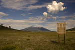
Pass through the gate (note the sign requesting that you keep the gate closed - "Loose cows eat cars") and onto the expanses of Government Prairie. About a ¼ mile past the gate you cross the Historic Beale Wagon Road. There used to be a posted sign with the ubiquitous camel emblem denoting the wagon road - don't know where it's gone...
We continued along FR730/793 towards Government Knolls testing out my new shocks and ball joints on the F-150. At the signage near Horseshoe Tank and the base of Government Knolls, we parked the truck and began a hiking circuitous route up to the top of the knoll.
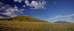
There were plenty of wildflowers with threatening clouds near Sitgreaves Mountain and beyond Kendrick Peak. At the top of the knoll is a fantastic payoff -- stellar 360 degree views with the San Francisco Peaks to the east, expansive Government Prairie to the south, Sitgreaves Mountain to the west and Kendrick Peak to the north. Worth just sitting there taking it all in... |
|
Wildflowers Observation Substantial
|
|
| _____________________
| | |
|
|
|
|
|
| |
 Route Editor


