| | -
-
-
-
-
-
-
-
-
| 1 label | 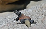 |
|
|
-
-
-
-
-
-
|
| | |
|
| Hiking | 1.10 Miles |
132 AEG |
| | Hiking | 1.10 Miles | 34 Mns | | 1.94 mph |
| 132 ft AEG | | | | |
|
|
| |
| Linked |
|
none
[ show ]
| no linked trail guides |
| Partners |
|
[ show ]
| partners | | We were able to find parking again and ended up adjusting so that another car could park in the same parking spot. It was going to be crowded. We hiked between rock walls into Hidden Valley. After climbing over and through this gap in the rocks enclosing the valley, we reached a sandy desert floor and a T-junction. We encountered more of the fabulous geology featuring monzogranite all over the place except now, you were completely surronded by it. And on top of that, you got a mixture of low and high desert trees and shrubs. A lizard scampered in front of Kelly and then we saw a chuckwalla. This is quite the bowl of views you enter and hike around. There are some nice interpretive signs.
I did a lot of filming; sometimes it just seems easier as you just can't take it all in all at once. This way, I can see it more when I get home and start editing. According to the interpretive sign: per family history, in 1936, just months before Joshua Tree National Monument was established by President Franklin Roosevelt, Bill Keys blasted the opening through which you have passed into Hidden Valley. Because the valley had been secluded for so long, the native bunch grass was lush and plentiful. It seemed a perfect place to pasture cattle.
I read this great comment: it's no wonder the place was used as a natural corral. Nothing could get out!
I really didn't know what to expect but enjoyed our clockwise trip around the cirque. Even with all the people it felt quite secluded in places. There was great scenery to keep your eyes darting all around and quite a few climbers of all levels. I didn't realize what a climbing mecca this park was but it sure makes sense now. You stay pretty close to the outer walls of granite boulders. There was mixed vegetation (Joshua Trees, Pinyon Pines, Junipers and Oaks are the taller denizens of the valley, but there's plenty of room for the mesquite, nolina, yucca, cacti, catclaw, creosote and other species) scattered all about too and that is because of the special climate and rock features, it is a transition zone between the Joshua tree forest and the pinyon-juniper woodlands.
And once you start closing the loop the area becomes tighter with flora and boulders and you snake around and up and down a bit to get back to where you started the loop part of the hike. There was a bit of a breeze which felt good. Before heading back down the small hill I snapped a picture of all those Joshua Trees in the valley before me and Ryan Mountain in the background so that was a great ending for this hike.
I shot a lot of movies for this video too: [ youtube video ] |
| _____________________
For me, sometimes it's just as much about the journey as the destination.
Oh, and once in awhile, don't forget to look back at the trail you've traveled. |
| | |
|
|
|
|
|
| |
 Route Editor


