|
| | | |
| |
|
| Hiking | 7.00 Miles |
2,500 AEG |
| | Hiking | 7.00 Miles | 7 Hrs | | 1.17 mph |
| 2,500 ft AEG | 1 Hour Break | | | |
|
|
| |
| Partners |
|
[ show ]
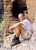
| partners | | Back in April of last year, I made my first attempt to do this hike. At that time it was me, Mike, and my co-worker Gordie, who has done Keet Seel as well as some hikes in the Superstitions. We got about 3 miles from the trailhead, just past Ellison Ranch, when I got a flat tire. It was right before the really gnarly section of Cherry Creek Road. We put on the spare, which was nearly flat, and made the slow crawl, 20 miles back to asphalt. Once we got air in the spare in Globe, we got home ok. It was already late in the year to try to go back since things were beginning to heat up. After waiting 10 months, this would be the day I would go back to get this hike done  . This time it was me, Wally, Mike, and Mike’s buddy Andy. . This time it was me, Wally, Mike, and Mike’s buddy Andy.
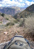
It was a pretty solid 3 hour drive to the “trailhead”, which is basically one parking spot on the side of the road, which got us started at about 7:30am. It was still pretty chilly when we got out of the car, but by the time we got to the junction to go over to Cold Spring, everyone had taken off their sweatshirts/jackets/flannel. The forecast for the day was a high of 68, but it easily seemed to be 80 by the time we were done for the day. It was noticeably cooler in the shade, but never to what could be considered chilly.
Just past the junction on our way over to Cold Spring, we saw a very young calf laying down off the trail. We got a few pics and a closer look. Mama was eyeing us from behind some bushes (so I was told, I never saw her). The fur looked wet enough that this was likely a newborn. Sadly, something seemed wrong with it as it didn’t even have the strength to stand. On our way back, it was still lying there. 
We spotted the crack house ruin along the trail and made our way underneath it. Then we found the spot where you start to ascend up to it. This was one of the rougher parts of the day. It’s very steep on the way up, and the ground is loose. There is a lot of vegetation, but it’s very useful to hang onto to pull yourself up and hold onto to keep from falling on the way down. Except for the prickly pear cacti, those you had to make sure you avoided. Andy had a spill early, but no major injuries or broken bones like his incident on Camelback last year. Just below the ruin is a tree that’s grown across the trail that requires some flexibility to maneuver up, around, under and through. This was not the easiest thing to do as middle age approaches and a full back is on your back  . The rest of the hike would prove to have many sections like this. . The rest of the hike would prove to have many sections like this.
Having read the triplogs from last year, I knew that there was a bees nest present in the spring of 2015. I warned Mike about that as he entered and he mentioned, in a somewhat concerned tone of voice, that there were a huge amount of flies inside. I was the third to enter, and as I did, it was odd at how all the flies were zooming out of the front door away from everyone. By the time we all entered, they were all almost gone.
Inside the crack house ruin was very cool. It took some effort to try to figure out how to access each level with the X-formation logs without falling, but we were all able to handle it. The big payoff for this ruin is the balcony in the upper level, which gives a very nice view of the adjacent mountain, as well as the sheer drop on the other side of the 700+ year old wall  . Before I ascended to the top level, I went into the room under the floor and got a look at how it’s put together. For as old as it is, it’s in good shape, but it’s still just sticks and mud that was holding our collective body weight from crashing down. If you tap your foot on it, you can hear the hollow thump from the room below . Before I ascended to the top level, I went into the room under the floor and got a look at how it’s put together. For as old as it is, it’s in good shape, but it’s still just sticks and mud that was holding our collective body weight from crashing down. If you tap your foot on it, you can hear the hollow thump from the room below  . .
Once we were done, we made our way back to the trail junction and on to Pueblo Canyon. The ascent up the canyon seemed brutal. The ground wasn’t nearly as steep or loose as the short ascent into the Cold Spring crack house ruin, but the thick vegetation still made for a lot of maneuvering. Also, while my recent hiking has involved a lot of distance, it has not involved much elevation gain. This was Mike’s second time into Pueblo Canyon, and he said he didn’t remember it being so difficult his first time  . .
Once were level with the ruins on the north side of the canyon, the difficulty of the hiking wasn’t done. The trail maintains the same average elevation, but is in no way really level, as it goes up and down, up and down around trees, boulders and terrain. In addition to the inherent level of difficulty, someone who recently hiked both of these trails decided to do quite a lot of trimming to the surround vegetation. This would have been ok, other than the fact that all that vegetation was just left on the ground, which made for quite a few tripping and slipping hazards   . The closer we got to the waterfall, the easier the trail became, with less ups and downs and choked vegetation. At one point along this section on the south side of the canyon, my foot caught on a tree root, and I almost fell forward over the edge of the trail. There are a few sections here where there is a little exposure. Looking across to either side of the canyon from which side you’re on, it’s easier to see how much exposure there really just beyond a lot of the vegetation that surrounds you on the trail. If you fall and the trees and bushes don’t catch you, you could easily be in a lot of trouble . The closer we got to the waterfall, the easier the trail became, with less ups and downs and choked vegetation. At one point along this section on the south side of the canyon, my foot caught on a tree root, and I almost fell forward over the edge of the trail. There are a few sections here where there is a little exposure. Looking across to either side of the canyon from which side you’re on, it’s easier to see how much exposure there really just beyond a lot of the vegetation that surrounds you on the trail. If you fall and the trees and bushes don’t catch you, you could easily be in a lot of trouble  . .
The first ruins on the south side of the canyon were ok, nothing special. There’s a couple walls left that are built into the ground on the edge of the canyon, holding back from a sheer drop. Inside the main building, the fingerprints in the mud are still visible, very similar to what’s at Devil’s Chasm. The front wall of this one seems to have fallen down outwardly and over time sediment has filled in the rocks, that now stick out of the ground all lined up. It’s easy to miss if you don’t look closer. The mine tunnel entrance is also nearby. I took a look in, but didn’t feel the need to go inside and explore. Looking across the canyon, all three ruins on the north side were visible, which made for a similar look to Walnut Canyon near Flagstaff.
The waterfall was running with a good amount of flow. It reminded me of Ribbon Falls in the Grand Canyon a little bit. We all took turns getting various photo shots from various angles as we passed it. Walking behind it was nice feeling the cold rush of air and some mist  . .
The three sets of ruins on the north side of the canyon are all very interesting. The middle set has a 2 level room that the floor has fallen down on one side, revealing the layers of beams, sticks and mud that it’s made of. In these ruins it was possible to find some pottery shards if you did any amount of looking. I quickly found a couple pieces and put them on a rock to make them more visible for the next visitors. Wally pointed out to me some he found that were similarly put out, as well as a little cubby hole shelf inside one room that had a whole pile of shards. In the 2nd and 3rd sets, there are quite a lot of patches in walls that are easy to see from the different colored mud. It’s also easy to see spots where the style of construction suddenly changes along a wall, indicating some sort of rebuild at some point.
Looking at these sets of ruins from the south side of the canyon, it looks very easy to walk from set to set, but in fact it’s almost as difficult as the rest of the hike. It’s a little more open, but the ground still has a lot of obstacles to step over and the trail meanders up and down around boulders and terrain. At one point, the trail descends and ascends around rock and vegetation. In this little dip, the ground is very loose and steep, and at the bottom, it opens a bit to some thin vegetation. From the south side, it was easier to see how just below that thin vegetation was sheer drop off of several hundred feet .
We all made our way back to the car safely without incident, other than the typical scrapes, bruises and cactus needle sticks. We finished up at about 2:30pm, making for a total of 7 hours, including all our time for stopping to get photos, exploration and lunch.
I had Route Scout running and my Garmin Oregon to record the track. Once were inside Pueblo Canyon, both lost satellite signals, resulting in a zig zaggy track from each. In some cases, the zig zagging was nearly identical in the same spots. For mileage I’ll just go with posted routes that seem to list it at 6.8.
Having been to Mesa Verde two summers ago, doing a hike like this gives the impression of how manufactured the NPS sites are to some extent, mostly in terms of how much infrastructure is added for accessibility. Getting to these ruins is not easy, and it was obviously not meant to be. Maneuvering our way through the natural state of an unmaintained trail is quite a different experience from walking along a paved path at a gentle slope. I appreciate both experiences, but I like doing a hike like this to have a sense of exactly how much is done by the NPS to maintain the ruins they do. It was a very long day and a lot of work, but as usual, getting out to the Sierra Anchas is always worth it  . . |
| _____________________
| | |
|
|
|
 Route Editor


](https://hikearizona.com/dex2/images/smilies/eusa_wall.gif "Brick wall")
 Oh well; I guess that will be part of the memory of the trip ....