|
| | | Four Peaks Circumference, AZ | | | |
|
|
Four Peaks Circumference, AZ
| | |
| |
|
| Hiking | 30.73 Miles |
7,770 AEG |
| | Hiking | 30.73 Miles | 23 Hrs 36 Mns | | 1.54 mph |
| 7,770 ft AEG | 3 Hrs 41 Mns Break | | | |
|
|
| |
| Partners |
|
[ show ]
| partners | | Synopsis: 4PC - A Long Day's Journey Into Night...And Morning (TL;DR Version)
Joe posted a wish list hike for a repeat of the Four Peaks Circumference that he and Karl hiked in March 2014. It was 100% new terrain for me, and I can't seem to turn down opportunities for long loops with poorly maintained/non-existent trails, so I signed up. Joe and Karl completed the loop in ~16.5 hours, and Joe figured we could finish in 15-20 hours. What could go wrong? Nothing did, per se, it just took a lot longer than planned. The eastern side of the loop following Alder Creek slowed us down; we ended up covering nearly half the total miles, most of the elevation gain, and the worst of the brush in darkness as we hiked all of Saturday and into Sunday morning.
The Details
Joe and I left the valley ~3:40AM on Saturday for the drive to Mud Spring Trailhead. There were a couple of deep ruts in FR143 on the way in and some moist spots in the washes that we hoped were a good sign for water along the route. We set out at 5:30AM hiking uphill by moonlight on FR 143, starting our clockwise circumference.
We had comfortable temps starting out and a nice sunrise over Roosevelt Lake and the Sierra Anchas with Four Peaks ahead of us as we approached Lone Pine Trailhead ~ four four miles in. We continued on Four Peaks Trail, enjoying the last maintained trail we'd see on the loop. We passed two hunters glassing the hills on the our way to Black Bear Saddle, where we found their camp--sleeping bags, food, water, and equipment were scattered around there.
We took a short break before the real fun started, dropping down to Alder Creek for the non-existent trail portion of the loop. We had a steep, loose, brushy descent down to the creek, but we made it down relatively quickly and started following the creek south. It was flowing nicely in many places, with pools and small falls...but also a lot of brush, including poison ivy. Our pace slowed considerably following Alder Creek, and we ended up spending most of our daylight hours on that six-mile stretch. Both of us stepped in quicksand (multiple times for me) and had soaked and sandy footwear.
We left the creek bed for a steep scramble up and over a ridge to get around some obstacles in the canyon and planned to take a longer at break Karl's swimming hole from 2014 [ photo ] . Despite plenty of water in the creek, there was no swimming hole--we saw no sign of deeper pools, so floods have probably rearranged the creek bed in the past 11 years. We took a 45-minute break in that general area to recharge electronics, eat, and filter water before resuming the long hike down Alder Creek.
Joe mentioned making a quick stop at Brown's Cave since it was only ~50 yards off our route, and I'd had that on my list for years. That part of the canyon approaching the Salt River Corridor was beautiful, with healthy saguaros and taller canyon walls, but by the time we got close to the cave (less than 500'!), darkness was closing in fast, and decided to skip it because we wanted to navigate through the jungle of brush to find our route west while we still had some light left.
Joe remembered relatively easy hiking for the rest of the route from his 2014 circumference, but it's either become more overgrown in the past decade, and/or he repressed the memories of what we still had ahead of us  . When we pulled out our headlamps/flashlights after sunset, we still had 13+ miles and 4,000' to 5,000' AEG remaining; clearly we had a long evening (and morning) ahead of us. Unfortunately, Joe also told me I was missing some of the most scenic geology of the loop . When we pulled out our headlamps/flashlights after sunset, we still had 13+ miles and 4,000' to 5,000' AEG remaining; clearly we had a long evening (and morning) ahead of us. Unfortunately, Joe also told me I was missing some of the most scenic geology of the loop ](https://hikearizona.com/dex2/images/smilies/eusa_wall.gif "Brick wall") . .
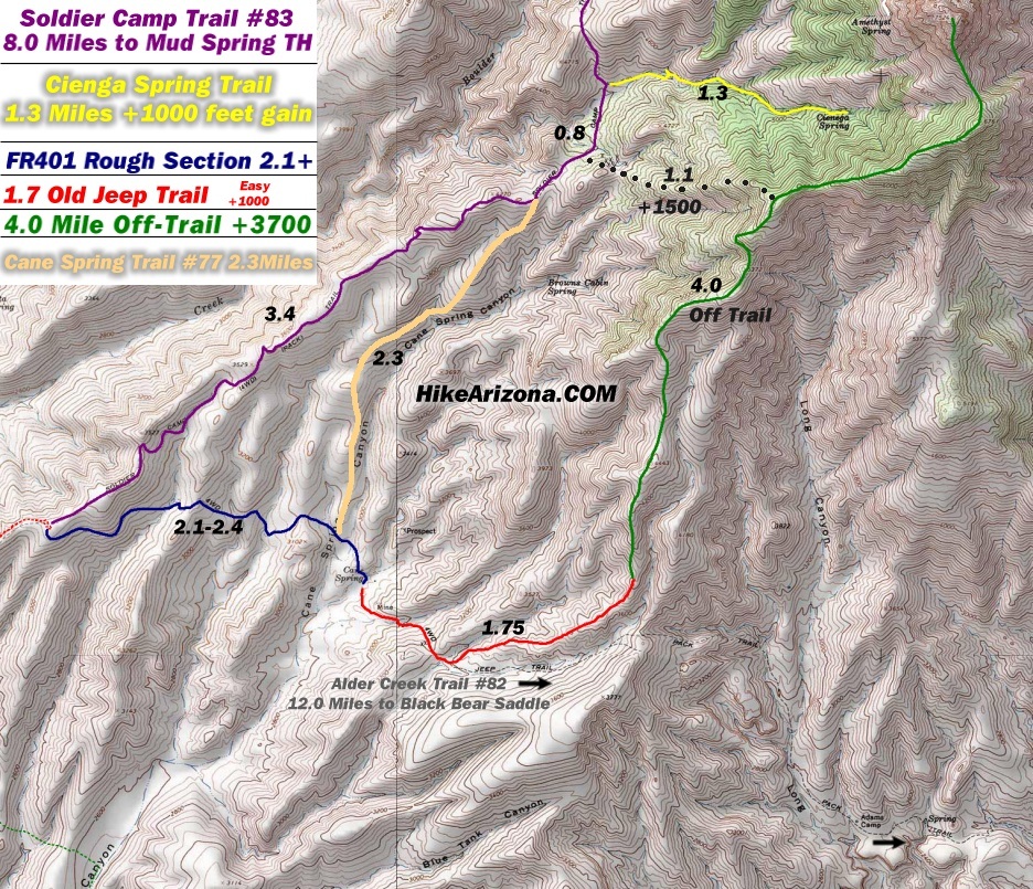
Our world quickly shrank to the Route Scout screen and what we could see in our flashlight beams. I had a flashlight in one hand and my phone in the other as I navigated, conjuring Lion Mountain flashbacks. We had sporadic stretches of relatively open hiking with a cairned route, but more often we dealt with a lot of brush as we headed toward Cane Spring Trailhead, especially around Paint Spring and Adams Camp Spring, where we saw the remnants of the chimney at the camp.
We had some easier, more unobstructed hiking around Cane Spring and the trailhead and were surprised to run into someone out there with a truck. We chatted briefly as we passed; he seemed to know the area pretty well and was surprised we were out there hiking with a long way still to go get back to Mud Spring Trailhead, ~ eight rough miles with a lot of elevation left to gain. Joe and I took another break just after we reached Cane Spring Trail as the moon rose over Four Peaks and gave us a little more light.
The rest of the hike was a bit of a blur as the clock passed 10PM, then midnight; the hours flew by, the miles crawled by. Joe wasn't feeling great and was battling cramps, so I carried his backpack for the last five miles. The open stretches were a relief but never lasted long enough, and there were some brutal stretches with steep, loose, and brushy uphill climbs as we followed Joe and Karl's old route.
We encountered the worst brush with 3-4 miles left...everything I could see in the flashlight beam anywhere close to the general direction we needed to go was a wall of catclaw. I'd done pretty well avoiding scratches up to that point, but my legs got absolutely shredded through that section, and our progress was measured in hundredths of a mile whenever I checked Route Scout. On the bright side, if the brush didn't let up, our progress would only get easier because we'd be finishing the loop in daylight.
We had to cross two large drainages along Solider Camp Trail that were reasonably well cairned, then pushed through a long final uphill climb with strong winds on our way up to Big Saddle. Somewhere in there, I noticed an odd streak of white in my flashlight beam, with deep black shadows on either side. I went in for a closer look and realized I was approaching a skunk; fortunately, it decided to run rather than spray.
We had a steep descent from Big Saddle, but the route was mostly cairned and easier to follow than much of what we'd been through. Within 50 feet of the trailhead, I stepped into a muddy swamp around Mud Spring without noticing it in the dark...didn't feel too great with the cuts all over my legs. That was the final gift this loop had to offer; we got back to the truck just after 5AM, completing our lap of Four Peaks in roughly a lap around the clock .
Sunday's sunrise brought things full circle on the drive out FR 143, making that my first day hike that included two sunrises and a sunset. When I finally got back home around 7:30AM, I took a shower and immediately went to bed after 29 hours awake, ~24 of those hiking. The length of the hike really threw off my sense of time--it felt like Saturday night had disappeared into a black hole.
Overall, it was a memorable day(s). When it comes to rough off-trail hiking after dark, today made Lion Mountain feel like a day at the zoo. Coincidentally, I lost my sunglasses on the Lion hike, and Joe lost his on today's hike. But I learned from the Lion experience: don't ever help Joe across anything, leave the bear spray at home, and pack your sunglasses away when it gets dark, don't just hang them from your collar  . This one took longer than either of us expected, but there were no injuries or medical problems, so I'll call it a win. To quote Joe's 2014 triplog: "Never say never, it 'seems' unlikely I'll redo this loop." . . This one took longer than either of us expected, but there were no injuries or medical problems, so I'll call it a win. To quote Joe's 2014 triplog: "Never say never, it 'seems' unlikely I'll redo this loop." . |
  |
Alder Creek - Four Peaks |
Pools to trickle |
Pools to trickle |
| |  Light flow through much of the creek from Black Bear Saddle down to the Brown's Cave area. Less water at the southern end at the marked spot on the map (only small, stagnant pools) Light flow through much of the creek from Black Bear Saddle down to the Brown's Cave area. Less water at the southern end at the marked spot on the map (only small, stagnant pools) |
 |
Alder Creek - South Swim Hole |
Dry |
Dry |
| | | No sign of the actual swimming hole. Decent flow of water through most parts of Alder Creek, with lots of pools and small falls (and lots of algae) |
|
Mud Spring |
Dripping |
Dripping |
| | | Water in the spring box; swampy/muddy ground in the vicinity. |
|
Shake Spring |
Dripping |
Dripping |
| | | Medium pool with clear water and algae | | | |
|
|
|
 Route Editor


