username
X
password
register
for free!
help
ArticlesGuidesRoutes
 
Photosets
 
 Comments
triplogs   photosets   labels comments more
Boulder Canyon Trail #103 - 107 members in 509 triplogs have rated this an average 3.8 ( 1 to 5 best )
1, 2, 3, 4, 5 ... 26  Next
509 triplogs
login for filter options
Feb 16 2026
avatar

 Routes 3
 Photos 40
 Triplogs 5

female
 Joined Jan 04 2026
 Mesa, Arizona
Boulder Canyon Trail #103Phoenix, AZ
Phoenix, AZ
Hiking avatar Feb 16 2026
polly__crochetTriplogs 5
Hiking4.00 Miles 1,500 AEG
Hiking4.00 Miles   3 Hrs   1 Min   1.52 mph
1,500 ft AEG      23 Mns Break
 
1st trip
Linked   none no linked trail guides
Partners partners
PatrickL
Boulder Canyon trail was beautiful on this gorgeous winter day. We had quite a bit of cloud coverage and the scenery was outstanding. At around 2.5 miles we turned around because the pup was tired, however this trail keeps going for another 5.5-6ish more miles. Family friendly and dog-friendly. I also spotted lots and lots of flowers, plants and even some Big Horn sheep on the drive out (but really close to the trailhead). The drive itself out to the hike is lovely and windy.
wildflower observationwildflower observationwildflower observationwildflower observationwildflower observation
Wildflowers Observation Extreme
 
229445
Feb 16 2026
avatar

 Guides 7
 Routes 87
 Photos 2,586
 Triplogs 668

male
 Joined Jan 10 2010
 Pomona, CA
Boulder Canyon Trail #103Phoenix, AZ
Phoenix, AZ
Hiking avatar Feb 16 2026
PatrickLTriplogs 668
Hiking3.90 Miles 983 AEG
Hiking3.90 Miles   3 Hrs   1 Min   1.48 mph
983 ft AEG      23 Mns Break12 LBS Pack
 no routes
1st trip
Linked   none no linked trail guides
Partners partners
polly__crochet
Out & back on Boulder Canyon, good weather and not too crowded. Gotta come back for the whole trail sometime. For some reason this is only like the second hike I've ever done in the Superstitions - serves as a great introduction to a place I knew would deliver the goods.
_____________________
  1 archive
229457
Feb 14 2026
avatar

 Guides 94
 Routes 848
 Photos 22,732
 Triplogs 2,040

52 male
 Joined Sep 18 2002
 Tempe, AZ
Boulders Horses and Barges, AZ 
Boulders Horses and Barges, AZ
 
Hiking avatar Feb 14 2026
chumleyTriplogs 2,040
Hiking15.19 Miles 2,296 AEG
Hiking15.19 Miles   6 Hrs   38 Mns   2.44 mph
2,296 ft AEG      25 Mns Break
 no routes
1st trip
It was 3 years to the weekend since we did this one last and unsurprisingly, the 2026 edition was considerably drier. Still, there was plenty of water along the whole loop, but it was possible to make it without getting your feet wet on this day. Next week? Much less likely.

Fall rains and springlike January temperatures have grown this summer's kindling to kneedepth. I must say, barren moonscape looks so much nicer when carpeted with invasive green weeds. Borderline pleasant.

A handful of groups on the first mile of BCT103, a couple with a dog in the box, not a soul across Cavalry, three groups along Boulder creek, and two camped near 2nd water. To nobody's surprise, none more until reaching the paddleboards at the lake.

Cooler than last weekend, still a bit warm in the sun. Purposefully sought out shade for our breaks. Thanks for being my valentine 9L. Again. :? :sweat:
 Flora
 Flora [ checklist ]
[ checklist ]  Owl Clover
wildflower observationwildflower observationwildflower observationwildflower observationwildflower observation
Wildflowers Observation Light
100% more substantial than anywhere all of last year.

water 1 out of 5water less than maxwater less than maxwater less than max Boulder Canyon Pools to trickle Pools to trickle

dry Boulder Creek - Superstition WA Dry Dry
Mostly dry with one nearby pool at the Cavalry junction

water 1 out of 5water less than maxwater less than maxwater less than max Boulder Creek at #103 / #236 Jct Pools to trickle Pools to trickle

water 1 out of 5water 2 out of 5water less than maxwater less than max La Barge Box Light flow Light flow

water 1 out of 5water 2 out of 5water less than maxwater less than max La Barge Creek Light flow Light flow

water 1 out of 5water 2 out of 5water less than maxwater less than max La Barge Creek - E of Battleship Mtn Light flow Light flow

water 1 out of 5water 2 out of 5water less than maxwater less than max Second Water Canyon Light flow Light flow
_____________________
I'm not sure what my spirit animal is, but I'm confident it has rabies.
 
229424
Feb 10 2026
avatar

 Guides 112
 Routes 2,442
 Photos 9,563
 Triplogs 2,793

45 female
 Joined Dec 24 2007
 Ahwatukee, AZ
Marsh Valley LoopPhoenix, AZ
Phoenix, AZ
Hiking avatar Feb 10 2026
LindaAnnTriplogs 2,793
Hiking17.29 Miles 2,695 AEG
Hiking17.29 Miles   7 Hrs   49 Mns   2.51 mph
2,695 ft AEG      56 Mns Break
 
Route Scout Route recorded on Route Scout | Pop | Map | Popup | MapDEX
Supes day today. We got started from First Water around 0715. Warmish temps to start, but some high clouds. Took Dutchman to Bull Pass, then Bull Pass up to Black Top Mesa. The moments of shade were nice. Nice break atop the mesa, with a good breeze.

Continued east on Bull Pass, a moment on Dutchman again, then north on Cavalry. The east half of Cavalry could use some work. The trail is vague and brushy in spots. At one point, Kelly was leading, and she stopped abruptly and said “cameras.” We obeyed immediately and got some nice pics of a Gila monster on the trail. He looked a bit underfed. Lunch break in some shade, then the western half of Cavalry was in better shape. I wished the breeze had stuck around. Saw two sort of lost hikers. We provided no helpful information.

North on Boulder Canyon. West on Second Water to finish the loop. I never like the rocky sections of Second Water. Saw five backpackers. Overall, a very quiet day. Great hike and company. Fun day.
 Fauna
 Fauna [ checklist ]
[ checklist ]  Gila Monster
wildflower observationwildflower observationwildflower observationwildflower observationwildflower observation
Wildflowers Observation Moderate
Plenty of flowers.

water 1 out of 5water less than maxwater less than maxwater less than max Boulder Creek at #103 / #236 Jct Pools to trickle Pools to trickle
Plenty of water in Boulder Creek
_____________________
Stop crying and just go do the hike.
 
229311
Feb 10 2026
avatar

 Guides 10
 Routes 700
 Photos 7,591
 Triplogs 4,843

67 female
 Joined Nov 17 2008
 phoenix, az
Marsh Valley LoopPhoenix, AZ
Phoenix, AZ
Hiking avatar Feb 10 2026
trekkin_geckoTriplogs 4,843
Hiking17.19 Miles 2,610 AEG
Hiking17.19 Miles   7 Hrs   48 Mns   2.58 mph
2,610 ft AEG   1 Hour   9 Mns Break
 
Route Scout Route recorded on Route Scout | Pop | Map | Popup | MapDEX
met up with linda and bruce around 0715 at first water
the initial objective was black top mesa, then to be determined
dutchman, bull pass and up the well defined use trail to btm
such a great spot with 360 views of the superstitions and some inscriptions to hunt for
we took a break here just enjoying the surroundings
back down to bull pass, we decided to complete the marsh valley loop
nice to see things from the opposite direction
cavalry trail is kind of a mess from fire and flooding
we spotted a gila monster on the trail
took a lunch break along the way
dropped into boulder canyon and finished up on second water
nothing like a big uphill at the end of a long day
good combo of a classic loop and a high point
thanks for inviting me! always good to hike with linda and bruce :)
_____________________
hazhole
  1 archive
229318
Feb 10 2026
avatar

 Guides 42
 Routes 1,770
 Photos 15,433
 Triplogs 2,897

69 male
 Joined Jan 20 2009
 Far NE Phoenix,
Garden Valley LoopPhoenix, AZ
Phoenix, AZ
Hiking avatar Feb 10 2026
The_EagleTriplogs 2,897
Hiking17.73 Miles 2,620 AEG
Hiking17.73 Miles   7 Hrs   49 Mns   2.61 mph
2,620 ft AEG   1 Hour   1 Min Break10 LBS Pack
 
1st trip
Route Scout Route recorded on Route Scout | Pop | Map | Popup | MapDEX
It had been eight years since I’d been up on Black Top Mesa, so it was definitely time for a return trip. We had a couple of loop options in mind and decided on the Marsh Valley loop after descending from the Mesa. The temperatures were pleasant throughout the day, with filtered clouds fending off the sun's stronger rays for the majority of our hike.

Dutchman Trail #104
This section of the Dutchman has never been a favorite of mine, but with all the greenery and flowers, it was actually quite nice. Passing East Boulder Canyon, you get some great views of Weaver’s Needle.

Bull Pass Trail #129
This climb really gets the heart beating! It’s short and feels like more than a 300-foot climb, but you get a bit of a break once you reach the Bull Pass Saddle.

Black Top Mesa
It’s another 600-foot gain to the top at the south end of Black Top Mesa. We checked out the petroglyphs and other assorted carvings. The views from this spot are easily some of the best in the Supes. After taking a break and enjoying the breeze, we headed down. The path across the mesa is much more defined now than it was on my last trip.

Cavalry Trail #239
We started seeing water along the Cavalry Trail, along with more evidence of previous fires. You need to pay attention along here, as the trail gets thin in spots.

Boulder Canyon Trail #103
More burn area along here, but the geology in the colored cliff bands is beautiful. We had lunch in one of the few shady spots available. As we continued, views of The Battleship’s stern came into sight.

Second Water Trail #236
This was our last "earnest" climb of the day. We also encountered our first fellow hikers here; most were backpackers on their way into the wilderness.

It was great to get back out to the Supes and hike with Kelly and Linda again.
 Fauna
 Fauna [ checklist ]
[ checklist ]  Gila Monster
wildflower observationwildflower observationwildflower observationwildflower observationwildflower observation
Wildflowers Observation Moderate
Poppies, Blue Richards, Owl Clover, Brittlebush, Indian Paintbrush, Fairy Duster and stinkweed to name just a few. They were substantial in pockets.

water 1 out of 5water 2 out of 5water less than maxwater less than max Boulder Creek - Superstition WA Light flow Light flow

water 1 out of 5water 2 out of 5water less than maxwater less than max Boulder Creek at #103 / #236 Jct Light flow Light flow


water 1 out of 5water less than maxwater less than maxwater less than max Second Water Canyon Pools to trickle Pools to trickle
Did not check out the spring, but it's thick, green and moist in the canyon.

_____________________
There is a very fine line between "hobby" and "mental illness."
Dave Barry 🦅
 
229330
Jan 25 2026
avatar

 Guides 2
 Routes 284
 Photos 10,346
 Triplogs 424

63 male
 Joined Dec 02 2014
 Mesa, AZ
La Barge Lower - Box LoopPhoenix, AZ
Phoenix, AZ
Canyoneering avatar Jan 25 2026
adillingTriplogs 424
Canyoneering10.55 Miles 2,649 AEG
Canyoneering10.55 Miles   8 Hrs   3 Mns   1.46 mph
2,649 ft AEG      48 Mns Break
 
1st trip
Linked   linked  
Partners none no partners
Route Scout Route recorded on Route Scout | Pop | Map | Popup | MapDEX
It’s been a while since I have visited “the box” and my hiking buddy Jackson has never been there. It’s one of my favorite spots in the Superstitions for sure.

We arrived at the Canyon Lake Marina just before sunrise and the hiking spots were just about gone. We took the last one.

Just hiking up Boulder Canyon to the viewpoints makes this hike amazing. Continuing down to the valley and hiking to the box makes it incredible. We came across a couple of groups going up but didn’t see anyone else until a couple of speedy hikers passed us by near the first big pool. They took the scenic route to Battleship. We came across a couple of backpackers from Colorado that were camping at the entrance, near the trail up to the Battleship saddle. They had been there for 3 days.

A good amount of water in the creek the closer we got to the box, but it was running off the pools. No flow near the Boulder Canyon junction.

As always, my brain filters out the rough bits from my memory with these hikes. I was expecting the usual boulder hopping fest and it all came back to me pretty quickly once the big boulders showed up. Still, nothing too bad. Just searching for the best route was the hard part.

The big pool at the start was really full and there was a flow coming down from the upper section. Such an amazing geological formation. A fortress or the entrance into Mordor. I love it. We went up towards the first giant pile of boulders that guards the rest of the canyon and turned around. Big pools and some flow between them made it cooler than it already was.

My hiking partner asked if the only way back was the way we came in, and I said we could hike up and over the saddle and take the Boulder Canyon Trail back, but it’s just more creek walking along the other side of the mountain. We just went back the way we came in.

The hike out of the valley seemed never ending, but we made it up to the viewpoint. We encountered a few groups going down and a couple going up. Lots of casual hikers at the viewpoints as we kept going back to the trailhead.

A great visit to a unique location. My bad hip was feeling it, but I was ok today. I guess a rough boulder hopping hike with lots of elevation is not the best therapy for that, but it was certainly good for my soul and mental health.

Another awesome day hiking in awesome mountains.
_____________________
"Jobs fill your pockets, adventures fill your soul."

instagram: @andydilling
 
228994
Nov 30 2025
avatar

 Routes 86
 Photos 5,423
 Triplogs 135

female
 Joined Dec 09 2024
 
Battleship Mountain from Canyon LakePhoenix, AZ
Phoenix, AZ
Hiking avatar Nov 30 2025
DesertNymphTriplogs 135
Hiking14.14 Miles 3,386 AEG
Hiking14.14 Miles   9 Hrs   54 Mns   1.48 mph
3,386 ft AEG      20 Mns Break
 
1st trip
Partners partners
wallyfrack
While pondering hikes for the post turkey-day weekend, it occurred to me that I've been meaning to make my way around Battleship and pay a visit back to LaBarge Box...of course, I had to do it the more difficult way (from Canyon Lake rather than from First Water TH) 😆 because I can apparently never settle for easy (or easier). I knew to expect water in the creeks since I had just seen Boulder earlier in the week. While trying to determine who I might be able to lure out to join me, I figured I might give Wally a try. Sure enough, he seemed up for it, if perhaps slightly disappointed in the route mileage...so I offered up the suggestion of summiting battleship to add mileage and AEG - we left it on the table as a possibility to be explored when we got to the saddle.

We got to the trailhead to find several of the allocated parking spaces occupied. After getting my shoes on, we scampered across the SR-88 and headed up the trail. While I've been to canyon lake several times this past year, it's been a number of years (in the double digits 😆) since I've hiked up the Boulder Canyon Trail. I remembered that it climbed right from the start...and had nice views...but that was about all I recalled of it. Sure enough, it climbs...and it has nice views 🤣 and plenty of wolfberries for snacking upon, should you enjoy such things.

As we were heading down towards LaBarge Creek, we noticed mist rising up off the water - a unique sight for sure! When we hit the creek, we decided to make our way up the drainage to work our way around Battleship in a clockwise direction. While we had been making a decent pace while on trail, once we had to start rock hopping our way up-canyon, things slowed down quite a bit. The main watercourse is relatively free of debris, though with the water flowing, it made for careful foot placement in attempts to keep my feet dry (with success!). We made a couple stops along the way - first to have a look at what remains of Aylors camp/hut, and second to eyeball a cave/alcove that is marked with a faint black cross. Eventually we found ourselves at the large boulder section just before the lower box. While no minnows were observed, there were definitely tadpoles in the pools. A quick scramble over the boulders brought us to the to the box, where we took a small detour to visit and snap some photos before heading up the short climb to the saddle. The use trail for this route has become well established and was easy to follow the whole way.

When we hit the peel-off for the Battleship Summit, we checked the time, and I figured "why not...it's right there...and I haven't been to the top!" Wally checked with me a couple times on the way up whether I wanted to turn back...perhaps he was hoping I'd come to my senses and call it off 😆 alas, once the challenging scrambles were done and the narrow bit was crossed, there was nothing more for it than to finish it off.

We enjoyed the views from the summit while I quickly ate my lunch (a requisite post-thanksgiving turkey sandwich). After fueling back up, we made our way back down and continued on our loop. The trail down from the saddle is similarly well established and easy to follow. While I had originally contemplated heading down Boulder Creek past where the trail separates, we'd both had more than enough rock hopping to consider it. The return to the trailhead was uneventful, though my pace climbing out of LaBarge along the trail was much slower than my pace heading in from the lake. Thanks, Wally, for joining me and leading the way up to the top of Battleship!

Other people: Got lapped on the initial climb, saw a pair of backpackers headed out as we were descending towards LaBarge Creek, a pair of folk at LaBarge Creek, a group of people camped at the Box, a single hiker heading down from the saddle, 4 others on Battleship (two descending while we were heading up, and two arriving at the summit just before we were getting ready to leave), and a large cluster of folk at the LaBarge canyon viewpoint as we were on our way out.
 Named place
 Named place [ checklist ]
[ checklist ]  Indian Paint Mine
wildflower observationwildflower observationwildflower observationwildflower observationwildflower observation
Wildflowers Observation Light

water 1 out of 5water 2 out of 5water less than maxwater less than max Boulder Creek at #103 / #236 Jct Light flow Light flow

water 1 out of 5water 2 out of 5water 3 out of 5water less than max La Barge at Boulder Creek Trail #103 Medium flow Medium flow

water 1 out of 5water 2 out of 5water 3 out of 5water less than max La Barge Box Medium flow Medium flow

water 1 out of 5water 2 out of 5water 3 out of 5water less than max La Barge Creek - E of Battleship Mtn Medium flow Medium flow
_____________________
Happier when hiking....I may not move fast (and I'm often distracted by wildflowers), but I'll get there eventually 😆
  1 archive
228139
Oct 25 2025
avatar

 Guides 3
 Routes 669
 Photos 9,068
 Triplogs 644

55 male
 Joined Apr 13 2011
 Gilbert, AZ
La Barge - Battleship Overnighter, AZ 
La Barge - Battleship Overnighter, AZ
 
Backpack avatar Oct 25 2025
ddgrunningTriplogs 644
Backpack15.18 Miles 4,125 AEG
Backpack15.18 Miles   8 Hrs   31 Mns   1.93 mph
4,125 ft AEG
 
1st trip
Route Scout Route recorded on Route Scout | Pop | Map | Popup | MapDEX
Attending a friend's funeral scuttled plans for a long Saturday day hike, so we pivoted to a quick overnighter in the Supes with a mid-afternoon start.

Got on the trail from the Canyon Lake Marina around 2:30 pm. The lot there is signed as reserved for Marina slip owners, but there are 10 signed/designated spots for hikers on the south end of the lot. All 10 were full when we arrived, but we parked next to the 10, and there was plenty of parking generally. I don't recall seeing signed/designated hiker spots in my previous hikes here, so I thought I'd mention it.

Temps were in the low/mid 80s at the start. Warm, but a slight breeze kept things tolerable on the initial climb. There are two routes to the top of the initial hill. A fair amount of work has been put in to obscure/discourage use of the more direct route, though I'm not sure why.

Just past the first hill, we ran into a returning day hiker who asked where we planned to camp. When we mentioned La Barge Box, he said he was there earlier in the day and two guys were already occupying the main site next to the big pool. I was a little bummed but figured, we could manage another option.

Our day hiker also convinced us it was better to take the longer route to La Barge Box around the Battleship, rather than taking the shorter bushwhack up La Barge Creek. I've done that bushwhack before, but not with a backpack, and not with the creek running.

As we hiked and the sun went down, it lit up the westward facing cliffs and mountains with amazing colors. The abundant water provided many "reflection" photo opportunities.

Going over the Battleship saddle is a route/adventure. A fairly developed route has developed, but it took us a little poking around to find it on the climb up.

Arriving at La Barge box, we met and talked briefly with the two guys at the main site. The large pool was full--definitely good for a swim, if desired. The two guys offered to share the site, but we opted to continue around the corner and camp on the slick rock. Not normally something I would do or recommend in this area, if there were any chance of rain. As it was, it turned out to be an excellent spot--elevated a bit above the running creek, relatively flat, and surrounded by nice pools and amazing views of the Box.

The night was a sliver moon, so tons of star-gazing opportunities. A couple of nearby owls were also hooting it up.

In the morning, we packed up camp and retraced our steps. At the saddle, we decided to add on a trip out to the Battleship summit. It was my wife's first time. I've been several times, but each time, it's a fun puzzle to solve. On this trip, it took us a few tries to find the right route that circumnavigates around to the final summit approach, but we eventually made it--and enjoyed complete solitude.

As always, the return trip along the spine was a breeze by comparison.

The rest of the hike out was uneventful. Didn't see anyone until we got close to the TH. It was a little warm on the climb up from La Barge creek, but not bad.

An excellent overnighter. Right now is prime season for backpacking in the Supes with plentiful water everywhere!

water 1 out of 5water 2 out of 5water less than maxwater less than max Boulder Creek at #103 / #236 Jct Light flow Light flow

water 1 out of 5water 2 out of 5water 3 out of 5water less than max La Barge at Boulder Creek Trail #103 Medium flow Medium flow
water report recorded in the field on our app Route Scout

water 1 out of 5water 2 out of 5water 3 out of 5water less than max La Barge Box Medium flow Medium flow
_____________________
  2 archives
226989
Jun 21 2025
avatar

 Guides 2
 Routes 284
 Photos 10,346
 Triplogs 424

63 male
 Joined Dec 02 2014
 Mesa, AZ
Boulder Canyon Trail #103Phoenix, AZ
Phoenix, AZ
Hiking avatar Jun 21 2025
adillingTriplogs 424
Hiking4.60 Miles 1,050 AEG
Hiking4.60 Miles
1,050 ft AEG
 
Linked   none no linked trail guides
Partners none no partners
Another dark hike up this amazing trail for some Milky Way shots. A photographer friend of mine invited me to come along and I was definitely "in".

It was still pretty toasty when we started up at 9pm, but a nice sustained breeze kept the heat away. Nothing new to report on this trail as it's been the same for a long time. I was hoping to see some critters, but only a small bull snake made an appearance on the way back. I have had luck in the past seeing rattlers and tarantulas on night hikes up here.

The first view point was nice, but the MW had not yet cleared the horizon, so we kept going to the second view area for photos. The skies were cloudless, but the high winds made for a little haziness. Plus, it seems every plane in Arizona decided to fly over the Superstitions every time I started a long exposure.

We got in our shots and headed back down right before midnight. A nice visit to one of my favorite trails.
_____________________
"Jobs fill your pockets, adventures fill your soul."

instagram: @andydilling
 
224263
May 07 2025
avatar

 Guides 94
 Routes 848
 Photos 22,732
 Triplogs 2,040

52 male
 Joined Sep 18 2002
 Tempe, AZ
Battleship Mountain - SuperstitionsPhoenix, AZ
Phoenix, AZ
Hiking avatar May 07 2025
chumleyTriplogs 2,040
Hiking13.29 Miles 2,264 AEG
Hiking13.29 Miles   5 Hrs   23 Mns   2.58 mph
2,264 ft AEG      14 Mns Break
 no routes
Partners none no partners
Decided to take advantage of the last day of the unseasonably pleasant temperatures. 52 to start, slowly climbed into the 60s and eventually topped out at 76 when the sun was out. Still a cool breeze though and plenty of clouds to keep the sun from ruining things too much.

Hadn't walked 2nd Water since it burned. Met all the expectations I'd been given from other visits I'd seen reports of. Meh.

Boulder Canyon is unburned so that's nice. This trail has gotten a lot more use over the years and is pretty much a highway now. Despite the recent stormy weather, still not a drop of water remaining on the surface.

Took the old boots route up to the saddle, though there's a newer one that gets plenty of use a bit to the north which I used on the descent. Straightforward trip across to the summit. High clouds made for some flat light and lackluster views. Took a solid break to enjoy some 8am m&ms and gummybears for breakfast. :D

Passed the only other humans on the day along the 103. Turning onto 236 I decided to head up canyon, which I had not previously done. The burn here is fairly complete, so there's no mystery to any of it. Plentiful water, though it looked stagnant and unappealing. I imagine these pools now heat up to gross temperatures with the lack of shade surrounding them.

Made some attempt to find the Stoker Trail. Don't bother, there's no sign of it anymore. But it's an easy ashy traverse back to 236 even without obvious tread.

Quick work back to the trailhead. Sun came out for a bit and it felt warmer than the thermometer indicated. Go figure. Hit a solid rain shower on the drive home which is always a nice May treat here.
 Meteorology
 Meteorology [ checklist ]
[ checklist ]  Fire Burn Area & Recovery

dry Boulder Creek at #103 / #236 Jct Dry Dry
It rained yesterday, and there's not even a puddle.


water 1 out of 5water less than maxwater less than maxwater less than max La Barge Box Pools to trickle Pools to trickle
Deep pool visible from above. No flow.

water 1 out of 5water less than maxwater less than maxwater less than max Second Water Canyon Pools to trickle Pools to trickle

water 1 out of 5water less than maxwater less than maxwater less than max Second Water Spring Dripping Dripping
Plenty of pools of algae-topped water and a very light trickle from one pool to the next. Filterable? Sure. But it doesn't look appealing at first glance.
_____________________
I'm not sure what my spirit animal is, but I'm confident it has rabies.
 
223263
Mar 16 2025
avatar

 Guides 30
 Routes 433
 Photos 6,852
 Triplogs 398

41 male
 Joined Mar 01 2018
 Chandler, AZ
Battleship Mountain - SuperstitionsPhoenix, AZ
Phoenix, AZ
Hiking avatar Mar 16 2025
John10sTriplogs 398
Hiking12.68 Miles 2,247 AEG
Hiking12.68 Miles   10 Hrs   39 Mns   1.65 mph
2,247 ft AEG   2 Hrs   59 Mns Break
 
1st trip
Partners partners
TboneKathy
Route Scout Route recorded on Route Scout | Pop | Map | Popup | MapDEX
Today was a return to an old Superstition favorite--I've been up Battleship a few times, but it had been more than five years since my last visit. And it would (hopefully) be a redemption hike for TboneKathy--last time she tried Battleship in March 2017, we ran out of time and didn't make the top, and she took a tumble in the creek bed on the hike out that resulted in a fractured wrist. She hadn't been back since. So the goals today were simple: (1) get TboneKathy to the peak, and (2) don't break anything.

We started ~7AM from First Water TH, which was surprisingly empty for a weekend. This was my first time back there since the fires, and it wasn't great--the area around the trailhead and the first few miles along Second Water were all burned to varying degrees, and the smell of ash and charcoal was a constant until we got closer to Boulder Canyon. There were a few pools along Second Water Trail on the descent, but Boulder Canyon was almost completely dry despite the recent rain.

The use trail leading up to the south end of Battleship was more defined than I remembered and was easy to follow, then we started the fun with the first scramble up onto Battleship and continued north into the obstacles. In March 2017 we turned around just before the bridge/wall not too far from the peak, but TboneKathy was convinced today that most of the top of the ship was uncharted territory for her: "Are you sure I climbed up this before?!" Yes, you did :).

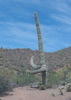
We scrambled through the various boulders and cracks and eventually crossed the bridge and reached the wall, the last big obstacle. With some pack shuttling and creative teamwork, TboneKathy made it up first, and with some further encouragement and some minor complaining through the last few obstacles, we reached summit, goal #1 complete. We had the peak to ourselves, a pleasant surprise given Battleship's popularity. There was no register on top--the pink ammo box that had been up there for years is gone. We ate lunch and enjoyed the views, then took some pictures and started down.

[ youtube video ]

As we reversed through the obstacles on the return, TboneKathy thought she saw a fox or wolf down below on the west side of Battleship, but I never caught more than a glimpse of a tail that looked a lot like a squirrel, so her sighting remains in dispute :). We heard voices and saw two guys down in La Barge Canyon, but other than one person coming down on our way up in the morning, we didn't see anyone on Battleship. The views of La Barge, Peak 2830, Weaver's Needle, Malapais, and the Ridgeline were fantastic as always and better than I remembered.

[ youtube video ]

The hike out was blissfully uneventful with no fractured bones, successfully completing goal #2. Weather-wise, the day was just about perfect, and I was happy to see TboneKathy reach the peak after waiting 8 years. Lots of great memories hiking Battleship with friends over the years, and it was fun to be back after a long time away for another memorable day.
 Fauna
 Fauna [ checklist ]
[ checklist ]  Phainopepla
 Culture
 Culture [ checklist ]
[ checklist ]  Cairn

water 1 out of 5water less than maxwater less than maxwater less than max Boulder Creek at #103 / #236 Jct Pools to trickle Pools to trickle
A few small pools, but mostly dry

dry La Barge Creek - E of Battleship Mtn Dry Dry
Viewed from above, no obvious water in the creek bed, but some pools in La Barge Box
  1 archive
222076
Mar 01 2025
avatar

 Routes 434
 Photos 49
 Triplogs 842

43 female
 Joined Jun 23 2015
 Phoenix, AZ
Boulder Canyon Trail #103Phoenix, AZ
Phoenix, AZ
Hiking avatar Mar 01 2025
emilystardustTriplogs 842
Hiking11.64 Miles 2,327 AEG
Hiking11.64 Miles   6 Hrs   44 Mns   1.92 mph
2,327 ft AEG      40 Mns Break
 
no photosets
Linked   linked  
Partners none no partners
Route Scout Route recorded on Route Scout | Pop | Map | Popup | MapDEX
A few people had never been to La Barge so off we went. But definitely will need to come back when there’s more water.
_____________________
 
221847
Jan 21 2025
avatar

 Routes 93
 Photos 8,310
 Triplogs 1,766

65 male
 Joined Mar 11 2003
 AZ
Second Water Trail #236Phoenix, AZ
Phoenix, AZ
Hiking avatar Jan 21 2025
wallyfrackTriplogs 1,766
Hiking11.50 Miles 2,070 AEG
Hiking11.50 Miles   5 Hrs   39 Mns   2.04 mph
2,070 ft AEG
 no routes
Linked   linked  
Partners none no partners
Saw some information about possible cliff dwellings so off I went. Of course there wasn't anything up there except some fool sliding up and down the slopes but I had to. The morning was breezy and cold in the open. Once out of the wind it was nice. Garden Valley is an interesting walk, with the moonscape you can see the canals and how large of and area it is. Second Water Canyon had a lot of water which was a surprise. You could easily filter in several spots if needed. La Barge Creek is dry but I didn't go all the way to the lower box. I scrambled up the slope to the cliff band and then back along the cliff band and found a way back down. Loose and steep was the challenge for the day. Once back on trail I was so happy the hills on the trail seemed like nothing. Lots of hikers out but it wasn't crowded by any means. A good hike but I won't be going up to those cliffs again.
_____________________
  4 archives
220671
Jan 04 2025
avatar

 Routes 434
 Photos 49
 Triplogs 842

43 female
 Joined Jun 23 2015
 Phoenix, AZ
Boulder Canyon Trail #103Phoenix, AZ
Phoenix, AZ
Hiking avatar Jan 04 2025
emilystardustTriplogs 842
Hiking4.99 Miles 1,178 AEG
Hiking4.99 Miles   2 Hrs   20 Mns   2.19 mph
1,178 ft AEG      3 Mns Break
 
no photosets
Linked   none no linked trail guides
Partners none no partners
presumably took memories and left without a trace...
_____________________
 
220361
Nov 09 2024
avatar

 Guides 1
 Routes 494
 Photos 4,428
 Triplogs 988

68 male
 Joined Mar 09 2012
 Gilbert, AZ
Boulder Canyon Trail #103Phoenix, AZ
Phoenix, AZ
Hiking avatar Nov 09 2024
rayhustonTriplogs 988
Hiking11.67 Miles 2,394 AEG
Hiking11.67 Miles   6 Hrs   17 Mns   2.09 mph
2,394 ft AEG      42 Mns Break
 
Linked   none no linked trail guides
Partners none no partners
Hiked to the saddle on the south end of Battleship Mountain. Back the same way. I was not ready for a day hike. The ascent from La Barge Canyon on the way back killed me. The final 2.5 miles was a painful end to what started out well.
Getting old or out of shape? Sticking with out of shape for now. The weather was sensational. Lots of hikers on the trail.
p.s The Boulder Canyon Trail is free of fire damage up to the intersection with Cavalry Trail.
_____________________
  1 archive
219005
Apr 27 2024
avatar

 Guides 2
 Routes 284
 Photos 10,346
 Triplogs 424

63 male
 Joined Dec 02 2014
 Mesa, AZ
Boulder Canyon Trail #103Phoenix, AZ
Phoenix, AZ
Hiking avatar Apr 27 2024
adillingTriplogs 424
Hiking5.03 Miles 1,195 AEG
Hiking5.03 Miles   3 Hrs   12 Mns   1.79 mph
1,195 ft AEG      23 Mns Break
 
Linked   none no linked trail guides
Partners none no partners
Route Scout Route recorded on Route Scout | Pop | Map | Popup | MapDEX
Taking advantage of a cold front that came in, I wanted to head out and get in a quick hike in the Superstitions. Still being on the mend, I opted for Boulder Canyon from Canyon Lake Marina.

I was hoping for a nice sunrise, but the low clouds on the eastern horizon made me think it would be a dud. But, for a brief moment, the sun did come out and put on a limited color show.

I was a slow mover going up to the first viewpoint, but I did ok. The light was not optimal with the clouds blocking the sun, but it's always stunning views along this one. If this place was in another state, it would be a National Park. I think I prefer the Wilderness designation to keep the masses at bay.

After soaking in the views on the first viewpoint, I headed to the second area above La Barge Creek. There was a trailrunner that passed me while I was heading up and then passed me up again going back. He was really moving. There was another group of 3 hikers that I saw heading down to La Barge Creek. Battleship, perhaps? Other than those fellow earlybirds, I had the entire trail to myself.

After checking out the view and hoping for better light, I decided to head back. It wasn't until I was almost back to the first viewpoint that the dam broke and I saw a steady stream of hikers all the way back down. The parking lot for hikers at the marina was packed and there were quite a few vehicles parked along Hwy 88 as well.

My road to recovery is going well and I felt really good hiking up and back down. I love this trail and along with Peralta Trail, it's my favorite trail in the Supes.
_____________________
"Jobs fill your pockets, adventures fill your soul."

instagram: @andydilling
 
215025
Apr 27 2024
avatar

 Guides 1
 Routes 494
 Photos 4,428
 Triplogs 988

68 male
 Joined Mar 09 2012
 Gilbert, AZ
Boulder Canyon Trail #103Phoenix, AZ
Phoenix, AZ
Hiking avatar Apr 27 2024
rayhustonTriplogs 988
Hiking8.07 Miles 1,908 AEG
Hiking8.07 Miles   4 Hrs   10 Mns   2.12 mph
1,908 ft AEG      22 Mns Break
 
Linked   none no linked trail guides
Partners none no partners
Route Scout Route recorded on Route Scout | Pop | Map | Popup | MapDEX
10am start. Hiked from Canyon Lake to the junction with Second Water trail where I stopped for lunch. I returned the same way. Wildflowers are all but gone. Brittlebush is hanging on, same with globemallow on the canyon floor. I saw a few poppies just before reaching the canyon floor. It will all be gone soon, overtaken by foxtail, which is waiting in the wings. Flowering cacti stole the show today, buckhorn cholla and prickly pear leading the way. I saw my first saguaro flower, too, high up on an arm. There were quite a few people hiking to the overlook and back. I saw two people beyond that point. One was hiking from FW to Canyon Lake and back. He was cruising the second time I saw him, the hard part out of the way. I also saw several people returning from Battleship along the Second Water trail. Beautiful day. I had cloud cover ascending the steep hill out of the canyon, heading back up to the overlook. That was a first. Fun hike, fun day.
wildflower observationwildflower observationwildflower observationwildflower observationwildflower observation
Wildflowers Observation Isolated
Brittlebush, globemallow and a few poppies, all in decline

water 1 out of 5water less than maxwater less than maxwater less than max Boulder Creek at #103 / #236 Jct Pools to trickle Pools to trickle
Maybe leaning closer to a light flow.

water 1 out of 5water less than maxwater less than maxwater less than max La Barge at Boulder Creek Trail #103 Pools to trickle Pools to trickle
Nice pools
_____________________
 
215047
Apr 14 2024
avatar

 Routes 41
 Photos 64
 Triplogs 44

58 male
 Joined Mar 29 2015
 Chandler, AZ
Second water to battleship mnt, AZ 
Second water to battleship mnt, AZ
 
Hiking avatar Apr 14 2024
AndrewrdcTriplogs 44
Hiking10.80 Miles 1,637 AEG
Hiking10.80 Miles   5 Hrs   29 Mns   2.23 mph
1,637 ft AEG      39 Mns Break10 LBS Pack
 
1st trip
Route Scout Route recorded on Route Scout | Pop | Map | Popup | MapDEX
Started from second water trailhead at 7:20am (Sunday)… parking lot about half full. Hiked down to boulder creek and then made a right (East) to end of battleship. Plenty of water flowing in n Boulder creek! Great day hike… not many hikers out today. I always forget how rocky parts of this hike are… boots definitely recommended.

water 1 out of 5water 2 out of 5water 3 out of 5water less than max Boulder Creek at #103 / #236 Jct Medium flow Medium flow
PLENTY of water flowing all the way past Battleship Mnt

water 1 out of 5water 2 out of 5water less than maxwater less than max La Barge Box Light flow Light flow
Very large pool of water at entrance to La Barge box

water 1 out of 5water 2 out of 5water less than maxwater less than max Second Water Canyon Light flow Light flow
Some flow coming down from Spring... very light with some pools of water.
_____________________
  2 archives
214691
Apr 05 2024
avatar

 Routes 286
 Photos 8
 Triplogs 292

54 male
 Joined Feb 19 2015
 Phoenix
Boulder Canyon Trail #103Phoenix, AZ
Phoenix, AZ
Hiking avatar Apr 05 2024
bjonsonTriplogs 292
Hiking8.70 Miles 1,935 AEG
Hiking8.70 Miles   4 Hrs   18 Mns   2.11 mph
1,935 ft AEG      11 Mns Break
 
no photosets
1st trip
Linked   linked  
Partners none no partners
presumably took memories and left without a trace...
Route Scout Route recorded on Route Scout | Pop | Map | Popup | MapDEX
_____________________
 
214466
average hiking speed 2.04 mph
1, 2, 3, 4, 5 ... 26  Next

WARNING! Hiking and outdoor related sports can be dangerous. Be responsible and prepare for the trip. Study the area you are entering and plan accordingly. Dress for the current and unexpected weather changes. Take plenty of water. Never go alone. Make an itinerary with your plan(s), route(s), destination(s) and expected return time. Give your itinerary to trusted family and/or friends.

helpcommentissue

end of page marker