username
X
password
register
for free!
help
ArticlesGuidesRoutes
 
Photosets
 
 Comments
triplogs   photosets   labels comments more
Lime Creek - 6 members in 16 triplogs have rated this an average 4.2 ( 1 to 5 best )
16 triplogs
login for filter options
Feb 01 2025
avatar

 Guides 94
 Routes 840
 Photos 22,055
 Triplogs 1,993

52 male
 Joined Sep 18 2002
 Tempe, AZ
Sunset Mountain 4598Phoenix, AZ
Phoenix, AZ
Hiking avatar Feb 01 2025
chumleyTriplogs 1,993
Hiking13.15 Miles 3,315 AEG
Hiking13.15 Miles   9 Hrs   57 Mns   1.56 mph
3,315 ft AEG   1 Hour   32 Mns Break
 
1st trip
Partners partners
BobP
Dave1
Route Scout Route Recorded  on Route Scout | Pop | Map | Popup | MapDEX
Bob wanted to do a 4 Peaks Circumference hike today, but that seemed like a terrible sufferfest, so we ended up on this less-terrible sufferfest instead. :)

The plan was to drive to the start via FR1530, but I left my Medal driving skillz at home and despite my numerous doubtful queries about traversing the slope along the edge of the lake, Bob had done this before and insisted that it was easy. Apparently that word has a different meaning for some people. This part took 45 min, which is as long as walking the road would have taken, but I'd argue the lakeside route was more scenic and interesting. Obviously, lake level plays a factor here in these choices.

Bob's memory was a little better in leading us up a very cool limestone canyon before gaining the ridge that ascends directly up to 3531. This is a near-vertical climb covered with those neat little granite ball bearings and dotted with all the traditional prickly desert obstacles. Luckily there was an occasional piece of bedrock to plant your foot on, but only briefly, as your weight will dislodge it and send it careening toward your hiking partners below. I shed some blood after a tumble on one of those firmly anchored 500-lb boulders that was apparently not firmly anchored. It's 1000 feet in half a mile and took us about an hour.

On the map, 3531 is a short and relatively flat ridgeline traverse from Lime Peak. In reality, it was the most enjoyable boulder hopping on the day, with some knife-ridge spots and a lot of short ups, downs, and arounds. Fun, but not fast -- half an hour to get over to the Lime summit. Requisite benchmarks and break before heading down to the frustum marking the county boundary. Bob misunderpronounces that word, and I prefer his version better.

Next, we skirted a small hill along the ridge, and this turned out to be a bad plan. The extra elevation staying true to the ridge would have avoided some pretty thick, prickly, slippery, side-slope traverse. Going over the top is a 200 foot climb, and worth it.

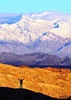
The steepest part of the climb to Sunset gains 600 feet in 0.3mi. It looked worse from a distance than it did underfoot, but as with the approach to Lime, this was slow going. It took a bit over an hour to climb the 1000 feet from the saddle to the Sunset summit. The views along the way were spectacular and made for nice breathing breaks. There were a good number of historic structures at several points along the ridge, and the summit was once a mountaintop fortress. Worth a visit if that's your thing.

We decided that descending the steep ball-bearings didn't sound fun, and John10s had reported some unpleasant brushy sections on the eastern slopes, so we plotted a route down via a more moderate looking ridge off the west slope and down into Lime Creek, after I assured Bob and Dave that there was an ADA-compliant trail along the creek. :?

This turned out to be a great decision, and though there was some prickly-pear pinball coming off peak 3724, the grade was nice, the views were great, and ample cattle and wildlife paths provided comfortable travel the whole route down. Upon reaching the creek, I was pleased to see it was flowing, something I didn't think was possible in here winter 24-25. Looking at the map, we were a bit disheartened to see just how far upstream we had ended up, but figured we would still make it back by dark.

Though I promised that the creek would soon disappear underground, it never did. It lead us through a really nice stretch of narrows that required unplanned wading, and otherwise meandered through a beautiful desert canyon for four miles before reaching the end of the road where we began the ascent. I only slipped on the rocks and submerged once! Later I almost stepped on a skunk that was napping in the grass. Thankfully he decided to waddle away without blasting a warning shot my way. Not long after a curious gray fox watched as we passed from a sheltered spot in the cliffs. Along with some deer, not a bad day for wildlife sightings.

I offered to take the lake route back to the truck and let Bob and Dave walk the road where I would pick them up, but we all opted for lakeside misery and scenery once again.

This was a long, difficult, tiring day, but had a whole bunch of rewards that made it very enjoyable.
 Fauna
 Fauna [ checklist ]
[ checklist ]  Skunk
_____________________
I'm not sure what my spirit animal is, but I'm confident it has rabies.
 
Feb 01 2025
avatar

 Guides 2
 Routes 251
 Photos 4,593
 Triplogs 3,212

63 male
 Joined Feb 26 2008
 Scottsdale, AZ
Sunset Mountain 4598Phoenix, AZ
Phoenix, AZ
Hiking avatar Feb 01 2025
BobPTriplogs 3,212
Hiking13.15 Miles 3,315 AEG
Hiking13.15 Miles
3,315 ft AEG
 no routes
1st trip
Partners partners
chumley
Dave1
It had been about 8 years since I hiked with SuperDave. Funny we were going to meet Chums but we almost went off the road twice and had another truck almost slide into us. So we ended up with an awesome plan B of Cheops Pyramid instead of a dico party at the beach. As I write this, its been more then a day to reflect on the good,and the bad of this hike. Mostly good until I pulled a muscle. Thanks Chums for the ace bandage. I can't believe its Feb and I've hiked with Chums 3 times already. He was my first hiking partner on HAZ back almost 16 years ago :).

The shoreline was different from 2 years ago because there was less water then this years heavy rainfall. I'm glad I missed some of the shoreline when I headed up a drainage to the road. I rejoined the guys shortly after. The hike to Lime was uneventfull. The ridge was as fun as I remembered. My first frustum in many years, but you always remember your first which was in the Mazzies. The hike up to Sunset was eventfull. I had several cactus puncture my soles which sucked. My muscle pull gradually bothered me to the point where it needed attention but no massage therapist was present. Dave said I was just looking for attention after he sat on a cactus. The ridge down was relatively good except for my mood. We took a break at the creek and headed down. I headed up and found a great track looking down on the narrows. I downclimbed to about 50 feet and had to head back up and eventually found a safe route down. I kept dry for awhile then it wasnt worth the effort. All in all a great day. The good was way better than the bad. Thanks chums for driving. Dave good to hike with you again after a long time.
_____________________
https://www.seeitourway.org
Always pronounce Egeszsegedre properly......
If you like this triplog you must be a friend of BrunoP
 
Jan 04 2025
avatar

 Photos 83
 Triplogs 5

65 male
 Joined Nov 20 2005
 Chandler, AZ
Lime CreekPhoenix, AZ
Phoenix, AZ
Hiking avatar Jan 04 2025
scout22Triplogs 5
Hiking7.00 Miles 550 AEG
Hiking7.00 Miles
550 ft AEG
 no routes
1st trip
Linked   none no linked trail guides
Partners none no partners
First time hiking in Lime Creek area, really enjoyed the geography and managed to hike far enough up creek to find the flowing water, much to the excitement of my water loving dog!
 Fauna
 Fauna [ checklist ]
[ checklist ]  Dog
_____________________
 
Dec 16 2022
avatar

 Guides 47
 Routes 96
 Photos 850
 Triplogs 385

81 male
 Joined Dec 24 2005
 Phoenix, AZ
Lime CreekPhoenix, AZ
Phoenix, AZ
Canyoneering avatar Dec 16 2022
MEWhitemanTriplogs 385
Canyoneering7.10 Miles 882 AEG
Canyoneering7.10 Miles   4 Hrs      1.78 mph
882 ft AEG
 no routesno photosets
1st trip
Linked   none no linked trail guides
Partners none no partners
We followed Oregon_Hiker's track up to the dam and back. What a nice area. When we "eyeballed" the creek from the Lime Creek Cabin trail, Tom said it would be a flat walk along the creek from Horseshoe Lake. So we thought we'd give it a try. It was pretty flat along the creek, but more than half the distance was on the road which was impassable for anything other than a serious off-road vehicle. The road walk part accounted for most of the AEG.
_____________________
  2 archives
Dec 12 2021
avatar

 Guides 12
 Routes 192
 Photos 863
 Triplogs 356

42 male
 Joined Nov 30 2015
 Phoenix, AZ
Lime CreekPhoenix, AZ
Phoenix, AZ
Canyoneering avatar Dec 12 2021
ShatteredArmTriplogs 356
Canyoneering14.57 Miles 1,101 AEG
Canyoneering14.57 Miles   5 Hrs   31 Mns   2.65 mph
1,101 ft AEG      1 Min Break
 
1st trip
Linked   none no linked trail guides
Partners none no partners
Wanted something on the chill side (i.e. not runnable) this weekend, so I decided it would be fun to check out the lower part of Lime Creek from Horseshoe Lake. Got to the start around 11am, drove a little ways down the Jeep road, but found some tippy spots and decided to pull off and walk the last mile. I think the Wrangler could've made it all the way to Lime Creek, but the goal wasn't to test my driving skills, so...

Creek flow started right where the road hit the creek, and flowed the entire rest of the way. Didn't do a whole lot of research, but I was expecting stretches to have water, not the whole thing... Easy going at first, then it starts getting a little more boxed in, and from that point on it was fastest and most pleasant to generally just walk in the creek. No serious obstacles at all. There are (were?) trails that parallel the creek for some stretches, but it didn't seem worth it at all to worry about them.

The highlight was a nice narrow, slot-like section about 5 miles in. I think there is a trail that bypasses this stretch, but why would you skip the best part of the whole creek? I was worried there could be a swimmer, but it never got more than knee deep, and there were just a couple of light scrambles.

Once up past the narrows, everything was trampled by the cattle. Originally thought we might be able to make the cabin, but we were at 2 hrs 45 minutes when we got to where the trail drops in, so turned around there. This was a fun one.

water 1 out of 5water 2 out of 5water 3 out of 5water less than max Lime Creek Medium flow Medium flow
Solid flow from about a mile upstream from the lake, all the way to the Lime Creek Cabin trail. Would avoid drinking because of the cattle.
_____________________
 
Mar 21 2020
avatar

 Routes 189
 Photos 7,236
 Triplogs 1,740

57 male
 Joined Apr 25 2011
 Goodyear, AZ
Lime CreekPhoenix, AZ
Phoenix, AZ
Canyoneering avatar Mar 21 2020
NightstalkerTriplogs 1,740
Canyoneering3.30 Miles 482 AEG
Canyoneering3.30 Miles   1 Hour   38 Mns   2.61 mph
482 ft AEG      22 Mns Break13 LBS Pack
 no routes
1st trip
Linked   none no linked trail guides
Partners partners
Gallydoll
Drove out to Horseshoe Dam to see the water release. Hiked up the road to Lime Creek to the high point. Was planning to make a loop out of it, but my planned return route is currently 20' under water. The road to Lime Creek is serious high clearance and narrow at spots. Great views of Horseshoe Lake from the high spot.
wildflower observationwildflower observationwildflower observationwildflower observationwildflower observation
Wildflowers Observation Extreme
_____________________
 
Nov 22 2018
avatar

 Guides 4
 Photos 2,750
 Triplogs 402

60 male
 Joined Nov 13 2005
 Cave Creek, AZ
Lime CreekPhoenix, AZ
Phoenix, AZ
Canyoneering avatar Nov 22 2018
cabelTriplogs 402
Canyoneering6.00 Miles 550 AEG
Canyoneering6.00 Miles
550 ft AEG
 no routesno photosets
1st trip
Linked   none no linked trail guides
Partners none no partners
Great way to spend thanksgiving before eating. Got off trail and found plenty of petroglyphs.
_____________________
All who wander are not lost...just me.
 
Dec 07 2014
avatar

 Guides 9
 Routes 473
 Photos 8,433
 Triplogs 626

79 male
 Joined Dec 07 2010
 Phoenix, AZ
Lower Lime Creek Trail, AZ 
Lower Lime Creek Trail, AZ
 
Hiking avatar Dec 07 2014
Oregon_HikerTriplogs 626
Hiking7.60 Miles 797 AEG
Hiking7.60 Miles   6 Hrs   38 Mns   1.15 mph
797 ft AEG15 LBS Pack
 
1st trip
Linked   linked  
Partners none no partners
My goal for this hike was to confirm the location of an old pack trail that follows Lime Creek up the canyon from the Verde River (Horseshoe Reservoir). Entries in the Lime Creek Cabin visitor log indicated that people on horseback had followed this trail to the cabin from Horseshoe Reservoir. I suspect this old pack trail may have been established for mining access to the upper canyon where a small smelter is located or it may have been an old ranching trail. I had seen evidence of this trail along the sides of the creek on a hike in Feb. 2014 to the fish dam and also on Google Earth.

I started the hike early to give some time for exploring and arrived at the Horseshoe Reservoir overlook as the rising sun was starting to light up the mountains on the west side of the reservoir. The early light gave a reddish glow to the mountain tops and wisps of fog were rising from the Verde River. I spotted three water fowl hunters who had waded across the river near the boat ramp and were stealthily working their way across the lake bottom to the pond sized impoundment behind the dam. I drove down the 4WD trail that went from the top of the boat ramp to the high-water shoreline and then up the dry creek bed until I reached a point where I decided it was better to start hiking than risk serious injury to the bottom side of the FJ. This ended up shortening the round trip hiking distance by 3.8 miles from the closest point accessible by lower clearance vehicles.

The hike started out following the stream bed with the usual rock hopping but no bouldering. The stream was flowing for the entire length of this lower section of the canyon except for about the first half mile of the hike where it had been absorbed into the sandy creek bottom. No deep wading was required and I was able to keep my feet dry with my mid-height gortex boots left over from living in Oregon. There is no visible trail along the creek bottom but short sections can be spotted by keeping an eye on the shore in areas where the bank is wide. Some of these trails are marked by faded ribbons in the trees or by rock cairns. I had also been able to see some of the trail creek-bottom bypasses on Google Earth and had a planning track for these on my GPS. The trail sections had been excavated out of the hillside with considerable effort in some places. This leads me to think its original use was as a mining pack trail. At about mile 3 on my gps track the trail leaves the canyon bottom to avoid a slot section of the canyon and stays up on the hillside well past the smelter location. It may be possible to continue up the creek bottom through the slot but the trail is a much quicker and easier route. I turned around when I reached a trail section where I had been on a previous trip going down canyon from the Lime Creek Cabin [ triplog ] .
 Culture
 Culture [ checklist ]
[ checklist ]  Mining Equipment
 Meteorology
 Meteorology [ checklist ]
[ checklist ]  Moon  Sunrise
_____________________
  1 archive
Dec 06 2014
avatar

 Guides 41
 Routes 1,626
 Photos 14,983
 Triplogs 2,760

69 male
 Joined Jan 20 2009
 Far NE Phoenix,
Lime Creek - Professor Creek, AZ 
Lime Creek - Professor Creek, AZ
 
Hiking avatar Dec 06 2014
The_EagleTriplogs 2,760
Hiking14.84 Miles 3,387 AEG
Hiking14.84 Miles   7 Hrs   34 Mns   2.37 mph
3,387 ft AEG   1 Hour   19 Mns Break16 LBS Pack
 
1st trip
Partners partners
chumley
John9L
Tough_Boots
A trip out to Lime Creek to visit some new areas. We had all sorts of options drawn up, to please a wide group of hikers. The Cabin for those that had not been there, numerous piles of rocks were waypointed (Thanks Oregonhiker), riparian areas, new canyons to explore, and peaks to bag.

On the way to the cabin we hit 3 Piles of Rocks, two of which I'd walked right past the first time to Lime Creek. There was a bit-o-color hanging on in spots in Lime Creek, but 2 weeks past prime for sure.

We dropped Kyle an Lilly off at the cabin to relax and went to Professor Canyon to do some 'splorin'. Some very sweet looking areas here, but we only went as far as the lush riparian area of Professor Spring. I'd like to take this to the top on a future trip.

On the way back to the Cabin to pick up Kyle and Lilly, the others started barking to get Lilly excited. We were shocked when around the corner came a dog that wasn't Lilly. It was one of about 8 dogs that two Lion Hunters were running. The dogs were all equipped with GPS collars and "reminder" collars (Which I got to see in action).

Lime Spring area and Cabin :next: https://www.youtube.com/watch?v=ChNj29SzTqc

We stopped back at the Cabin and had a nice conversation with these two Cowboys.

After this it was the Slog back up the hill to the truck.

We took the short drive up to Humboldt to check out the scenery. Well worth the drive if you are in the area. Thanks for driving Chums... a fun day

Views atop Humboldt :next: https://www.youtube.com/watch?v=fZuYb3Oor50
 Fauna
 Fauna [ checklist ]
[ checklist ]  Dog
foliage observationfoliage observationfoliage observationfoliage observationfoliage observation
Autumn Foliage Observation Isolated
Still hanging on in spots, but probably 2 weeks past prime.

water 1 out of 5water less than maxwater less than maxwater less than max Lime Creek Pools to trickle Pools to trickle
Plenty of spots to filter water from the Lime Creek trail, to the Lime Cabin

water 1 out of 5water 2 out of 5water 3 out of 5water less than max Lime Spring Gallon per minute Gallon per minute
We did not o to the source, but it was flowing nicely to Lime creek

water 1 out of 5water less than maxwater less than maxwater less than max Professor Creek Pools to trickle Pools to trickle
It went underground in most spots, but pools were plentiful near the spring areas.

water 1 out of 5water 2 out of 5water less than maxwater less than max Professor Spring Quart per minute Quart per minute
Plenty of filterable water

dry Walnut Spring Dry Dry
Never seen water in this area. Water in the creek bed was probably from recent rains.
_____________________
There is a very fine line between "hobby" and "mental illness."
Dave Barry 🦅
  1 archive
Feb 13 2014
avatar

 Guides 9
 Routes 473
 Photos 8,433
 Triplogs 626

79 male
 Joined Dec 07 2010
 Phoenix, AZ
Lime CreekPhoenix, AZ
Phoenix, AZ
Hiking avatar Feb 13 2014
Oregon_HikerTriplogs 626
Hiking7.50 Miles 890 AEG
Hiking7.50 Miles
890 ft AEG
 
Linked   none no linked trail guides
Partners none no partners
My plan was to drive out to the mouth of Lime Creek Canyon where it dumps in to the Verde River and Horseshoe Reservoir. I was hoping to find the lower end of the old horse pack trail that goes all the way up Lime Creek Canyon from the Verde River to the Lime Creek Cabin and hike up this trail for a few miles. I had been on the upper portion of this trail during a backpacking trip in January, http://hikearizona.com/photoset=28527. That section of the trail appeared to have a lot of recent use and even some trail maintenance.

Horseshoe Reservoir had quite a bit of water in it, enough to make the cement launch ramp useable. I half expected to see the SS Aviator plying the lake but there were no water craft to be seen.

The 4x4 spur road to Lime Creek is definitely a high clearance 4x4 road. I chickened out at a washed out section - would have tried it if I had someone with me to act as a spotter to guide me through. So I hiked the remainder of the road to the canyon and down to Lime creek. This added about 3 miles round trip to the hike. I had expected to see the old pack trail taking off from this road somewhere along the hillside on the southwest side of the creek. Not seeing anything resembling the well traveled trail I had seen further up the canyon I proceeded on to the creek and started following it up-canyon.

The creek was dry where the 4x4 road descended to the canyon bottom but a trickle of water appeared a few hundred yards up canyon. This trickle turned into a small flowing stream further up the canyon. Once past the end of the ATV track there was no sign of an established trail. It was fairly easy going up the rocky bottom of the canyon with an absence of thorn bushes. :y: Not long after leaving the ATV track behind I noticed an orange ribbon hanging from a tree on the creek bank. Checking it out I found a trail with horse hoof prints paralleling the creek and bypassing a section that would have been tough going for someone on horseback. It ended a short distance later after returning to the creek bed. These marked bypass trails continued in a couple more places bypassing difficult sections of creek bed. This made for an easier hike all the way to the fish barrier dam but I wasn't sure if this was the trail that went all the way to the upper canyon. I got to the fish dam at my turn around time without even getting my feet wet. I didn't have time to look for a bypass trail around the dam but it looked like this was probably the end of the "horse trail" going up the creek bottom. So I headed back to the car disappointed that I hadn't found the trail I was looking for. But the tranquility of a flowing stream in this desert canyon made the effort worthwhile.

That evening at home I used Google Earth to search for more horse bypass trails along the canyon bottom at the fish barrier dam and further up-canyon. To my surprise, a trail could be seen bypassing the dam on the northeast bank that I had not seen on the hike. There were also several more sections of bypass trail visible further up the creek bottom and one finally leading up the west side and starting a traverse along this hillside that I assume would connect with the trail I had seen in the upper canyon. So, it appears that this old (and still used) pack trail followed the creek bottom in the lower part of the canyon to a point well past the dam. One of the bypass sections I found on the hike was on an excavated trail/road bed cut into the steep hillside. I suspect this pack trail had been established long ago to supply the mining operation at the old smelter located about 4 miles up canyon from the Verde River.
_____________________
 
Jan 20 2014
avatar

 Guides 9
 Routes 473
 Photos 8,433
 Triplogs 626

79 male
 Joined Dec 07 2010
 Phoenix, AZ
Lime CreekPhoenix, AZ
Phoenix, AZ
Backpack avatar Jan 20 2014
Oregon_HikerTriplogs 626
Backpack19.10 Miles 3,528 AEG
Backpack19.10 Miles3 Days   4 Hrs   15 Mns   
3,528 ft AEG44 LBS Pack
 
Linked   linked  
Partners none no partners
This was a 4 day (3 nights) backpack trip into Lime Creek Canyon to explore the canyon from the Lime Creek Cabin down stream as far as time and interest would take me. That ended up being only a 3 mile stretch of canyon because of my leisurely pace and the many side trips to look for Indian ruins. On the descent into the canyon there are great views all the way to its mouth at Horseshoe Reservoir (which actually has water in it now)and beyond to the Mazatzals. Sunset Mountain dominates the view on the east side of the canyon. I wondered if anyone on HAZ bagged that peak but I could find no record of it in a quick site search. The first night I camped at the cabin site and then moved my camp down canyon 1.8 miles to a spot near the creek. I stayed at this campsite for the next two nights exploring the surrounding area on both sides of the creek over the next mile downstream. Over three days I found 6 small Indian ruin sites and pottery sherds in a few areas with no ruins. This canyon with its perennial flowing creek must have been a popular place with the ancients.

At 3.4 miles from the trailhead on the way to the cabin I came across a sign at a fork in the trail. I haven't seen any mention of this sign in previous LC Cabin triplogs so wonder if it is new. The sign indicated that it was 1 mile to an old smelter and 5 miles to the Verde River on the trail fork which headed down canyon. Entries in the cabin log book indicated several guests had arrived on horseback by that trail. I used this trail in my explorations down canyon over the last two days but never got much further than the old smelter. The first 0.3 miles of this trail led from the sign down to the creek where it crossed and proceeded down the east side for about a half mile before crossing back to the west side. The first 0.3 miles had recent maintenance where rocks had been removed and sometimes dug out of the trail and placed in a line outlining both sides of the trail. After the creek crossing the trail showed no recent maintenance and was faint in areas marked by the occasional orange faded to white marker tape. Both the cabin trail and the trail to the Verde showed signs of fairly heavy use with lots of recent human foot prints and older horse shod hoof prints.

I could not find any signs of mining despite the presence of the smelter. The only evidence of cattle ranching I found in the canyon were the upper corrals at the cabin which had a chute with cow squeeze for holding the critters during branding and vaccinating. However there was no evidence of current use for cattle, i.e. no cow pies. The lower corrals by the cabin are obviously being used for horses as a horse riding group from Glendale visits frequently and does upkeep on the cabin and water supply line from the spring.

It was a long 1900 elev ft slog back up out of the canyon on the last day. Even with a pack lightened by no food and only carrying 1.5 liters of water (I had cached water on the way in) my shoulders and back were beginning to ache. Adjusting the heavy items in the pack closer to my back fixed that problem but it was still slow going. Maybe I'm getting too old for backpacking but the rewards of solitude in a beautiful place will get me out there again.
 Flora
 Flora [ checklist ]
[ checklist ]  Sugar Sumac
 Culture
 Culture [ checklist ]
[ checklist ]  Camp-fire  HAZ Rides
 Named place
 Named place [ checklist ]
[ checklist ]  Sunset Mountain
_____________________
 
Dec 19 2012
avatar

 Guides 1
 Routes 9
 Photos 1,560
 Triplogs 45

36 male
 Joined Nov 06 2010
 Phoenix, AZ
Lime CreekPhoenix, AZ
Phoenix, AZ
Canyoneering avatar Dec 19 2012
ASUAviatorTriplogs 45
Canyoneering6.00 Miles 550 AEG
Canyoneering6.00 Miles   5 Hrs      1.29 mph
550 ft AEG      20 Mns Break
Canyon Hiking - Non-technical; no rope; easy scrambling; occasional hand use
A - Dry or little water; shallow or avoidable water; no wet/dry suit
II - Normally requires a half day
 no routes
Linked   none no linked trail guides
Partners none no partners
Had the day off and had to get out. opted for Lime Creek due to its close remoteness. Turned out to be a great choice. The rains have it flowing well, and it was cool to see water flowing in from the tributary canyons as well. Making way up the canyon, there were some fresh lion prints on a sandbar! Man I hope to see one soon. There was alot of deer and javelina track throughout as well. The rain the night before made for a nice clean slate and stories were written all over it. Made it to the fish barrier damn and found a tarantula chilled out on top of it. I moved him into some sunlight to give him a fighting chance. Others werent so lucky. came across the head of a fox and carcass of a Gila monster. Im now a pretty big fan of the canyon for the many reasons listed above.

FYI. Horseshoe dam rd and the trail leading to lime creek arent in the best of shape. 4x4 is definately required on the trail in.

Kyle-
 Culture
 Culture [ checklist ]
[ checklist ]  Aircraft

water 1 out of 5water 2 out of 5water 3 out of 5water less than max Lime Creek Medium flow Medium flow
Medium flow for what I would expect it to be. Im sure the recent rains have helped greatly
_____________________
  1 archive
Apr 01 2012
avatar

 Guides 1
 Routes 9
 Photos 1,560
 Triplogs 45

36 male
 Joined Nov 06 2010
 Phoenix, AZ
Lime CreekPhoenix, AZ
Phoenix, AZ
Canyoneering avatar Apr 01 2012
ASUAviatorTriplogs 45
Canyoneering2.00 Miles 550 AEG
Canyoneering2.00 Miles   3 Hrs      0.67 mph
550 ft AEG
 no routes
Linked   none no linked trail guides
Partners none no partners
This is a canyon I would like to make a hike up in the near future. I Headed out the Horseshoe to check out the area and lake. I brought Molly so she could have some fun swimming and sniffing around. Ran across the posted Gila and took a few minutes to enjoy the find. He had some length but was skinny where he shoulda been fat. We parted ways friends :D Saw 2 Bald Eagles soaring over the body of lake as well. I help a Tonto forest ranger pick up a full garbage bags worth of trash from a camp site on the lake. People make me sick. Hopin to make the hike up the creek in the next couple weeks.
 Fauna
 Fauna [ checklist ]
[ checklist ]  Dog  Gila Monster
_____________________
 
Jan 09 2011
avatar

 Routes 36
 Photos 2,658
 Triplogs 1,347

67 male
 Joined Jul 28 2004
 Scottsdale, AZ
Lime CreekPhoenix, AZ
Phoenix, AZ
Hiking avatar Jan 09 2011
mazatzalTriplogs 1,347
Hiking6.00 Miles 550 AEG
Hiking6.00 Miles   4 Hrs      1.50 mph
550 ft AEG
 no routes
Linked   none no linked trail guides
Partners none no partners
A bobcat ran across Horseshoe Dam road in front of us during the drive in!

Nice hike up Lime Creek to the new dam. At one point there is an old track that leaves the creek and goes up over a ridge and back to the creek so there must have been an old route up here.
_____________________
 
Oct 14 2010
avatar

 Guides 20
 Routes 12
 Photos 2,343
 Triplogs 298

51 male
 Joined Mar 31 2008
 Gilbert, AZ
Lime CreekPhoenix, AZ
Phoenix, AZ
4x4 Trip avatar Oct 14 2010
ssk44Triplogs 298
4x4 Trip
4x4 Trip
 no routes
1st trip
Linked   none no linked trail guides
Partners none no partners
FYI...


SRP announces remote native fish barrier project on the Tonto National Forest begins Monday


Date: Oct 14, 2010
Contact(s): Jeffrey P. Lane, SRP (602) 236-2500


At a very remote location about two miles upstream of Horseshoe Lake, a construction project that will be interesting for no other reason than its unique logistics will begin next week on a concrete fish barrier in Lime Creek, a small tributary of the Verde River located about 60 miles northeast of Phoenix.

Scheduled to start construction on Monday, the Lime Creek project is designed to prevent nonnative fish in Horseshoe Lake and the Verde River from moving upstream and preying upon and competing with native fishes. The project will ultimately protect about four miles of stream that provides habitat for the native lowland leopard frog and two existing native fish species, the longfin dace and the endangered Gila topminnow, all of which are threatened by nonnative fishes moving upstream from the reservoir.

The fish barrier is a mitigation obligation under Salt River Project's Horseshoe-Bartlett Reservoirs Endangered Species Act permit and Habitat Conservation Plan, developed in partnership with the City of Phoenix and in coordination with the U.S. Fish and Wildlife Service, the Arizona Game and Fish Department and other stakeholders. The project offsets impacts caused from operation of the reservoirs on endangered aquatic species in the Verde River watershed. SRP was issued a Special Use Permit in August by the U.S. Forest Service (USFS) to construct, monitor and maintain the concrete fish barrier.

Although the barrier will be relatively small - 5 feet tall and 20 feet long - it will be a challenging project, according to project manager Chuck Paradzick, an SRP senior environmental scientist.

"We partnered with the U.S. Bureau of Reclamation Engineering Division, which has extensive experience with similar fish barriers, for the design and to select the best location," said Paradzick. "To get it built, an SRP helicopter will be required to long-line the materials into the remote site while the project's contractor, NAC Construction, will need to camp near the creek and hike about a mile and a half to the site daily." NAC Construction also built the Fossil Creek fish barrier for the Bureau of Reclamation, he said.

Paradzick has been working with the U.S. Forest Service and Arizona Game and Fish prior to the start of next week's construction to capture and temporarily move the native fish from the work site. SRP and the Forest Service on Monday will relocate the fish and set block nets to prevent fish from entering the work area, according to the construction schedule, as NAC Construction is mobilizing equipment and supplies at SRP's Horseshoe field house and setting up camp near the creek.

After the equipment is delivered to the site by helicopter Tuesday, Paradzick said a temporary diversion dam will be built, forms will be constructed and the concrete will be delivered and poured over the next few days, weather permitting. The dam will be maintained as the concrete cures, and the site will be cleaned up as scheduled from Oct. 25-27. Once completed, SRP will work with the resource agencies to monitor the barrier and the native fish and frog populations upstream of the barrier.
Lime Creek is a small stream with perennial flow in the upper portions - upstream of the fish barrier - and intermittent flow in the lower reaches - near Horseshoe Lake, one of two lakes on the Verde River. The project area is located on the Cave Creek Ranger District of the Tonto National Forest.

The Lime Creek project was listed as a proposal on the Tonto National Forest Schedule of Proposed Actions in May 2009. The public involvement included a scoping period from May-June 2009 and a public comment period in March-April 2010 during the development of the Environmental Assessment for the issuance of the Special Use Permit.

SRP is the largest provider of water and power to the greater Phoenix metropolitan area, delivering about 1 million acre-feet to agricultural, urban and municipal water users and providing electric service to more than 940,000 customers.


:GB:
_____________________
MATTHEW 11:28-30 / PSALM 84:1-2
 
Nov 24 2007
avatar

 Routes 36
 Photos 2,658
 Triplogs 1,347

67 male
 Joined Jul 28 2004
 Scottsdale, AZ
Lime CreekPhoenix, AZ
Phoenix, AZ
Hiking avatar Nov 24 2007
mazatzalTriplogs 1,347
Hiking5.50 Miles 550 AEG
Hiking5.50 Miles   3 Hrs   20 Mns   1.65 mph
550 ft AEG
 no routes
Linked   none no linked trail guides
Partners none no partners
Nice hike up the creek.
_____________________
 
average hiking speed 1.72 mph

WARNING! Hiking and outdoor related sports can be dangerous. Be responsible and prepare for the trip. Study the area you are entering and plan accordingly. Dress for the current and unexpected weather changes. Take plenty of water. Never go alone. Make an itinerary with your plan(s), route(s), destination(s) and expected return time. Give your itinerary to trusted family and/or friends.

helpcommentissue

end of page marker