username
X
password
register
for free!
help
ArticlesGuidesRoutes
 
Photosets
 
 Comments
triplogs   photosets   labels comments more
Superstition Mountain 4175 Spur - 2 members in 6 triplogs have rated this an average 3.5 ( 1 to 5 best )
6 triplogs
login for filter options
Jul 12 2023
avatar

 Guides 59
 Routes 1,100
 Photos 1,191
 Triplogs 1,290

male
 Joined Jan 01 2023
 Arizona
Superstition Mountain 4175 SpurPhoenix, AZ
Phoenix, AZ
Hiking avatar Jul 12 2023
pseudalpineTriplogs 1,290
Hiking6.26 Miles 2,367 AEG
Hiking6.26 Miles   3 Hrs   16 Mns   2.11 mph
2,367 ft AEG      18 Mns Break
 
1st trip
Route Scout Route Recorded  on Route Scout | Pop | Map | Popup | MapDEX
Tackled this one from First Water Road because of an earlier start possible, instead of waiting on Lost Dutchman Park to open. I've recently scoped the McKellips TH, but it seemed sketchy. When I left, it was 95 in Tempe, but 84 in AJ, so it didn't seem that bad. They're building a new informational sign at the first parking area where the crosscut for Jacob's Crosscut begins. On the traverse over, there were these weird birds (single white spot on each wing) chirping and lurch flying very low all around me and the dry bushes and grass were already active with lizards. The trail was empty on the ascent up Siphon Draw, in fact, I didn't see anyone else on this hike. After leaving Siphon Draw, I thought the gully ascent was quite tame by Supes bushwhack standards. You could tell a great many hikers have crashed through here, perhaps misguided Flatiron hikers. There were a few areas that could use a slight prune. The temperature at the summit of 4175 was breezy nice, plus by then a good cloud cover had established. The original goal was to just return the same route, but after downing some early liquid courage, the northern descent began to strongly draw. I peered over the edge and thought of Ms. Hogan's recent quote in AzHighways, "Oh, it goes". :) I knew the Motherlode route was directly below, so all that had to be done was get to it and the rest would be easy-peasy. I hadn't worn my gaiters to the summit, but now put them on and dropped in. You basically descend directly north from Peak 4175. The dry grasses are very slippery, almost slicker than when they're green and wet. There are a few steep shelves to downclimb here and there and were a few cairns, but for the most part, one can descend and link into the Motherlode route, then the Treasure Loop to Praying Hands route back to Jacob's Trail. There were three deer on the last section of the crosscut. I headed over to finish off Silly Mountain afterwards since I was in the neighborhood.
 Fauna
 Fauna [ checklist ]
[ checklist ]  Mule Deer
  8 archives
Apr 21 2019
avatar

 Routes 7
 Photos 1,242
 Triplogs 61

57 female
 Joined Nov 21 2015
 Phoenix
Superstition Mountain - Near Peak 4175, AZ 
Superstition Mountain - Near Peak 4175, AZ
 
Hiking avatar Apr 21 2019
PicklesTriplogs 61
Hiking
Hiking
 no routes
1st trip
Partners none no partners
The hiking destination was to be Peak 4175 and Peak 4102. One must venture up a ravine to the left of the much traveled path up to Flat Iron at the top of Syphon Draw. Initially, the route is pretty simple to follow and there are a few cairns in the much overgrown ravine that needs to be navigated. I made it about half way up and could clearly see the trek was going to be a bit more challenging than anticipated but I was prepared for it and didn't mind that part of it. However, little creatures that sting mercilessly and like to instill fear in anyone who might be in their vicinity will always turn me back on a hike quicker than anything! I came to a certain choke area I really needed to go through but an area that was really really guarded and inhabited by enough bees to cause me great pain! This would be the end of my pursuit of 4175 and 4102 for the day. I WILL RETURN TO COMPLETE THE TASK!
I refused to call it a day on the whole hike though. I made my way back down Syphon Draw but ventured off trail and climbed up a very steep hillside and into another ravine to see what I could see! Found a lot of bighorn droppings, coyote poo and a mass amount of feathers from some unfortunate winged creature who apparently met an unpleasant demise. What I also picked up on are other areas all around that mountain just begging to be explored. The climb to these areas will certainly be steep but do-able. The hoodoos back in those places would be fascinating up close and personal.
Turned out to be quite the nice solo hike!
_____________________
 
Mar 26 2017
avatar

 Guides 6
 Routes 23
 Photos 1,125
 Triplogs 593

46 male
 Joined May 23 2012
 Mesa, AZ
Peak 4102 - SuperstitionsPhoenix, AZ
Phoenix, AZ
Hiking avatar Mar 26 2017
syoungTriplogs 593
Hiking7.38 Miles 2,749 AEG
Hiking7.38 Miles   2 Hrs   36 Mns   2.84 mph
2,749 ft AEG
 no routes
1st trip
Partners none no partners
Tagged the Gatekeeper on the way up and down. I have been meaning to tag these two for a little while now. I have been horribly sick (as sick as I was in Africa a few years prior) this past week. Some sort of URI and I knew that I wouldn't be able to go fast. I wanted to go out into the Superstitions, however, so off trail would force me to go slow.

The slog up the drainage from the saddle is not fun right now. It is very overgrown. The views of Flatiron and the surroundings are pretty incredible though.
_____________________
  2 archives
Dec 08 2015
avatar

 Routes 195
 Photos 1,151
 Triplogs 345

59 male
 Joined Jan 07 2012
 Gilbert
Siphon Draw to Peak 4102, AZ 
Siphon Draw to Peak 4102, AZ
 
Hiking avatar Dec 08 2015
vanmanTriplogs 345
Hiking5.50 Miles 2,000 AEG
Hiking5.50 Miles   6 Hrs      1.10 mph
2,000 ft AEG   1 Hour    Break
 no routes
1st trip
Partners none no partners
Hiked halfway out the the basin and over to the drainage that feeds the waterfall. Went up the north drainage to the ridge by 4175. The plan was to go over the top and down to the Horseshoe Falls area but I got distracted and ended up doing a clockwise loop of the area above the basin over to near the base of 4102. Came back down on a similar route.
_____________________
 
Apr 08 2014
avatar

 Routes 297
 Photos 6,928
 Triplogs 552

49 male
 Joined Dec 30 2007
 Avondale,Az
Superstition Peak 5024 - Siphon DrawPhoenix, AZ
Phoenix, AZ
Hiking avatar Apr 08 2014
StoicTriplogs 552
Hiking8.97 Miles 4,463 AEG
Hiking8.97 Miles   6 Hrs   28 Mns   1.72 mph
4,463 ft AEG   1 Hour   15 Mns Break12 LBS Pack
 no routes
1st trip
Partners none no partners
Route: Siphon Peak 5024 trail to Flatiron (why not when your that close) back down to 4175 spur then took Palmer mine loop back.

My Jack Russell and I started on the Siphon Peak trail around 5:30am. About 2 miles In, I ran into two people coming down the mountain. One guy was lost on the mountain the day before, with out any supplies. The hiker found him the night before yelling for help. They camped somewhere near the Flatiron saddle. By the time I met up with them, they had used up all the hikers water. I gave them a liter of water and some food. I talked with the hiker a few minutes, then I was on my way. I reached peak 5024 around 8am. Miss Ellie did great. There was only one area where I had to help her up. We stayed at the top for a few minutes. I hadn't planned on going over to Flatiron, since I was there a few weeks ago. Being this close, it was hard not to hike over. We hiked over to flatiron and did a small loop at the top. Then we hiked down to the 4175 spur trail head. Most of this is off trail. It was very slow going. Less than a mile and hour going up. We didnt stay at the top very long. On the way back, we took the Palmer Mine Loop Trail back to the truck.
Route Manager put this trip at 5263 AEG. My phone had me at 4463.
I did forget my camera, so all the pictures where taken from my phone.
_____________________
 
Jan 09 2011
avatar

 Guides 44
 Routes 162
 Photos 24,766
 Triplogs 2,411

75 male
 Joined May 04 2004
 Mesa, AZ
Superstition Mountain 4175 SpurPhoenix, AZ
Phoenix, AZ
Hiking avatar Jan 09 2011
CannondaleKidTriplogs 2,411
Hiking5.00 Miles 2,130 AEG
Hiking5.00 Miles   4 Hrs   53 Mns   1.02 mph
2,130 ft AEG
 
1st trip
Linked   linked  
Partners partners
trixiec
After my recon-by-fire hike yesterday I came back prepared for a full assault on the summit with my hiking companion. In this case, prepared means carrying extra fluid, food, clothing layers, first aid kit, cord and what-have-you, not for me, but if I happen across others not so well prepared. Oh yeah, part of the extra is because Tracey likes to travel light... to have a chance of keeping up with this old man.

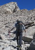
Same start as yesterday from the fee-free McKellips TH, on up Siphon Draw Trail until the top edge of the slick-rock section at:
N33.44119 W111.45928 and ~3125' altitude
This is the the start point for this hike. From here we cut straight left toward the north, descending lightly as we curved around toward the right until a short hop up about 5' after which we took a sharp left and beginning our trek up the ravine. We followed the ravine up to the NE, this time climbing 350' higher all the way to the ridge facing toward Four Peaks. From there we headed west over and past the summit of Peak 4175. Up there was where we laid eyes on the only hikers we would see in our time off-trail. There were two men on Peak 4102, which is the closest peak to the Lost Dutchman State Park, so I took a few photos of them. (We would meet near the end of our hike)

Just prior to reaching the flat summit we noticed some very fresh deer tracks and followed them to a thicket where it appeared was a regular refuge for the deer, although none were there at the time. Back toward the summit I noticed a set of tracks that appeared the deer was dragging a foot, along with some coyote prints crossing back and forth. Hmmm.

We took our time wandering around the summit then heading west toward 4102 just far enough to realize the route over there is very doable, but not sure of the time it would take we put that on our list for a future hike and headed back. The trip down took a full hour less than the climb due more to little need for route-finding than fewer breaks or stops for photos. On the descent we heard voices up behind us and realized it was the two men who had been on Peak 4102. We surmised they had climbed up earlier in the day than us and were returning the same way. But once back on the Siphon Draw Trail we dawdled so much (due to our speedy descent we weren't pressed for time) the two men caught up to us. They asked us what route we took up, to which we responded, the same way they came down. Then we asked them how they went up, realizing at that moment, we had seen them leave the Siphon Draw Trail on our way up. They turned off the trail very early and followed the steep ravine up front all the way to the top, ultimately returning the same way we did. It was the first ascent for one of them and the 16th since December 2009 for the other, over one ascent per month! From some very pertinent information they provided, we will be trying that climb soon. BTW, YES, we told them about HAZ!

All in all, a great hike that we are sure to do on a regular basis as there is so much more wandering yet to do. One last note... yesterday I wore my old worn-smooth Teva Terra-Fi's that worked super on the many smooth rock areas I climbed, but knowing we'd be going into more softer terrain, today I wore my second-newest pair. With slightly less surface area contacting on the smooth rock sections I noticed a little less grip, but they gripped better on the more coarse rock and scree.
_____________________
CannondaleKid
  1 archive
average hiking speed 1.76 mph

WARNING! Hiking and outdoor related sports can be dangerous. Be responsible and prepare for the trip. Study the area you are entering and plan accordingly. Dress for the current and unexpected weather changes. Take plenty of water. Never go alone. Make an itinerary with your plan(s), route(s), destination(s) and expected return time. Give your itinerary to trusted family and/or friends.

helpcommentissue

end of page marker